Cedar Vista Topo Map Missouri
To zoom in, hover over the map of Cedar Vista
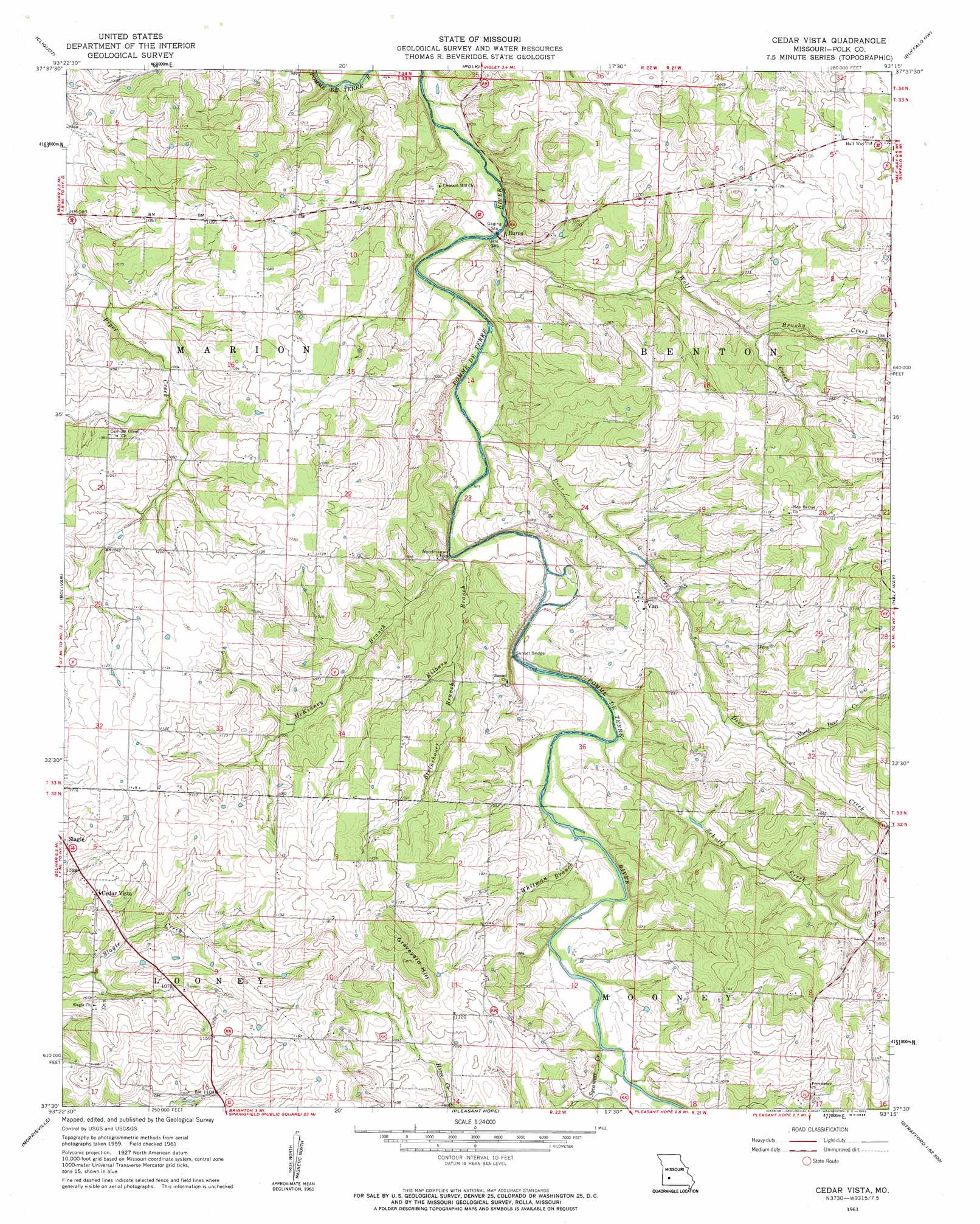
USGS Topo Quad 37093e3 - 1:24,000 scale
| Topo Map Name: | Cedar Vista |
| USGS Topo Quad ID: | 37093e3 |
| Print Size: | ca. 21 1/4" wide x 27" high |
| Southeast Coordinates: | 37.5° N latitude / 93.25° W longitude |
| Map Center Coordinates: | 37.5625° N latitude / 93.3125° W longitude |
| U.S. State: | MO |
| Filename: | o37093e3.jpg |
| Download Map JPG Image: | Cedar Vista topo map 1:24,000 scale |
| Map Type: | Topographic |
| Topo Series: | 7.5´ |
| Map Scale: | 1:24,000 |
| Source of Map Images: | United States Geological Survey (USGS) |
| Alternate Map Versions: |
Cedar Vista MO 1961, updated 1962 Download PDF Buy paper map Cedar Vista MO 2011 Download PDF Buy paper map Cedar Vista MO 2015 Download PDF Buy paper map |
1:24,000 Topo Quads surrounding Cedar Vista
Humansville |
Elkton |
Sentinel |
Urbana |
Tunas |
Fair Play |
Cliquot |
Polk |
Buffalo Nw |
Buffalo |
Aldrich |
Bolivar |
Cedar Vista |
Half Way |
Charity |
Walnut Grove |
Morrisville |
Pleasant Hope |
Fair Grove |
Elkland |
Ash Grove |
Willard |
Ebenezer |
Bassville |
Strafford |
> Back to 37093e1 at 1:100,000 scale
> Back to 37092a1 at 1:250,000 scale
> Back to U.S. Topo Maps home
Cedar Vista topo map: Gazetteer
Cedar Vista: Bridges
Sunset Bridge elevation 289m 948′Cedar Vista: Dams
Hawk Lake Dam elevation 315m 1033′Owens Lake Section 8 Dam elevation 324m 1062′
Ralph Brooks Dam elevation 341m 1118′
Cedar Vista: Populated Places
Burns elevation 287m 941′Cedar Vista elevation 335m 1099′
Sunset elevation 319m 1046′
Van elevation 320m 1049′
Cedar Vista: Reservoirs
Ralph Brooks Reservoir elevation 341m 1118′Cedar Vista: Streams
Brushy Creek elevation 308m 1010′Deer Creek elevation 284m 931′
Kilburn Branch elevation 285m 935′
McKinney Branch elevation 285m 935′
North Deer Creek elevation 315m 1033′
Schultz Creek elevation 291m 954′
Steinshouer Branch elevation 298m 977′
Sycamore Creek elevation 301m 987′
Whitman Branch elevation 293m 961′
Wolf Creek elevation 280m 918′
Cedar Vista: Summits
Graveyard Hill elevation 379m 1243′Cedar Vista digital topo map on disk
Buy this Cedar Vista topo map showing relief, roads, GPS coordinates and other geographical features, as a high-resolution digital map file on DVD: