Wichita East Topo Map Kansas
To zoom in, hover over the map of Wichita East
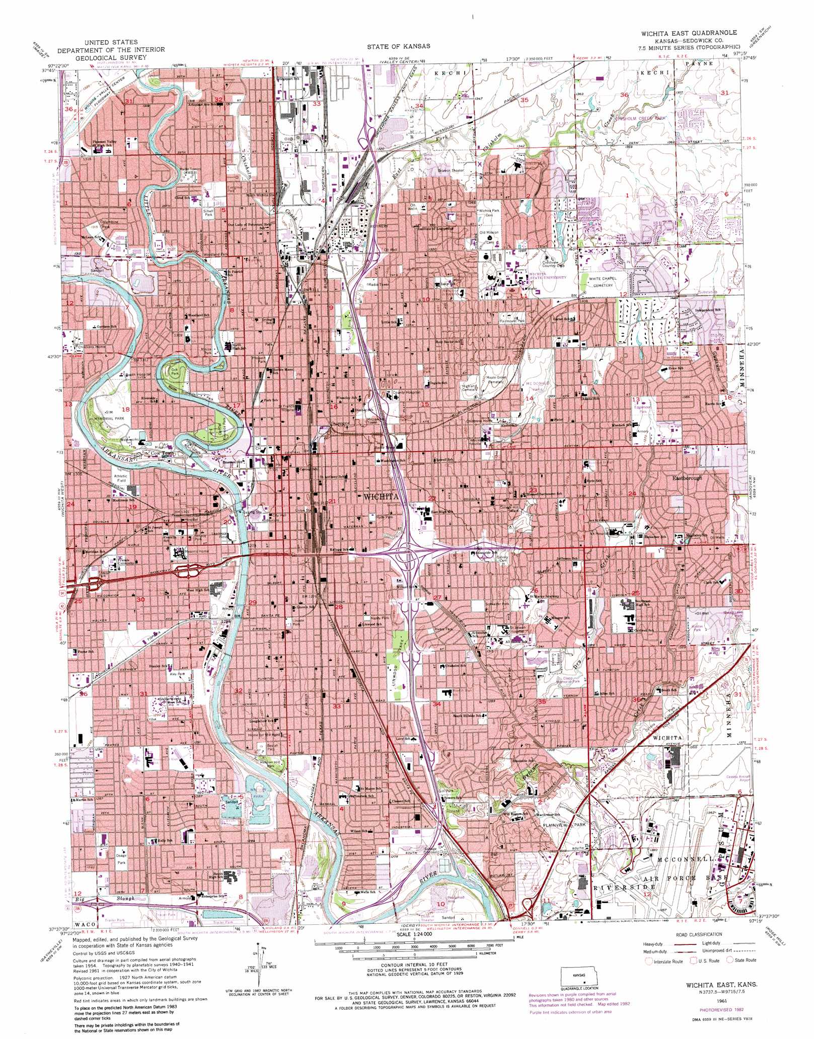
USGS Topo Quad 37097f3 - 1:24,000 scale
| Topo Map Name: | Wichita East |
| USGS Topo Quad ID: | 37097f3 |
| Print Size: | ca. 21 1/4" wide x 27" high |
| Southeast Coordinates: | 37.625° N latitude / 97.25° W longitude |
| Map Center Coordinates: | 37.6875° N latitude / 97.3125° W longitude |
| U.S. State: | KS |
| Filename: | o37097f3.jpg |
| Download Map JPG Image: | Wichita East topo map 1:24,000 scale |
| Map Type: | Topographic |
| Topo Series: | 7.5´ |
| Map Scale: | 1:24,000 |
| Source of Map Images: | United States Geological Survey (USGS) |
| Alternate Map Versions: |
Wichita East KS 1956, updated 1957 Download PDF Buy paper map Wichita East KS 1961, updated 1961 Download PDF Buy paper map Wichita East KS 1961, updated 1971 Download PDF Buy paper map Wichita East KS 1961, updated 1976 Download PDF Buy paper map Wichita East KS 1961, updated 1983 Download PDF Buy paper map Wichita East KS 2010 Download PDF Buy paper map Wichita East KS 2012 Download PDF Buy paper map Wichita East KS 2015 Download PDF Buy paper map |
1:24,000 Topo Quads surrounding Wichita East
Bentley |
Sedgwick |
Sedgwick Ne |
Whitewater |
Potwin |
Colwich |
Maize |
Valley Center |
Greenwich |
Benton |
Goddard |
Wichita West |
Wichita East |
Andover |
Santa Fe Lake |
Clearwater |
Bayneville |
Derby |
Rose Hill |
Douglass |
Millerton |
Zyba |
Belle Plaine |
Mulvane |
Udall |
> Back to 37097e1 at 1:100,000 scale
> Back to 37096a1 at 1:250,000 scale
> Back to U.S. Topo Maps home
Wichita East topo map: Gazetteer
Wichita East: Airports
Police Prison Farm Airport elevation 393m 1289′Wesley Medical Center Airport elevation 409m 1341′
Wichita East: Bridges
Murray Bridge elevation 390m 1279′Wichita East: Parks
Aley Park elevation 393m 1289′Beulah Park elevation 393m 1289′
Boston Park elevation 406m 1332′
Botanica - The Wichita Garden elevation 398m 1305′
Central Riverside Park elevation 397m 1302′
Cessna Park elevation 403m 1322′
Chisholm Creek Park elevation 413m 1354′
Clapp Memorial Park elevation 399m 1309′
College Hill Park elevation 406m 1332′
Columbine Park elevation 401m 1315′
Edgemoor Park elevation 421m 1381′
Evergreen Park elevation 401m 1315′
Fairmount Park elevation 417m 1368′
Friends Park elevation 396m 1299′
Friend's University Witchita Campus Adair - Austin Stadium elevation 396m 1299′
Gill Park elevation 390m 1279′
Grove Park elevation 403m 1322′
Henry Park elevation 394m 1292′
Hermin Hill Park elevation 393m 1289′
Hyde Park elevation 395m 1295′
Joyland Park elevation 392m 1286′
Lawrence Field elevation 394m 1292′
Lincoln Park elevation 394m 1292′
Linwood Park elevation 392m 1286′
McAdams Park elevation 398m 1305′
McDonald Park elevation 420m 1377′
Minisa Park elevation 397m 1302′
Murdock Park elevation 396m 1299′
North Riverside Park elevation 397m 1302′
Oak Park elevation 397m 1302′
Osage Park elevation 391m 1282′
Piatt Park elevation 400m 1312′
Plainview Park elevation 404m 1325′
Prospect Park elevation 398m 1305′
Rivera Park elevation 393m 1289′
Schell Park elevation 401m 1315′
Schweiter Park elevation 394m 1292′
Seneca Park elevation 396m 1299′
Sim Memorial Park elevation 399m 1309′
South Riverside Park elevation 396m 1299′
Spring Lake Park elevation 404m 1325′
Spruce Park elevation 398m 1305′
Watson Park elevation 390m 1279′
Westmoreland Park elevation 408m 1338′
Wichita State University - Cessna Annex elevation 418m 1371′
Wichita State University - Cessna Stadium elevation 419m 1374′
Wichita State University - Charles Knoch Arena elevation 417m 1368′
Wichita State University - Eck Stadium elevation 427m 1400′
Wichita State University - Sheldon Coleman Tennis Complex elevation 424m 1391′
Wichita State University - Wilkins Stadium elevation 427m 1400′
Woodland Park elevation 397m 1302′
Wichita East: Populated Places
Browns Mobile Home Park elevation 395m 1295′Colonial Mobile Home Park elevation 406m 1332′
Cow Town elevation 396m 1299′
Eastborough elevation 418m 1371′
K - 15 Mobile Home Park elevation 402m 1318′
K and R Mobile Home Park elevation 392m 1286′
Lakeshore Mobile Home Park elevation 390m 1279′
Little River Mobile Home Park elevation 397m 1302′
Midtown Mobile Home Park elevation 396m 1299′
Oaks Mobile Home Park elevation 391m 1282′
Park Place Mobile Home Park elevation 401m 1315′
Pleasant Valley Mobile Home Park elevation 401m 1315′
Reed - A - Way Mobile Home Park elevation 391m 1282′
S and L Mobile Home Park elevation 402m 1318′
Silver Spur III Mobile Home Park elevation 393m 1289′
Wichita elevation 396m 1299′
Wichita East: Streams
Chisholm Creek elevation 386m 1266′East Fork Chisholm Creek elevation 395m 1295′
Gypsum Creek elevation 392m 1286′
Little Arkansas River elevation 391m 1282′
Wichita East digital topo map on disk
Buy this Wichita East topo map showing relief, roads, GPS coordinates and other geographical features, as a high-resolution digital map file on DVD: