Twin Mountains Topo Map Colorado
To zoom in, hover over the map of Twin Mountains
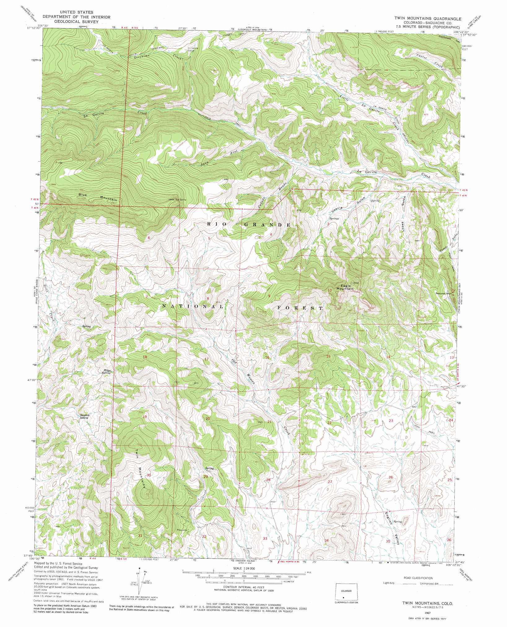
USGS Topo Quad 37106g4 - 1:24,000 scale
| Topo Map Name: | Twin Mountains |
| USGS Topo Quad ID: | 37106g4 |
| Print Size: | ca. 21 1/4" wide x 27" high |
| Southeast Coordinates: | 37.75° N latitude / 106.375° W longitude |
| Map Center Coordinates: | 37.8125° N latitude / 106.4375° W longitude |
| U.S. State: | CO |
| Filename: | o37106g4.jpg |
| Download Map JPG Image: | Twin Mountains topo map 1:24,000 scale |
| Map Type: | Topographic |
| Topo Series: | 7.5´ |
| Map Scale: | 1:24,000 |
| Source of Map Images: | United States Geological Survey (USGS) |
| Alternate Map Versions: |
Twin Mountains CO 1967, updated 1969 Download PDF Buy paper map Twin Mountains CO 1967, updated 1969 Download PDF Buy paper map Twin Mountains CO 1967, updated 1980 Download PDF Buy paper map Twin Mountains CO 2001, updated 2005 Download PDF Buy paper map Twin Mountains CO 2011 Download PDF Buy paper map Twin Mountains CO 2013 Download PDF Buy paper map Twin Mountains CO 2016 Download PDF Buy paper map |
| FStopo: | US Forest Service topo Twin Mountains is available: Download FStopo PDF Download FStopo TIF |
1:24,000 Topo Quads surrounding Twin Mountains
Saguache Park |
Grouse Creek |
Lake Mountain |
Laughlin Gulch |
Saguache |
Mesa Mountain |
Bowers Peak |
Lookout Mountain |
Lime Creek |
Swede Corners |
Pool Table Mountain |
Pine Cone Knob |
Twin Mountains |
Twin Mountains Se |
La Garita |
South Fork West |
South Fork East |
Indian Head |
Del Norte |
Sevenmile Plaza |
Beaver Creek Reservoir |
Del Norte Peak |
Horseshoe Mountain |
Dog Mountain |
Monte Vista |
> Back to 37106e1 at 1:100,000 scale
> Back to 37106a1 at 1:250,000 scale
> Back to U.S. Topo Maps home
Twin Mountains topo map: Gazetteer
Twin Mountains: Arches
La Ventana elevation 2725m 8940′Twin Mountains: Mines
Penny Bright Mine elevation 2731m 8959′Twin Mountains: Springs
Ridge Spring elevation 2846m 9337′Sunday Spring elevation 2729m 8953′
Twin Mountains: Streams
Agua Azul elevation 2697m 8848′Cañada Hondo elevation 2658m 8720′
Geronimo Creek elevation 2752m 9028′
Twin Mountains: Summits
Blue Mountain elevation 3452m 11325′Eagle Mountain elevation 3180m 10433′
Twin Mountains elevation 3210m 10531′
Twin Mountains: Valleys
Lopez Gulch elevation 2592m 8503′Usevia Gulch elevation 2607m 8553′
Twin Mountains digital topo map on disk
Buy this Twin Mountains topo map showing relief, roads, GPS coordinates and other geographical features, as a high-resolution digital map file on DVD: