Ironton Topo Map Colorado
To zoom in, hover over the map of Ironton
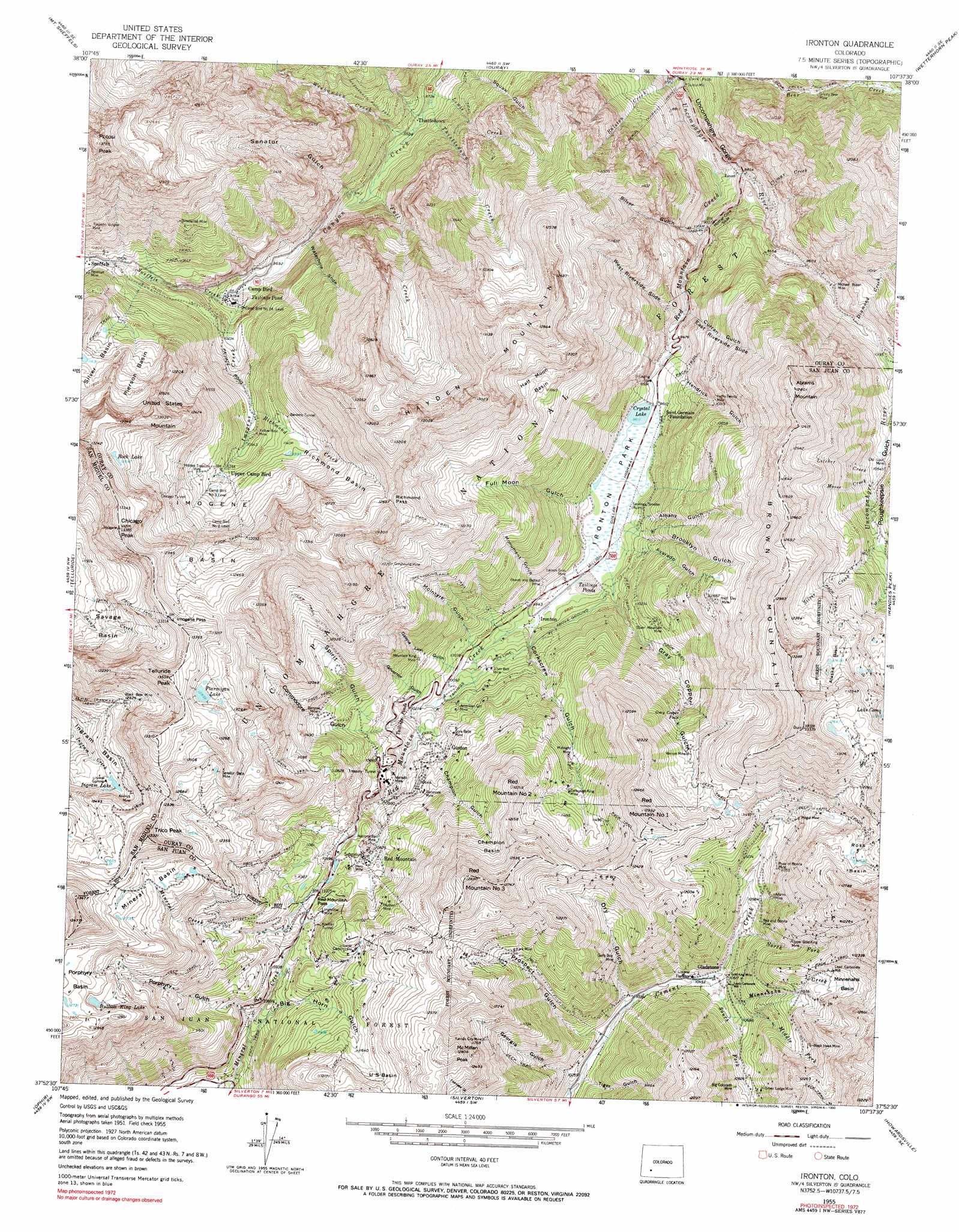
USGS Topo Quad 37107h6 - 1:24,000 scale
| Topo Map Name: | Ironton |
| USGS Topo Quad ID: | 37107h6 |
| Print Size: | ca. 21 1/4" wide x 27" high |
| Southeast Coordinates: | 37.875° N latitude / 107.625° W longitude |
| Map Center Coordinates: | 37.9375° N latitude / 107.6875° W longitude |
| U.S. State: | CO |
| Filename: | o37107h6.jpg |
| Download Map JPG Image: | Ironton topo map 1:24,000 scale |
| Map Type: | Topographic |
| Topo Series: | 7.5´ |
| Map Scale: | 1:24,000 |
| Source of Map Images: | United States Geological Survey (USGS) |
| Alternate Map Versions: |
Ironton CO 1955, updated 1957 Download PDF Buy paper map Ironton CO 1955, updated 1960 Download PDF Buy paper map Ironton CO 1955, updated 1960 Download PDF Buy paper map Ironton CO 1955, updated 1971 Download PDF Buy paper map Ironton CO 1955, updated 1990 Download PDF Buy paper map Ironton CO 2011 Download PDF Buy paper map Ironton CO 2013 Download PDF Buy paper map Ironton CO 2016 Download PDF Buy paper map |
| FStopo: | US Forest Service topo Ironton is available: Download FStopo PDF Download FStopo TIF |
1:24,000 Topo Quads surrounding Ironton
Horsefly Peak |
Ridgway |
Dallas |
Courthouse Mountain |
Sheep Mountain |
Sams |
Mount Sneffels |
Ouray |
Wetterhorn Peak |
Uncompahgre Peak |
Gray Head |
Telluride |
Ironton |
Handies Peak |
Redcloud Peak |
Mount Wilson |
Ophir |
Silverton |
Howardsville |
Pole Creek Mountain |
Hermosa Peak |
Engineer Mountain |
Snowdon Peak |
Storm King Peak |
Rio Grande Pyramid |
> Back to 37107e1 at 1:100,000 scale
> Back to 37106a1 at 1:250,000 scale
> Back to U.S. Topo Maps home
Ironton topo map: Gazetteer
Ironton: Basins
Alaska Basin elevation 3791m 12437′Champion Basin elevation 3605m 11827′
Half Moon Basin elevation 3555m 11663′
Imogene Basin elevation 3543m 11624′
Ingram Basin elevation 3580m 11745′
Mineral Basin elevation 3830m 12565′
Minnehaha Basin elevation 3640m 11942′
Pierson Basin elevation 3566m 11699′
Porphyry Basin elevation 3902m 12801′
Richmond Basin elevation 3600m 11811′
Ross Basin elevation 3739m 12267′
Silver Basin elevation 3547m 11637′
U S Basin elevation 3588m 11771′
Ironton: Cliffs
Mother Cline Slide elevation 2801m 9189′Ironton: Dams
Full Moon Dam elevation 2951m 9681′Ironton: Falls
Bear Creek Falls elevation 2587m 8487′Gray Copper Falls elevation 3302m 10833′
Ironton: Flats
Ironton Park elevation 2940m 9645′Ironton: Gaps
Imogene Pass elevation 3998m 13116′Red Mountain Pass elevation 3383m 11099′
Richmond Pass elevation 3861m 12667′
Ironton: Lakes
Bullion King Lake elevation 3830m 12565′Ingram Lake elevation 3660m 12007′
Ptarmigan Lake elevation 3946m 12946′
Rock Lake elevation 3872m 12703′
Ironton: Mines
Acapulco Mine elevation 3743m 12280′Adams Mine elevation 3413m 11197′
Ajax Mine elevation 3886m 12749′
Alabama Mine elevation 3378m 11082′
Alaska Mine elevation 3697m 12129′
Albany Mine elevation 3027m 9931′
Alma Mine elevation 3266m 10715′
Amador Mine elevation 3492m 11456′
American Girl Mine elevation 3152m 10341′
American Tunnel Mine elevation 3217m 10554′
Andrus Mine elevation 3698m 12132′
Atlantic Tunnel Mine elevation 3789m 12431′
Bailey Shaft Mine elevation 3383m 11099′
Bankers Tunnel elevation 3460m 11351′
Barhoff Mine elevation 3520m 11548′
Barstow Mine elevation 3418m 11213′
Barstow Number Two Mine elevation 3377m 11079′
Beaver and Belfast Mine elevation 3041m 9977′
Belle of the West Mine elevation 3358m 11017′
Big Colorado Mine elevation 3385m 11105′
Bi-metallist Mine elevation 3503m 11492′
Bimettalist Mine elevation 3503m 11492′
Black Bear Mine elevation 3824m 12545′
Black Bear Mine elevation 3769m 12365′
Black Hawk Mine elevation 3534m 11594′
Blackhawk Mine elevation 3534m 11594′
Brown Mountain Mine elevation 3666m 12027′
Buck Run Mine elevation 3743m 12280′
Burns Group Mine elevation 3474m 11397′
Camp Bird Number 14 Level elevation 2996m 9829′
Camp Bird Number 2 Level elevation 3560m 11679′
Camp Bird Number 3 Level elevation 3463m 11361′
Carbon Lake Mine elevation 3540m 11614′
Carbonate King Mine elevation 3418m 11213′
Charter Oak Mine elevation 3401m 11158′
Chicago Tunnel elevation 3731m 12240′
Colorado Boy Mine elevation 3012m 9881′
Columbia Mine elevation 3800m 12467′
Comet Mine elevation 3786m 12421′
Congress Mine elevation 3517m 11538′
Copper King Mine elevation 3378m 11082′
Cora Belle Mine elevation 3228m 10590′
Dawn of Day Mine elevation 3244m 10643′
Delano Mine elevation 3612m 11850′
Dixie Girl Mine elevation 3786m 12421′
Donald Mine elevation 3814m 12513′
Double Standard Mine elevation 3786m 12421′
Dunmore Mine elevation 2761m 9058′
Dutton Gibson Mine elevation 3569m 11709′
Elk Mine elevation 3233m 10606′
Enterprise Mine elevation 3409m 11184′
Estel Crosscut Mine elevation 3915m 12844′
Evaline Mine elevation 3233m 10606′
Evening Star Mine elevation 3786m 12421′
Evening Star Mine elevation 3696m 12125′
Excelsior Mine elevation 3520m 11548′
First Chance Mine elevation 3206m 10518′
Fourteen Mine elevation 3475m 11400′
Free Gold Mine elevation 3331m 10928′
Galena Queen Mine elevation 3550m 11646′
Galfy Boy Mine elevation 3323m 10902′
Galty Boy Mine elevation 3306m 10846′
Genessee Mine elevation 3282m 10767′
Gladstone Mine elevation 3323m 10902′
Gold Dollar Mine elevation 3297m 10816′
Gold King Mine elevation 3494m 11463′
Gold King Mine elevation 3241m 10633′
Grand View Mine elevation 3303m 10836′
Gray Copper Falls Mine elevation 3383m 11099′
Great Western Mine elevation 3600m 11811′
Greyhound Mine elevation 3576m 11732′
Grizzly Bear Mine elevation 3040m 9973′
Guadaloupe Mine elevation 3413m 11197′
Guston Number Five Mine elevation 3306m 10846′
Hawkeye Mine elevation 3357m 11013′
Henrietta Mine elevation 3353m 11000′
Hero Mine elevation 3344m 10971′
Hesperian Mine elevation 3788m 12427′
Hidden Treasure Mine elevation 3490m 11450′
High Tide Mine elevation 3786m 12421′
Homestake Mine elevation 3319m 10889′
Hoosier Mine elevation 3791m 12437′
Hudson Mine elevation 3536m 11601′
Idarado Mine elevation 3233m 10606′
Imogene Tunnel Mine elevation 3500m 11482′
Jackpot Mine elevation 2983m 9786′
Jay Eye See Mine elevation 3319m 10889′
Joe and John Mine elevation 3418m 11213′
Johnnie B Mine elevation 3786m 12421′
Joker Tunnel Mine elevation 3087m 10127′
Kansas City Mine elevation 3587m 11768′
Keno Mine elevation 3386m 11108′
Kentucky Giant Mine elevation 3399m 11151′
Kerr-Ouray Number Two Mine elevation 3221m 10567′
Kibbe Shaft Mine elevation 3919m 12857′
Knox Shaft Mine elevation 3302m 10833′
Koehler Tunnel elevation 3420m 11220′
Lark Mine elevation 3451m 11322′
Larson Brothers Mine elevation 2967m 9734′
Ledge Mine elevation 3254m 10675′
Lehigh Mine elevation 3786m 12421′
Little Balm of Gilead Mine elevation 2754m 9035′
Longfellow Mine elevation 3402m 11161′
Lost Day Mine elevation 3569m 11709′
Lower White Bear Mine elevation 4023m 13198′
Lucky Twenty Mine elevation 3161m 10370′
Magnet Mine elevation 3324m 10905′
Magnolia Shaft Mine elevation 3282m 10767′
Maud S Mine elevation 3066m 10059′
Meldrum Tunnel Mine elevation 3081m 10108′
Michael Breen Mine elevation 2985m 9793′
Midnight Mine elevation 3341m 10961′
Minnehaha Mine elevation 3648m 11968′
Minnesota Mine elevation 3187m 10456′
Mockingbird Mine elevation 3603m 11820′
Mogul Mine elevation 3492m 11456′
Monarch Mine elevation 3000m 9842′
Monas Queen Mine elevation 3360m 11023′
Mountain King Mine elevation 3212m 10538′
National Bell Mine elevation 3376m 11076′
Old Kentucky Mine elevation 3414m 11200′
Old Lout Mine elevation 3242m 10636′
Old Lout Mine elevation 3266m 10715′
Orphan Boy Mine elevation 3254m 10675′
Patsy Mine elevation 4026m 13208′
Paymaster Mine elevation 3188m 10459′
Pittsburgh Mine elevation 3328m 10918′
Plot Mine elevation 3786m 12421′
Porphyry Basin Mine elevation 3775m 12385′
Poughkeepsie Mine elevation 3403m 11164′
Pride of Bonita Mine elevation 3465m 11368′
Queen Anne Mine elevation 3658m 12001′
Rainbow Tunnel Mine elevation 3322m 10898′
Reckless Mine elevation 3786m 12421′
Red and Bonita Mine elevation 3347m 10980′
Red Creek Mine elevation 3480m 11417′
Red Mountain Mine elevation 3530m 11581′
Red Rogers Mine elevation 3826m 12552′
Reed Tunnel Mine elevation 3488m 11443′
Revenue Mine elevation 3260m 10695′
Robert E Lee Tunnel Mine elevation 3789m 12431′
Robinson Mine elevation 3239m 10626′
Rose Mine elevation 3713m 12181′
Saint Lawrence Mine elevation 3491m 11453′
Saint Paul Mine elevation 3529m 11578′
San Antonio Mine elevation 3512m 11522′
San Bernadino Mine elevation 3041m 9977′
San Pedro Mine elevation 3515m 11532′
Sarah Mine elevation 3725m 12221′
Saratoga Mine elevation 3086m 10124′
Saxon Mine elevation 3401m 11158′
Senator Beck Mine elevation 3868m 12690′
Serrano Mine elevation 3788m 12427′
Silver Bell Mine elevation 3065m 10055′
Silver Islet Mine elevation 3786m 12421′
Silver King Mine elevation 3666m 12027′
Silver Ledge Mine elevation 3409m 11184′
Silver Mountain Mine elevation 3177m 10423′
Snowdrift Mine elevation 3725m 12221′
Snowshoe Mine elevation 3503m 11492′
South Dakota Mine elevation 3387m 11112′
Star of the West Mine elevation 3577m 11735′
Sunshine Mine elevation 3530m 11581′
Topeka Number One Mine elevation 3163m 10377′
Topeka Number Two Mine elevation 3151m 10337′
Treasure Trove Claims elevation 3562m 11686′
Treasury Tunnel elevation 3264m 10708′
Treasury Tunnel Mine elevation 3253m 10672′
Upper Chieftain Mine elevation 4013m 13166′
Upper Gold King Mine elevation 3500m 11482′
Upper White Bear Mine elevation 4013m 13166′
Vanderbilt Mine elevation 3322m 10898′
Vernon Mine elevation 3477m 11407′
Victory Mine elevation 3383m 11099′
Webster Mine elevation 3249m 10659′
Wheel of Fortune Mine elevation 3260m 10695′
White Cloud Mine elevation 3144m 10314′
Yankee Mine elevation 3211m 10534′
Yellow Jacket Mine elevation 3319m 10889′
Yellow Rose Mine elevation 3330m 10925′
Ironton: Populated Places
Camp Bird elevation 2965m 9727′Gladstone (historical) elevation 3202m 10505′
Guston (historical) elevation 3306m 10846′
Ironton elevation 2987m 9799′
Sneffels (historical) elevation 3237m 10620′
Thistledown elevation 2661m 8730′
Ironton: Reservoirs
Crystal Lake elevation 2931m 9616′Ironton: Ridges
Oak Ridge elevation 3007m 9865′Ironton: Streams
Bear Creek elevation 2539m 8330′Climax Creek elevation 2734m 8969′
Fall Creek elevation 2754m 9035′
Imogene Creek elevation 2969m 9740′
Letcher Creek elevation 3207m 10521′
Lewis Creek elevation 2628m 8622′
Middle Fork Cement Creek elevation 3231m 10600′
Mineral Creek elevation 3091m 10141′
Minnehaha Creek elevation 3209m 10528′
Moose Creek elevation 3212m 10538′
North Fork Cement Creek elevation 3268m 10721′
Ralston Creek elevation 2533m 8310′
Red Mountain Creek elevation 2592m 8503′
Richmond Creek elevation 3277m 10751′
Silver Creek elevation 3370m 11056′
Sneffels Creek elevation 2969m 9740′
South Fork Cement Creek elevation 3186m 10452′
Thistledown Creek elevation 2635m 8645′
Weehawken Creek elevation 2664m 8740′
Ironton: Summits
Abrams Mountain elevation 3905m 12811′Brown Mountain elevation 4062m 13326′
Chicago Peak elevation 4067m 13343′
Hayden Mountain elevation 4028m 13215′
McMillan Peak elevation 3903m 12805′
Potosi Peak elevation 4195m 13763′
Red Mountain Number 1 elevation 3832m 12572′
Red Mountain Number 2 elevation 3721m 12208′
Red Mountain Number 3 elevation 3925m 12877′
Telluride Peak elevation 4108m 13477′
Trico Peak elevation 4054m 13300′
United States Mountain elevation 3967m 13015′
Ironton: Trails
Greyhound Pack Trail elevation 3435m 11269′Weehawken Pack Trail elevation 2987m 9799′
Ironton: Valleys
Albany Gulch elevation 2953m 9688′Avarado Gulch elevation 2952m 9685′
Big Horn Gulch elevation 3180m 10433′
Brooklyn Gulch elevation 2966m 9730′
Champion Gulch elevation 3098m 10164′
Commodore Gulch elevation 3173m 10410′
Corkscrew Gulch elevation 2987m 9799′
Curran Gulch elevation 2846m 9337′
Dry Gulch elevation 3158m 10360′
East Riverside Slide elevation 2872m 9422′
Full Moon Gulch elevation 2952m 9685′
Galena Lion Gulch elevation 3059m 10036′
Georgia Gulch elevation 3109m 10200′
Governor Gulch elevation 3102m 10177′
Gray Copper Gulch elevation 2965m 9727′
Hendrick Gulch elevation 2913m 9557′
McIntyre Gulch elevation 3025m 9924′
Monument Gulch elevation 2990m 9809′
Porphyry Gulch elevation 3230m 10597′
Poughkeepsie Gulch elevation 3182m 10439′
Prospect Gulch elevation 3142m 10308′
Senator Gulch elevation 2746m 9009′
Silver Gulch elevation 2693m 8835′
Spirit Gulch elevation 3095m 10154′
Tiger Gulch elevation 3118m 10229′
Waterhole Slide elevation 2933m 9622′
West Riverside Slide elevation 2852m 9356′
Ironton digital topo map on disk
Buy this Ironton topo map showing relief, roads, GPS coordinates and other geographical features, as a high-resolution digital map file on DVD: