Goldfield Topo Map Nevada
To zoom in, hover over the map of Goldfield
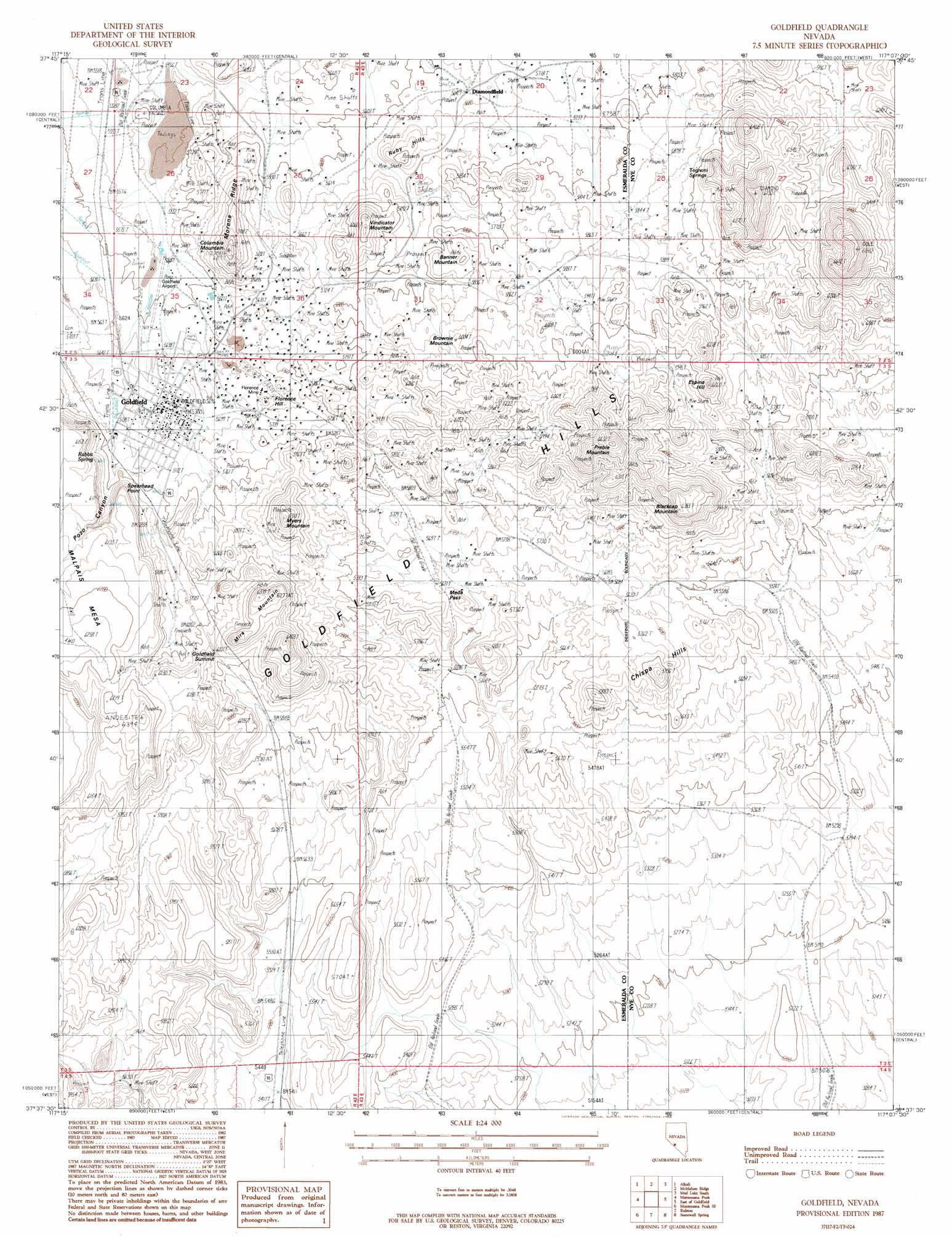
USGS Topo Quad 37117f2 - 1:24,000 scale
| Topo Map Name: | Goldfield |
| USGS Topo Quad ID: | 37117f2 |
| Print Size: | ca. 21 1/4" wide x 27" high |
| Southeast Coordinates: | 37.625° N latitude / 117.125° W longitude |
| Map Center Coordinates: | 37.6875° N latitude / 117.1875° W longitude |
| U.S. State: | NV |
| Filename: | o37117f2.jpg |
| Download Map JPG Image: | Goldfield topo map 1:24,000 scale |
| Map Type: | Topographic |
| Topo Series: | 7.5´ |
| Map Scale: | 1:24,000 |
| Source of Map Images: | United States Geological Survey (USGS) |
| Alternate Map Versions: |
Goldfield NV 1987, updated 1988 Download PDF Buy paper map Goldfield NV 2012 Download PDF Buy paper map Goldfield NV 2014 Download PDF Buy paper map |
1:24,000 Topo Quads surrounding Goldfield
Paymaster Canyon |
Klondike |
Mud Lake Nw |
Mud Lake North |
Monitor Peak |
Paymaster Ridge |
Alkali |
Mcmahon Ridge |
Mud Lake South |
Cactus Peak |
Split Mountain |
Montezuma Peak |
Goldfield |
East Of Goldfield |
White Patch Draw |
Montezuma Peak Sw |
Montezuma Peak Se |
Ralston |
Stonewall Spring |
Pack Rat Canyon |
Lida |
Mount Jackson |
Stonewall Pass |
Scottys Junction Ne |
Tolicha Peak Nw |
> Back to 37117e1 at 1:100,000 scale
> Back to 37116a1 at 1:250,000 scale
> Back to U.S. Topo Maps home
Goldfield topo map: Gazetteer
Goldfield: Airports
Goldfield Airport elevation 1709m 5606′Goldfield: Capes
Spearhead Point elevation 1845m 6053′Goldfield: Gaps
Meda Pass elevation 1740m 5708′Goldfield: Mines
Black Butte Mine elevation 1834m 6017′Combination Fraction Mine elevation 1834m 6017′
Consolidated Mine elevation 1834m 6017′
Daisy Mine Syndicate elevation 1834m 6017′
Diamondfield Mines elevation 1834m 6017′
Florence Mine elevation 1760m 5774′
Gaillac Mine elevation 1723m 5652′
Goldfield Consolidated Mines elevation 1834m 6017′
Laguna Mine elevation 1735m 5692′
Merger Mine elevation 1730m 5675′
Quartzite Mine elevation 1834m 6017′
Sandstorm Kendall Mine elevation 1834m 6017′
Silver Pick Mine elevation 1700m 5577′
Simerone Mine elevation 1834m 6017′
Vernal Mine elevation 1834m 6017′
Goldfield: Populated Places
Columbia (historical) elevation 1702m 5583′Florence Hill elevation 1747m 5731′
Goldfield elevation 1733m 5685′
Jumbotown (historical) elevation 1735m 5692′
Goldfield: Post Offices
Columbia Post Office elevation 1702m 5583′Diamondfield Post Office (historical) elevation 1721m 5646′
Goldfield Post Office elevation 1733m 5685′
Goldfield: Ridges
Mira Mountain elevation 1941m 6368′Morena Ridge elevation 1746m 5728′
Goldfield: Springs
Rabbit Spring elevation 1780m 5839′Tognoni Springs elevation 1824m 5984′
Goldfield: Summits
Banner Mountain elevation 1801m 5908′Blackcap Mountain elevation 1926m 6318′
Brownie Mountain elevation 1845m 6053′
Chispa Hills elevation 1773m 5816′
Cole Mountain elevation 2088m 6850′
Columbia Mountain elevation 1842m 6043′
Espina Hill elevation 1855m 6085′
Goldfield Summit elevation 1841m 6040′
Myers Mountain elevation 1883m 6177′
Preble Mountain elevation 1993m 6538′
Ruby Hills elevation 1743m 5718′
Vindicator Mountain elevation 1832m 6010′
Goldfield: Valleys
Pozo Canyon elevation 1736m 5695′Goldfield: Wells
McLaughlins Well elevation 1798m 5898′Goldfield digital topo map on disk
Buy this Goldfield topo map showing relief, roads, GPS coordinates and other geographical features, as a high-resolution digital map file on DVD: