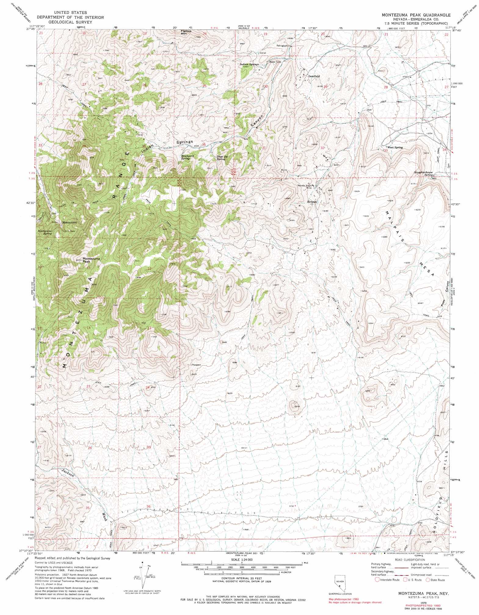
Montezuma Peak Topo Map Nevada
To zoom in, hover over the map of Montezuma Peak
USGS Topo Quad 37117f3 - 1:24,000 scale
| Topo Map Name: | Montezuma Peak |
| USGS Topo Quad ID: | 37117f3 |
| Print Size: | ca. 21 1/4" wide x 27" high |
| Southeast Coordinates: | 37.625° N latitude / 117.25° W longitude |
| Map Center Coordinates: | 37.6875° N latitude / 117.3125° W longitude |
| U.S. State: | NV |
| Filename: | o37117f3.jpg |
| Download Map JPG Image: | Montezuma Peak topo map 1:24,000 scale |
| Map Type: | Topographic |
| Topo Series: | 7.5´ |
| Map Scale: | 1:24,000 |
| Source of Map Images: | United States Geological Survey (USGS) |
| Alternate Map Versions: |
Montezuma Peak NV 1970, updated 1973 Download PDF Buy paper map Montezuma Peak NV 1970, updated 1983 Download PDF Buy paper map Montezuma Peak NV 2011 Download PDF Buy paper map Montezuma Peak NV 2014 Download PDF Buy paper map |
1:24,000 Topo Quads surrounding Montezuma Peak
Weepah |
Paymaster Canyon |
Klondike |
Mud Lake Nw |
Mud Lake North |
Goat Island |
Paymaster Ridge |
Alkali |
Mcmahon Ridge |
Mud Lake South |
Alcatraz Island |
Split Mountain |
Montezuma Peak |
Goldfield |
East Of Goldfield |
Lida Wash |
Montezuma Peak Sw |
Montezuma Peak Se |
Ralston |
Stonewall Spring |
Magruder Mountain |
Lida |
Mount Jackson |
Stonewall Pass |
Scottys Junction Ne |
> Back to 37117e1 at 1:100,000 scale
> Back to 37116a1 at 1:250,000 scale
> Back to U.S. Topo Maps home
Montezuma Peak topo map: Gazetteer
Montezuma Peak: Mines
Arizona Mine elevation 2108m 6916′Brewster Mine elevation 2215m 7267′
Bullion Mine elevation 2108m 6916′
Burchard Mine elevation 2215m 7267′
Caracas Mine elevation 2108m 6916′
Congress Mine elevation 1751m 5744′
Crocket Mine elevation 2215m 7267′
Hubbard Mine elevation 2215m 7267′
Light Mine elevation 2215m 7267′
Montezuma Mine elevation 2190m 7185′
Mountain Queen Mine elevation 2215m 7267′
Nevada Eagle Mine elevation 1942m 6371′
Norfolk Mine elevation 2215m 7267′
Osceola Mine elevation 2215m 7267′
Savage Mine elevation 2215m 7267′
Southern Mine elevation 2215m 7267′
Montezuma Peak: Populated Places
Gemfield elevation 1860m 6102′Montezuma elevation 2154m 7066′
West Spring elevation 1780m 5839′
Montezuma Peak: Post Offices
Montezuma Post Office (historical) elevation 2154m 7066′Montezuma Peak: Ranges
Montezuma Range elevation 1888m 6194′Montezuma Peak: Springs
Brickyard Spring elevation 2099m 6886′Dago Joe Spring elevation 2069m 6788′
Indian Springs elevation 1915m 6282′
Montezuma Spring elevation 2199m 7214′
Red Springs elevation 1903m 6243′
Slaughterhouse Spring elevation 1764m 5787′
Sulphur Spring elevation 1943m 6374′
Montezuma Peak: Summits
Carroll Peak elevation 2501m 8205′Malpais Mesa elevation 1979m 6492′
Montezuma Peak elevation 2546m 8353′
Montezuma Peak digital topo map on disk
Buy this Montezuma Peak topo map showing relief, roads, GPS coordinates and other geographical features, as a high-resolution digital map file on DVD: