Newark Topo Map California
To zoom in, hover over the map of Newark
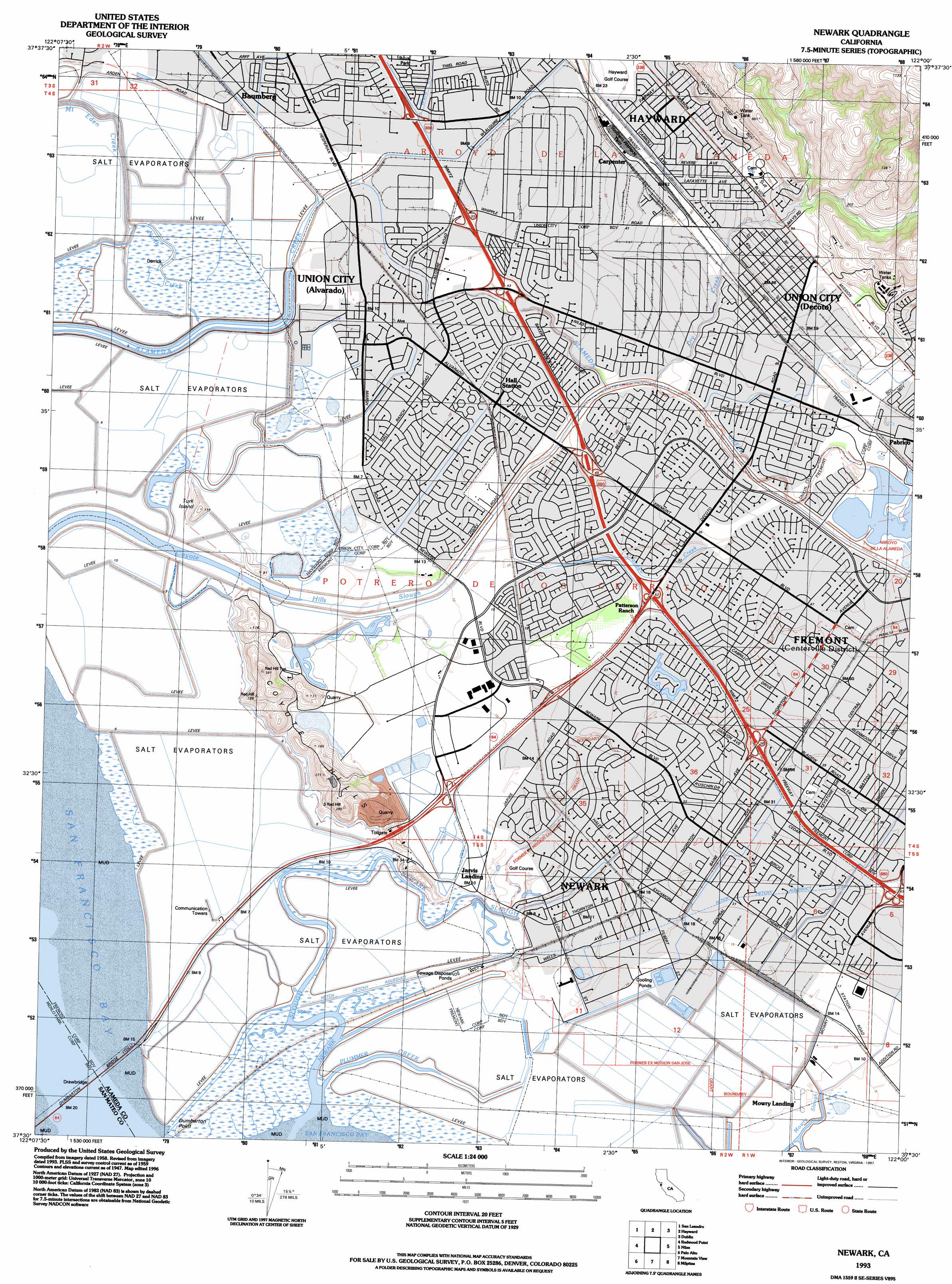
USGS Topo Quad 37122e1 - 1:24,000 scale
| Topo Map Name: | Newark |
| USGS Topo Quad ID: | 37122e1 |
| Print Size: | ca. 21 1/4" wide x 27" high |
| Southeast Coordinates: | 37.5° N latitude / 122° W longitude |
| Map Center Coordinates: | 37.5625° N latitude / 122.0625° W longitude |
| U.S. State: | CA |
| Filename: | o37122e1.jpg |
| Download Map JPG Image: | Newark topo map 1:24,000 scale |
| Map Type: | Topographic |
| Topo Series: | 7.5´ |
| Map Scale: | 1:24,000 |
| Source of Map Images: | United States Geological Survey (USGS) |
| Alternate Map Versions: |
Newark CA 1947, updated 1958 Download PDF Buy paper map Newark CA 1948 Download PDF Buy paper map Newark CA 1959, updated 1960 Download PDF Buy paper map Newark CA 1959, updated 1966 Download PDF Buy paper map Newark CA 1959, updated 1969 Download PDF Buy paper map Newark CA 1959, updated 1975 Download PDF Buy paper map Newark CA 1959, updated 1981 Download PDF Buy paper map Newark CA 1959, updated 1984 Download PDF Buy paper map Newark CA 1993, updated 1997 Download PDF Buy paper map Newark CA 1997, updated 1999 Download PDF Buy paper map Newark CA 2012 Download PDF Buy paper map Newark CA 2015 Download PDF Buy paper map |
1:24,000 Topo Quads surrounding Newark
Oakland West |
Oakland East |
Las Trampas Ridge |
Diablo |
Tassajara |
Hunters Point |
San Leandro |
Hayward |
Dublin |
Livermore |
San Mateo |
Redwood Point |
Newark |
Niles |
La Costa Valley |
Woodside |
Palo Alto |
Mountain View |
Milpitas |
Calaveras Reservoir |
La Honda |
Mindego Hill |
Cupertino |
San Jose West |
San Jose East |
> Back to 37122e1 at 1:100,000 scale
> Back to 37122a1 at 1:250,000 scale
> Back to U.S. Topo Maps home
Newark topo map: Gazetteer
Newark: Bridges
Dumbarton Bridge elevation 0m 0′Newark: Canals
Coyote Hills Slough elevation 4m 13′Newark: Capes
Dumbarton Point elevation 2m 6′Newark: Crossings
Exit 17 elevation 16m 52′Exit 19 elevation 5m 16′
Exit 21 elevation 12m 39′
Exit 22 elevation 8m 26′
Exit 23 elevation 6m 19′
Exit 24 elevation 7m 22′
Exit 36 elevation 4m 13′
Exit 37 elevation 5m 16′
Newark: Dams
Patterson 1065 Dam elevation 57m 187′Newark: Guts
Newark Slough elevation 2m 6′Newark: Parks
Alameda Creek Quarries Regional Park elevation 13m 42′Alvarado Park elevation 4m 13′
Ardenwood Regional Preserve elevation 7m 22′
Arroyo Park elevation 13m 42′
Ash Street Park elevation 6m 19′
Bidwell Park elevation 10m 32′
Birch Grove Park elevation 9m 29′
Bridgepoint Park elevation 4m 13′
Brookvale Park elevation 13m 42′
Cabrillo Park elevation 12m 39′
Casa Verde Park elevation 5m 16′
Charles F Kennedy Park elevation 16m 52′
Civic Center Park elevation 9m 29′
Contempo Park elevation 4m 13′
Coyote Hills Regional Park elevation 3m 9′
El Rancho Verde Park elevation 22m 72′
Eucalyptus Grove Park elevation 9m 29′
Fairway Greens Park elevation 15m 49′
George M Sullivan Recreation Complex elevation 6m 19′
Hall Ranch Park elevation 3m 9′
Harvey Community Park elevation 6m 19′
Lakeshore Park elevation 9m 29′
Logan Stadium elevation 13m 42′
Lowry Park elevation 6m 19′
Mayhews Landing Park elevation 6m 19′
Mirabeau Park elevation 5m 16′
Musick Park elevation 9m 29′
Newark Community Park elevation 8m 26′
North Gate Community Park elevation 9m 29′
Patterson Park elevation 11m 36′
Peixoto Playfield elevation 4m 13′
Penke Park elevation 3m 9′
San Andreas Park elevation 5m 16′
Swiss Park elevation 9m 29′
Taper Park elevation 59m 193′
Town Estates Park elevation 6m 19′
Westridge Park elevation 13m 42′
Willaim Cann Memorial Park elevation 10m 32′
Newark: Populated Places
Baumberg elevation 4m 13′Carpenter elevation 11m 36′
Hall Station elevation 5m 16′
Jarvis Landing elevation 3m 9′
Mattos elevation 12m 39′
Mowry Landing elevation 3m 9′
Newark elevation 6m 19′
Pabrico elevation 16m 52′
Union City elevation 21m 68′
Union City elevation 3m 9′
Newark: Post Offices
Alvarado Station Union City Post Office elevation 4m 13′Union City Post Office elevation 10m 32′
Newark: Ranges
Coyote Hills elevation 68m 223′Newark: Reservoirs
Jordan Pond elevation 101m 331′Newark: Streams
Crandall Creek elevation 4m 13′Dry Creek elevation 7m 22′
North Creek elevation 4m 13′
Patterson Creek elevation 3m 9′
Plummer Creek elevation 0m 0′
Ward Creek elevation 4m 13′
Newark: Summits
Red Hill elevation 87m 285′Turk Island elevation 33m 108′
Newark digital topo map on disk
Buy this Newark topo map showing relief, roads, GPS coordinates and other geographical features, as a high-resolution digital map file on DVD: