Richmond Topo Map California
To zoom in, hover over the map of Richmond
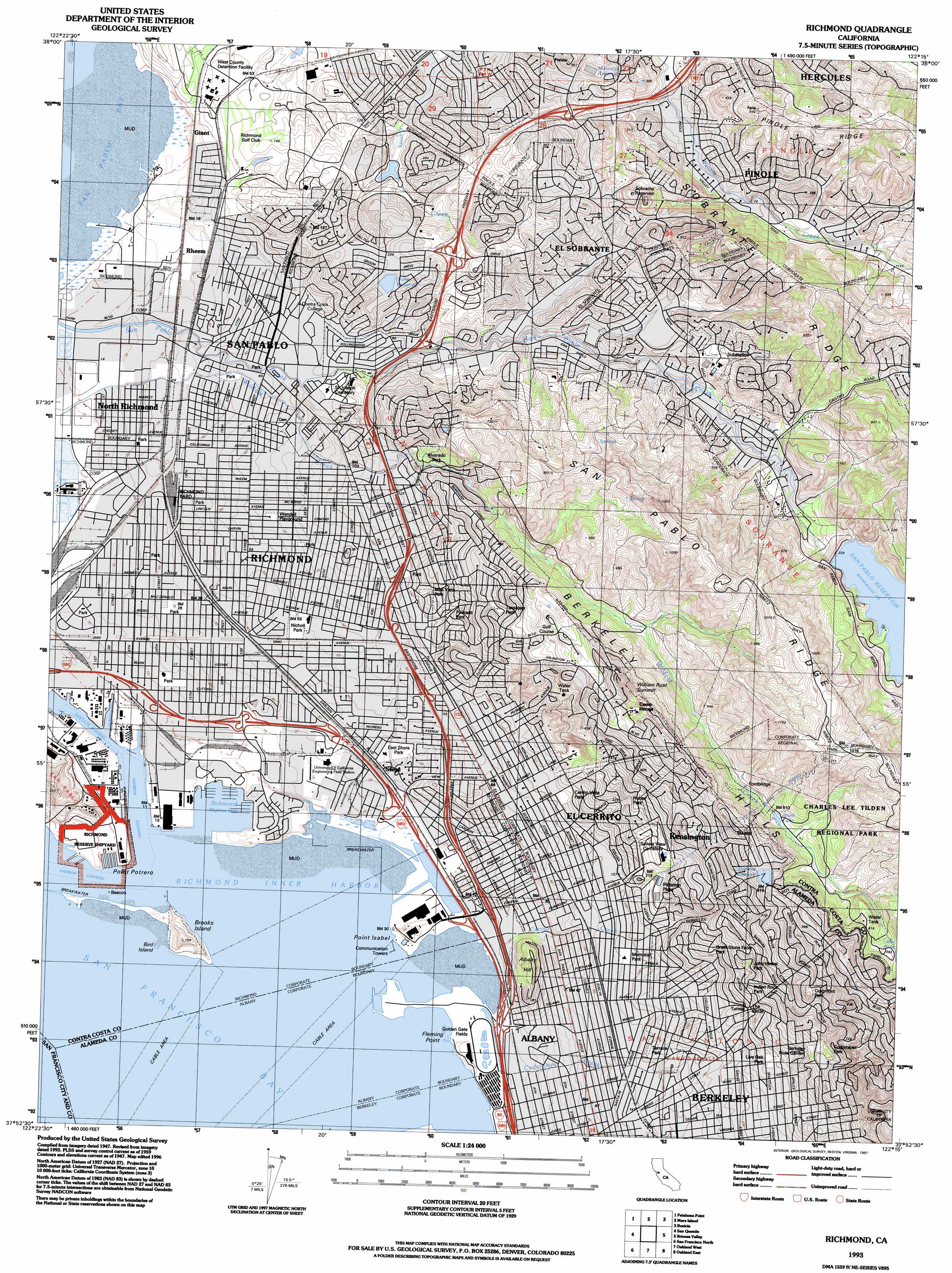
USGS Topo Quad 37122h3 - 1:24,000 scale
| Topo Map Name: | Richmond |
| USGS Topo Quad ID: | 37122h3 |
| Print Size: | ca. 21 1/4" wide x 27" high |
| Southeast Coordinates: | 37.875° N latitude / 122.25° W longitude |
| Map Center Coordinates: | 37.9375° N latitude / 122.3125° W longitude |
| U.S. State: | CA |
| Filename: | o37122h3.jpg |
| Download Map JPG Image: | Richmond topo map 1:24,000 scale |
| Map Type: | Topographic |
| Topo Series: | 7.5´ |
| Map Scale: | 1:24,000 |
| Source of Map Images: | United States Geological Survey (USGS) |
| Alternate Map Versions: |
Richmond CA 1947, updated 1952 Download PDF Buy paper map Richmond CA 1947, updated 1957 Download PDF Buy paper map Richmond CA 1949 Download PDF Buy paper map Richmond CA 1959, updated 1960 Download PDF Buy paper map Richmond CA 1959, updated 1966 Download PDF Buy paper map Richmond CA 1959, updated 1969 Download PDF Buy paper map Richmond CA 1959, updated 1974 Download PDF Buy paper map Richmond CA 1959, updated 1980 Download PDF Buy paper map Richmond CA 1993, updated 1997 Download PDF Buy paper map Richmond CA 1995, updated 1999 Download PDF Buy paper map Richmond CA 2012 Download PDF Buy paper map Richmond CA 2015 Download PDF Buy paper map |
1:24,000 Topo Quads surrounding Richmond
Petaluma River |
Sears Point |
Cuttings Wharf |
Cordelia |
Fairfield South |
Novato |
Petaluma Point |
Mare Island |
Benicia |
Vine Hill |
San Rafael |
San Quentin |
Richmond |
Briones Valley |
Walnut Creek |
Point Bonita |
San Francisco North |
Oakland West |
Oakland East |
Las Trampas Ridge |
San Francisco South |
Hunters Point |
San Leandro |
Hayward |
> Back to 37122e1 at 1:100,000 scale
> Back to 37122a1 at 1:250,000 scale
> Back to U.S. Topo Maps home
Richmond topo map: Gazetteer
Richmond: Airports
Brookside Hospital Heliport elevation 26m 85′University of California-Richmond Field Station Heliport elevation 5m 16′
Richmond: Bars
Berkely Reef elevation 0m 0′Richmond: Bays
Inner Harbor Basin elevation 0m 0′Richmond Inner Harbor elevation 0m 0′
Richmond: Bends
Potrero Turn elevation 0m 0′Richmond: Canals
Lauritzen Canal elevation 2m 6′Parr Canal elevation 1m 3′
Richmond: Capes
Fleming Point elevation 4m 13′Point Isabel elevation 3m 9′
Point Potrero elevation 0m 0′
Terrace Point elevation 40m 131′
Richmond: Channels
Ford Channel elevation 27m 88′Harbor Channel elevation 0m 0′
Santa Fe Channel elevation 0m 0′
Richmond: Crossings
Exit 10A elevation 5m 16′Exit 10B elevation 10m 32′
Exit 11 elevation 3m 9′
Exit 12 elevation 7m 22′
Exit 14A elevation 7m 22′
Exit 14B elevation 7m 22′
Exit 15 elevation 20m 65′
Exit 16A elevation 25m 82′
Exit 16B elevation 25m 82′
Exit 17 elevation 31m 101′
Exit 18 elevation 44m 144′
Exit 19A elevation 33m 108′
Exit 19B elevation 78m 255′
Exit 20 elevation 78m 255′
Exit 21 elevation 54m 177′
Exit 22 elevation 9m 29′
Exit 9A elevation 3m 9′
Exit 9B elevation 3m 9′
Richmond: Dams
Argyle Number 2 31-030 Dam elevation 124m 406′Berryman Reservoir 31-008 Dam elevation 156m 511′
C L Tilden Park 29-002 Dam elevation 236m 774′
Maloney 31-024 Dam elevation 102m 334′
North 31-027 Dam elevation 25m 82′
San Pablo 31-006 Dam elevation 93m 305′
San Pablo Clearwell 31-029 Dam elevation 73m 239′
Sobrante Clearwell 31-023 Dam elevation 77m 252′
Summit 31-012 Dam elevation 248m 813′
Richmond: Harbors
Richmond Marina Bay elevation 0m 0′Richmond Yacht Harbor elevation 0m 0′
Richmond: Islands
Bird Island elevation 0m 0′Brooks Island elevation 48m 157′
Richmond: Oilfields
San Pablo Oil Tank Farm elevation 55m 180′Richmond: Parks
Albany Cougar Athletic Field elevation 20m 65′Albany Hill Park elevation 94m 308′
Alvarado Park elevation 77m 252′
Arlington Park elevation 222m 728′
Atchison Village Park elevation 4m 13′
Barbara and Jay Vincent Park elevation 2m 6′
Berkeley Rose Garden elevation 148m 485′
Booker T Anderson Eastshore Park elevation 9m 29′
Boorman Park elevation 12m 39′
Brooks Island Regional Shoreline elevation 4m 13′
Burg Park elevation 24m 78′
Canyon Trail Park elevation 59m 193′
Casa Cerrito Park elevation 36m 118′
Casa Cerrito Recreation Center elevation 34m 111′
Castro Park elevation 37m 121′
Central Park elevation 6m 19′
Cerrito Vista Park elevation 42m 137′
Codornices Park elevation 155m 508′
Cragmont Park elevation 241m 790′
Creekside Park elevation 14m 45′
Creekside Park elevation 7m 22′
Crescent Park elevation 4m 13′
El Cerrito Community Swim Center elevation 31m 101′
Elm Park elevation 8m 26′
Fairmead Park elevation 62m 203′
Fairmont Park elevation 14m 45′
Great Stone Face Park elevation 105m 344′
Grotto Rock Park elevation 159m 521′
Harding Park elevation 24m 78′
Hillside Natural Area elevation 134m 439′
Hilltop Lake Park elevation 31m 101′
Hilltop Park elevation 81m 265′
Hilltop Park elevation 53m 173′
Huber Park elevation 111m 364′
Indian Rock Park elevation 121m 396′
J F Kennedy Park elevation 14m 45′
John Hinkel Park elevation 121m 396′
John Hubert Davis Park elevation 13m 42′
Kennedy Grove Regional Recreation Area elevation 135m 442′
La Moine Valley View Park elevation 73m 239′
Live Oak Park elevation 86m 282′
Lucas Park elevation 10m 32′
M L King Memorial Park elevation 4m 13′
Marina Park elevation 2m 6′
Memorial Park elevation 9m 29′
Michigan Park elevation 226m 741′
Middle School Park elevation 8m 26′
Mira Vista Park elevation 36m 118′
Montalvin Park elevation 24m 78′
Mortar Rock Park elevation 131m 429′
Nevin Park elevation 7m 22′
Nicholl Park elevation 16m 52′
North Richmond Ballpark elevation 6m 19′
Nustrom Park elevation 5m 16′
Opal Staniek Tot Lot elevation 18m 59′
Parchester Park elevation 8m 26′
Parchester Playfield elevation 8m 26′
Pinole Valley Park elevation 51m 167′
Plaza One Park elevation 12m 39′
Poinsett Park elevation 49m 160′
Point Isabel Regional Shoreline elevation 2m 6′
Rain Cloud Park elevation 145m 475′
Remillard Park elevation 252m 826′
Rosie the Riveter WWII Home Front National Historical Park elevation 2m 6′
San Gabriel Municipal Park elevation 19m 62′
Savage Avenue Park elevation 26m 85′
Shields-Reid Park elevation 8m 26′
Shimada Friendship Park elevation 5m 16′
Sobrante Ridge Regional Preserve elevation 203m 666′
Stewart Draw Park elevation 42m 137′
Stewart Playground elevation 6m 19′
Tassajara Park elevation 122m 400′
Terrace View Park elevation 329m 1079′
Tiller Park elevation 28m 91′
University Park elevation 11m 36′
Wendell Playground elevation 22m 72′
Wildcat Canyon Regional Park elevation 146m 479′
Wood Park elevation 13m 42′
Richmond: Populated Places
Albany elevation 13m 42′Atchison Village elevation 4m 13′
Cragmont elevation 217m 711′
Cragmont elevation 230m 754′
East Richmond elevation 87m 285′
East Richmond Heights elevation 118m 387′
Easter Hill Village elevation 14m 45′
El Cerrito elevation 21m 68′
El Sobrante elevation 57m 187′
Giant elevation 7m 22′
Kensington elevation 177m 580′
La Loma Park elevation 185m 606′
Montalvin elevation 21m 68′
Normandy Village elevation 79m 259′
North Richmond elevation 5m 16′
Nystrom Village elevation 5m 16′
Rheem elevation 8m 26′
Richmond elevation 14m 45′
Rollingwood elevation 23m 75′
San Pablo elevation 16m 52′
Stege elevation 7m 22′
Tara Hills elevation 28m 91′
Thousand Oaks elevation 73m 239′
Triangle Court elevation 9m 29′
University Village elevation 8m 26′
Westbrae elevation 24m 78′
Richmond: Post Offices
Albany Post Office elevation 17m 55′El Cerrito Post Office elevation 16m 52′
El Sobrante Post Office elevation 58m 190′
Fairmount Station El Cerrito Post Office elevation 8m 26′
Giant Post Office (historical) elevation 7m 22′
Landscape Station Berkeley Post Office elevation 67m 219′
Mira Vista Station Richmond Post Office elevation 31m 101′
North Berkeley Station Berkeley Post Office elevation 77m 252′
Richmond Post Office elevation 9m 29′
San Pablo Post Office elevation 16m 52′
Station A Berkeley Post Office elevation 15m 49′
Station A Richmond Post Office elevation 13m 42′
Richmond: Reservoirs
Berryman Reservoir elevation 156m 511′Jewel Lake elevation 155m 508′
Lake Anza elevation 242m 793′
Maloney Reservoir elevation 102m 334′
North Reservoir elevation 65m 213′
San Pablo Reservoir elevation 93m 305′
Sobrante Reservoir elevation 134m 439′
Summit Reservoir elevation 248m 813′
Richmond: Ridges
Pinole Ridge elevation 156m 511′San Pablo Ridge elevation 300m 984′
Sobrante Ridge elevation 251m 823′
Richmond: Streams
Cerrito Creek elevation 1m 3′Codornices Creek elevation 3m 9′
Richmond: Summits
Albany Hill elevation 91m 298′William Rust Summit elevation 306m 1003′
Richmond digital topo map on disk
Buy this Richmond topo map showing relief, roads, GPS coordinates and other geographical features, as a high-resolution digital map file on DVD: