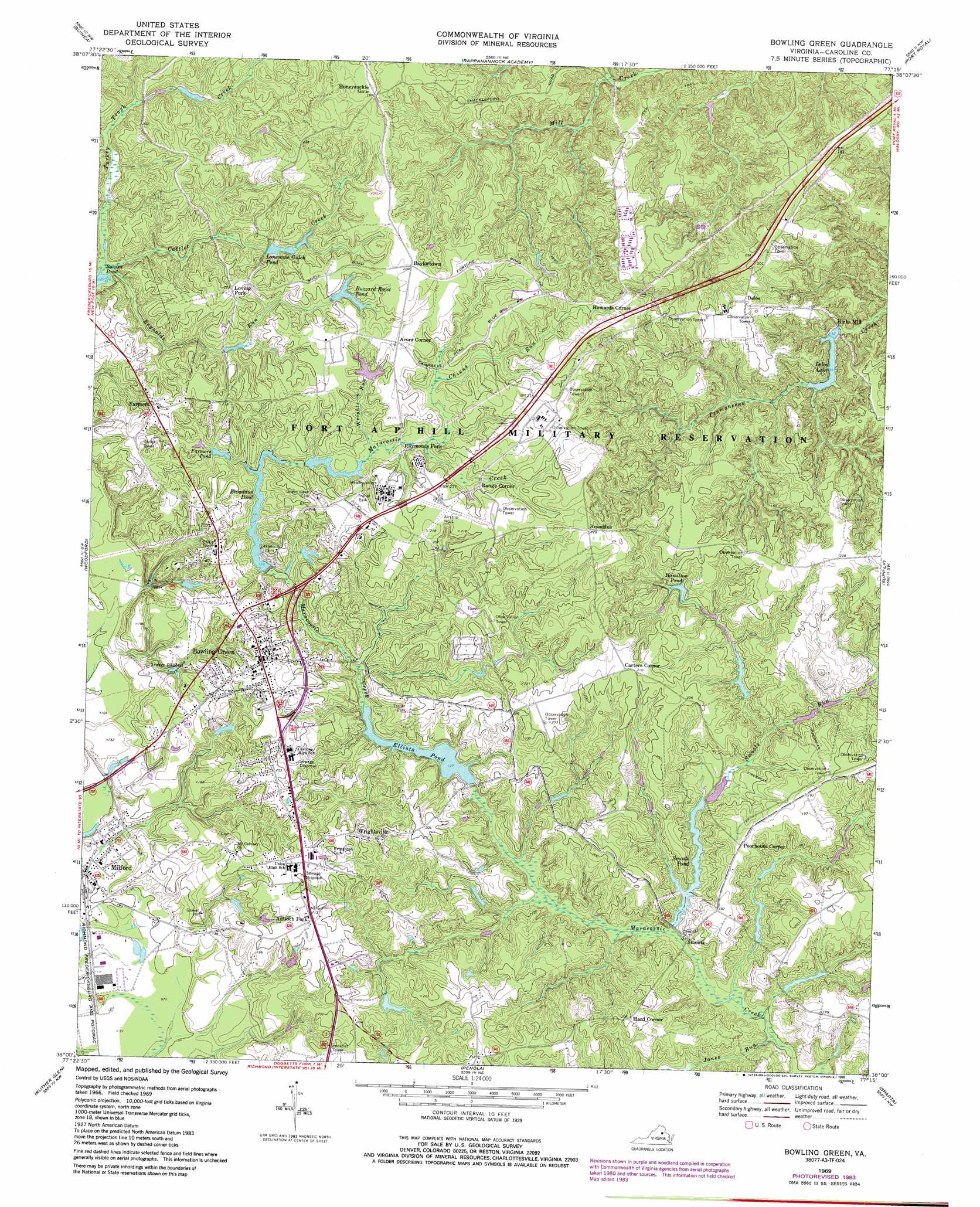
Bowling Green Topo Map Virginia
To zoom in, hover over the map of Bowling Green
USGS Topo Quad 38077a3 - 1:24,000 scale
| Topo Map Name: | Bowling Green |
| USGS Topo Quad ID: | 38077a3 |
| Print Size: | ca. 21 1/4" wide x 27" high |
| Southeast Coordinates: | 38° N latitude / 77.25° W longitude |
| Map Center Coordinates: | 38.0625° N latitude / 77.3125° W longitude |
| U.S. State: | VA |
| Filename: | o38077a3.jpg |
| Download Map JPG Image: | Bowling Green topo map 1:24,000 scale |
| Map Type: | Topographic |
| Topo Series: | 7.5´ |
| Map Scale: | 1:24,000 |
| Source of Map Images: | United States Geological Survey (USGS) |
| Alternate Map Versions: |
Bowling Green VA 1949, updated 1961 Download PDF Buy paper map Bowling Green VA 1949, updated 1965 Download PDF Buy paper map Bowling Green VA 1969, updated 1971 Download PDF Buy paper map Bowling Green VA 1969, updated 1973 Download PDF Buy paper map Bowling Green VA 1969, updated 1984 Download PDF Buy paper map Bowling Green VA 1969, updated 1989 Download PDF Buy paper map Bowling Green VA 1994, updated 1997 Download PDF Buy paper map Bowling Green VA 2010 Download PDF Buy paper map Bowling Green VA 2013 Download PDF Buy paper map Bowling Green VA 2016 Download PDF Buy paper map |
1:24,000 Topo Quads surrounding Bowling Green
Salem Church |
Fredericksburg |
Passapatanzy |
King George |
Dahlgren |
Spotsylvania |
Guinea |
Rappahannock Academy |
Port Royal |
Rollins Fork |
Ladysmith |
Woodford |
Bowling Green |
Supply |
Loretto |
Hewlett |
Ruther Glen |
Penola |
Sparta |
Cauthornville |
Hanover Academy |
Ashland |
Hanover |
Beulahville |
Aylett |
> Back to 38077a1 at 1:100,000 scale
> Back to 38076a1 at 1:250,000 scale
> Back to U.S. Topo Maps home
Bowling Green topo map: Gazetteer
Bowling Green: Dams
Beaverdam Pond Dam elevation 55m 180′Broaddus Dam elevation 49m 160′
Buzzard Roost Pond Dam elevation 60m 196′
D Pitts Dam elevation 35m 114′
Delos Dam elevation 27m 88′
Elliotts Dam elevation 40m 131′
Lonesome Gulch Dam elevation 61m 200′
Smoots Dam elevation 36m 118′
Bowling Green: Populated Places
Acors Corner elevation 64m 209′Antioch Fork elevation 64m 209′
Baylortown elevation 68m 223′
Bowling Green elevation 69m 226′
Broaddus elevation 72m 236′
Carters Corner elevation 64m 209′
Delos elevation 60m 196′
Hard Corner elevation 61m 200′
Hicks Mill elevation 37m 121′
Howards Corner elevation 67m 219′
Loving Fork elevation 68m 223′
Milford elevation 30m 98′
Poorhouse Corner elevation 59m 193′
Range Corner elevation 58m 190′
Raymonds Fork elevation 53m 173′
Smoots elevation 37m 121′
Wrightsville elevation 62m 203′
Bowling Green: Reservoirs
Beaverdam Pond elevation 55m 180′Broaddus Pond elevation 49m 160′
Buzzard Roost Pond elevation 60m 196′
Delos Lake elevation 27m 88′
Delos Pond elevation 28m 91′
Elliots Pond elevation 40m 131′
Elliotts Pond elevation 36m 118′
Farmers Pond elevation 49m 160′
Hamilton Pond elevation 45m 147′
Lonesome Gulch Lake elevation 61m 200′
Lonesome Gulch Pond elevation 48m 157′
Smoots Pond elevation 36m 118′
Bowling Green: Streams
Cattlet Creek elevation 38m 124′Chinns Run elevation 51m 167′
Jones Run elevation 29m 95′
Reynolds Run elevation 38m 124′
Smoots Run elevation 32m 104′
Turkey Track Creek elevation 38m 124′
Wrights Run elevation 50m 164′
Bowling Green digital topo map on disk
Buy this Bowling Green topo map showing relief, roads, GPS coordinates and other geographical features, as a high-resolution digital map file on DVD:
Atlantic Coast (NY, NJ, PA, DE, MD, VA, NC)
Buy digital topo maps: Atlantic Coast (NY, NJ, PA, DE, MD, VA, NC)
 map DVD")