Mine Run Topo Map Virginia
To zoom in, hover over the map of Mine Run
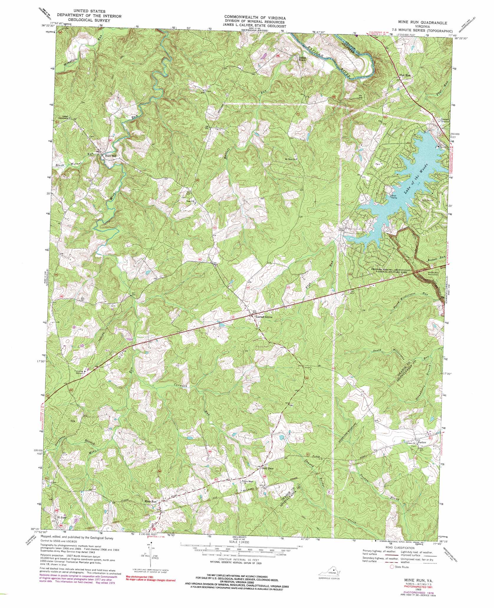
USGS Topo Quad 38077c7 - 1:24,000 scale
| Topo Map Name: | Mine Run |
| USGS Topo Quad ID: | 38077c7 |
| Print Size: | ca. 21 1/4" wide x 27" high |
| Southeast Coordinates: | 38.25° N latitude / 77.75° W longitude |
| Map Center Coordinates: | 38.3125° N latitude / 77.8125° W longitude |
| U.S. State: | VA |
| Filename: | o38077c7.jpg |
| Download Map JPG Image: | Mine Run topo map 1:24,000 scale |
| Map Type: | Topographic |
| Topo Series: | 7.5´ |
| Map Scale: | 1:24,000 |
| Source of Map Images: | United States Geological Survey (USGS) |
| Alternate Map Versions: |
Mine Run VA 1943, updated 1961 Download PDF Buy paper map Mine Run VA 1969, updated 1971 Download PDF Buy paper map Mine Run VA 1969, updated 1979 Download PDF Buy paper map Mine Run VA 1969, updated 1991 Download PDF Buy paper map Mine Run VA 2010 Download PDF Buy paper map Mine Run VA 2013 Download PDF Buy paper map Mine Run VA 2016 Download PDF Buy paper map |
1:24,000 Topo Quads surrounding Mine Run
Castleton |
Brandy Station |
Remington |
Midland |
Somerville |
Culpeper West |
Culpeper East |
Germanna Bridge |
Richardsville |
Storck |
Rapidan |
Unionville |
Mine Run |
Chancellorsville |
Salem Church |
Orange |
Lahore |
Belmont |
Brokenburg |
Spotsylvania |
Louisa |
Mineral |
Lake Anna West |
Lake Anna East |
Ladysmith |
> Back to 38077a1 at 1:100,000 scale
> Back to 38076a1 at 1:250,000 scale
> Back to U.S. Topo Maps home
Mine Run topo map: Gazetteer
Mine Run: Dams
Lake of the Woods Dam elevation 96m 314′Mine Run: Populated Places
Burr Hill elevation 84m 275′Flat Run elevation 109m 357′
Gold Dale elevation 148m 485′
Indian Town elevation 69m 226′
Mine Run elevation 143m 469′
Parker elevation 130m 426′
Mine Run: Reservoirs
Lake of the Woods elevation 96m 314′Mine Run: Streams
Black Walnut Run elevation 75m 246′Cormack Run elevation 146m 479′
Flat Run elevation 98m 321′
Russell Run elevation 60m 196′
Soapstone Branch elevation 103m 337′
Strawberry Branch elevation 93m 305′
Mine Run digital topo map on disk
Buy this Mine Run topo map showing relief, roads, GPS coordinates and other geographical features, as a high-resolution digital map file on DVD:
Atlantic Coast (NY, NJ, PA, DE, MD, VA, NC)
Buy digital topo maps: Atlantic Coast (NY, NJ, PA, DE, MD, VA, NC)
 map DVD")