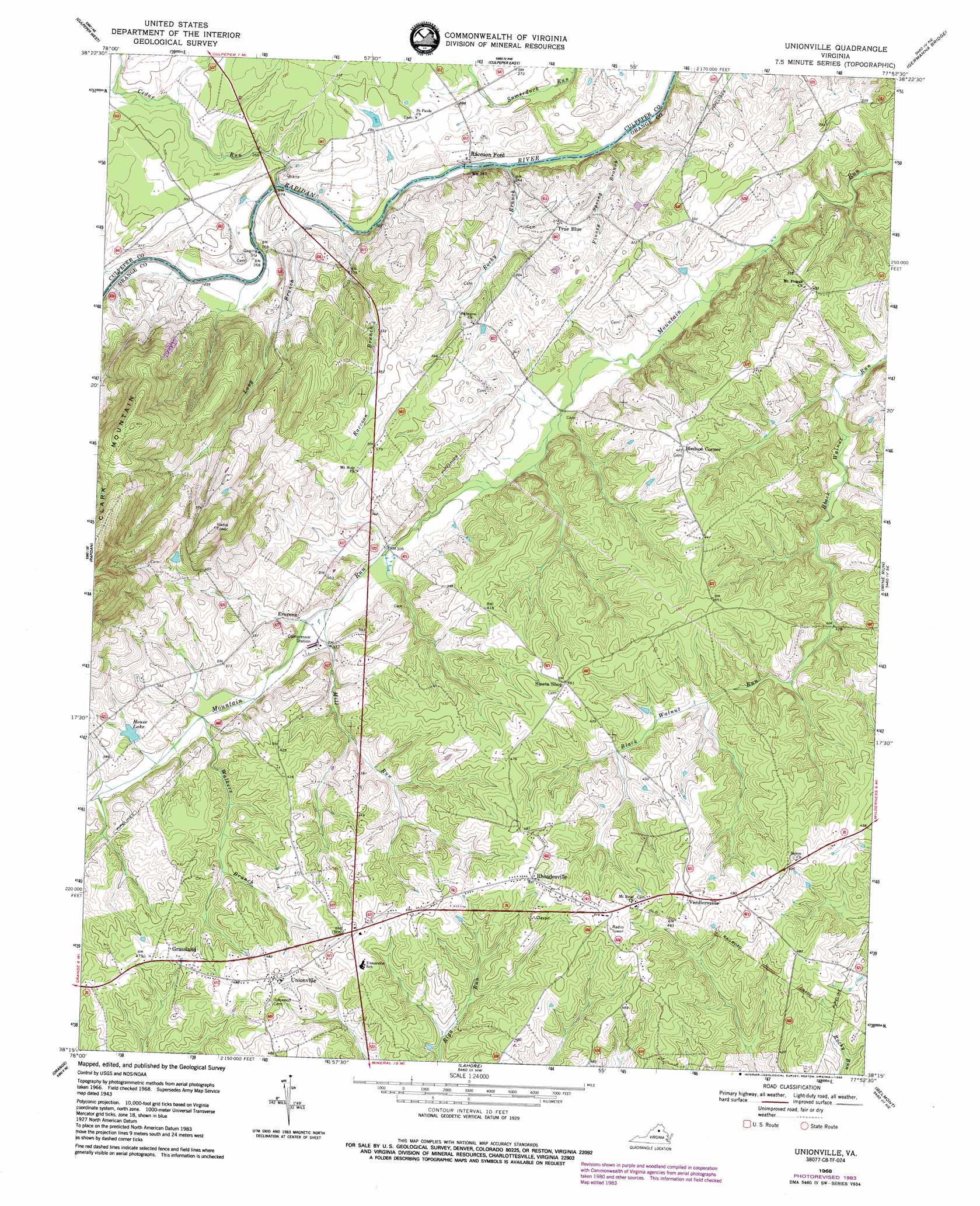
Unionville Topo Map Virginia
To zoom in, hover over the map of Unionville
USGS Topo Quad 38077c8 - 1:24,000 scale
| Topo Map Name: | Unionville |
| USGS Topo Quad ID: | 38077c8 |
| Print Size: | ca. 21 1/4" wide x 27" high |
| Southeast Coordinates: | 38.25° N latitude / 77.875° W longitude |
| Map Center Coordinates: | 38.3125° N latitude / 77.9375° W longitude |
| U.S. State: | VA |
| Filename: | o38077c8.jpg |
| Download Map JPG Image: | Unionville topo map 1:24,000 scale |
| Map Type: | Topographic |
| Topo Series: | 7.5´ |
| Map Scale: | 1:24,000 |
| Source of Map Images: | United States Geological Survey (USGS) |
| Alternate Map Versions: |
Unionville VA 1943, updated 1961 Download PDF Buy paper map Unionville VA 1968, updated 1970 Download PDF Buy paper map Unionville VA 1968, updated 1984 Download PDF Buy paper map Unionville VA 1968, updated 1988 Download PDF Buy paper map Unionville VA 2010 Download PDF Buy paper map Unionville VA 2013 Download PDF Buy paper map Unionville VA 2016 Download PDF Buy paper map |
1:24,000 Topo Quads surrounding Unionville
Woodville |
Castleton |
Brandy Station |
Remington |
Midland |
Brightwood |
Culpeper West |
Culpeper East |
Germanna Bridge |
Richardsville |
Madison Mills |
Rapidan |
Unionville |
Mine Run |
Chancellorsville |
Gordonsville |
Orange |
Lahore |
Belmont |
Brokenburg |
Boswells Tavern |
Louisa |
Mineral |
Lake Anna West |
Lake Anna East |
> Back to 38077a1 at 1:100,000 scale
> Back to 38076a1 at 1:250,000 scale
> Back to U.S. Topo Maps home
Unionville topo map: Gazetteer
Unionville: Airports
Atlantic Research Corp Heliport elevation 120m 393′Unionville: Bridges
Raccoon Bridge (historical) elevation 80m 262′Somerville Bridge (historical) elevation 71m 232′
Unionville: Populated Places
Bledsoe Corner elevation 134m 439′Everona elevation 99m 324′
Grassland elevation 146m 479′
Raccoon Ford elevation 75m 246′
Rhoadesville elevation 152m 498′
True Blue elevation 100m 328′
Unionville elevation 156m 511′
Verdiersville elevation 156m 511′
Unionville: Reservoirs
House Lake elevation 107m 351′Unionville: Streams
Cabin Branch elevation 76m 249′Cedar Run elevation 72m 236′
Finney Spring Branch elevation 75m 246′
Long Branch elevation 69m 226′
Mill Run elevation 95m 311′
Raccoon Branch elevation 71m 232′
Rocky Branch elevation 78m 255′
Walkers Branch elevation 99m 324′
Unionville digital topo map on disk
Buy this Unionville topo map showing relief, roads, GPS coordinates and other geographical features, as a high-resolution digital map file on DVD:
Atlantic Coast (NY, NJ, PA, DE, MD, VA, NC)
Buy digital topo maps: Atlantic Coast (NY, NJ, PA, DE, MD, VA, NC)
 map DVD")