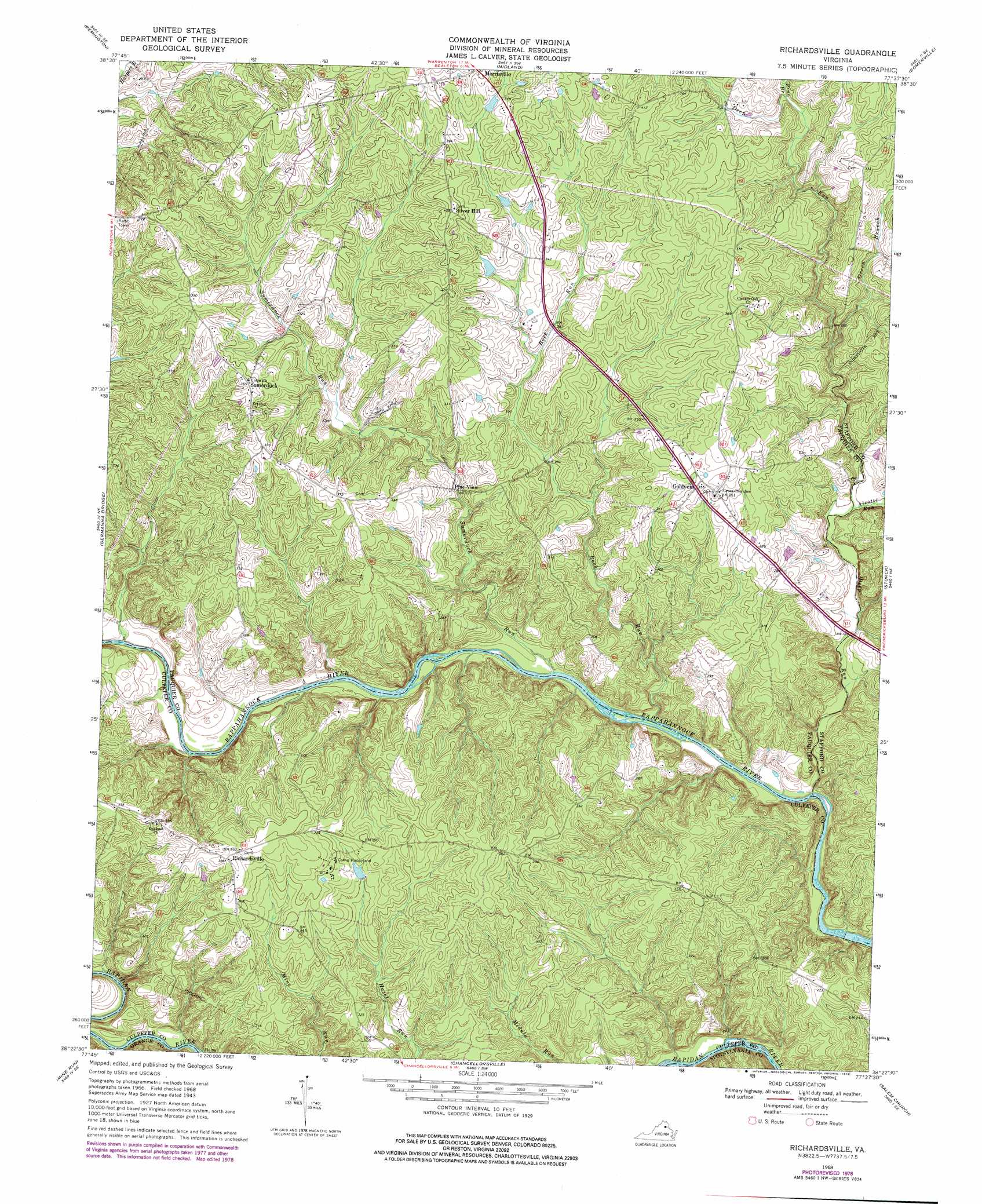
Richardsville Topo Map Virginia
To zoom in, hover over the map of Richardsville
USGS Topo Quad 38077d6 - 1:24,000 scale
| Topo Map Name: | Richardsville |
| USGS Topo Quad ID: | 38077d6 |
| Print Size: | ca. 21 1/4" wide x 27" high |
| Southeast Coordinates: | 38.375° N latitude / 77.625° W longitude |
| Map Center Coordinates: | 38.4375° N latitude / 77.6875° W longitude |
| U.S. State: | VA |
| Filename: | o38077d6.jpg |
| Download Map JPG Image: | Richardsville topo map 1:24,000 scale |
| Map Type: | Topographic |
| Topo Series: | 7.5´ |
| Map Scale: | 1:24,000 |
| Source of Map Images: | United States Geological Survey (USGS) |
| Alternate Map Versions: |
Richardsville VA 1953 Download PDF Buy paper map Richardsville VA 1968, updated 1970 Download PDF Buy paper map Richardsville VA 1968, updated 1976 Download PDF Buy paper map Richardsville VA 1968, updated 1978 Download PDF Buy paper map Richardsville VA 1998, updated 2001 Download PDF Buy paper map Richardsville VA 2010 Download PDF Buy paper map Richardsville VA 2013 Download PDF Buy paper map Richardsville VA 2016 Download PDF Buy paper map |
1:24,000 Topo Quads surrounding Richardsville
Jeffersonton |
Warrenton |
Catlett |
Nokesville |
Independent Hill |
Brandy Station |
Remington |
Midland |
Somerville |
Joplin |
Culpeper East |
Germanna Bridge |
Richardsville |
Storck |
Stafford |
Unionville |
Mine Run |
Chancellorsville |
Salem Church |
Fredericksburg |
Lahore |
Belmont |
Brokenburg |
Spotsylvania |
Guinea |
> Back to 38077a1 at 1:100,000 scale
> Back to 38076a1 at 1:250,000 scale
> Back to U.S. Topo Maps home
Richardsville topo map: Gazetteer
Richardsville: Populated Places
Deerfield Estates elevation 118m 387′Golden Hills elevation 122m 400′
Goldvein elevation 104m 341′
Pine View elevation 77m 252′
Queens Guard elevation 92m 301′
Richardsville elevation 115m 377′
Richardsville South elevation 107m 351′
Sherwood Estates elevation 93m 305′
Silver Hill elevation 126m 413′
Sumerduck elevation 108m 354′
Richardsville: Post Offices
Goldvein Post Office elevation 102m 334′Summerduck Post Office elevation 106m 347′
Richardsville: Streams
Alcotti Run elevation 54m 177′Deep Run elevation 49m 160′
Flat Run elevation 52m 170′
Green Branch elevation 65m 213′
Pine Branch elevation 87m 285′
Rock Run elevation 57m 187′
Sumerduck Run elevation 60m 196′
Richardsville digital topo map on disk
Buy this Richardsville topo map showing relief, roads, GPS coordinates and other geographical features, as a high-resolution digital map file on DVD:
Atlantic Coast (NY, NJ, PA, DE, MD, VA, NC)
Buy digital topo maps: Atlantic Coast (NY, NJ, PA, DE, MD, VA, NC)
 map DVD")