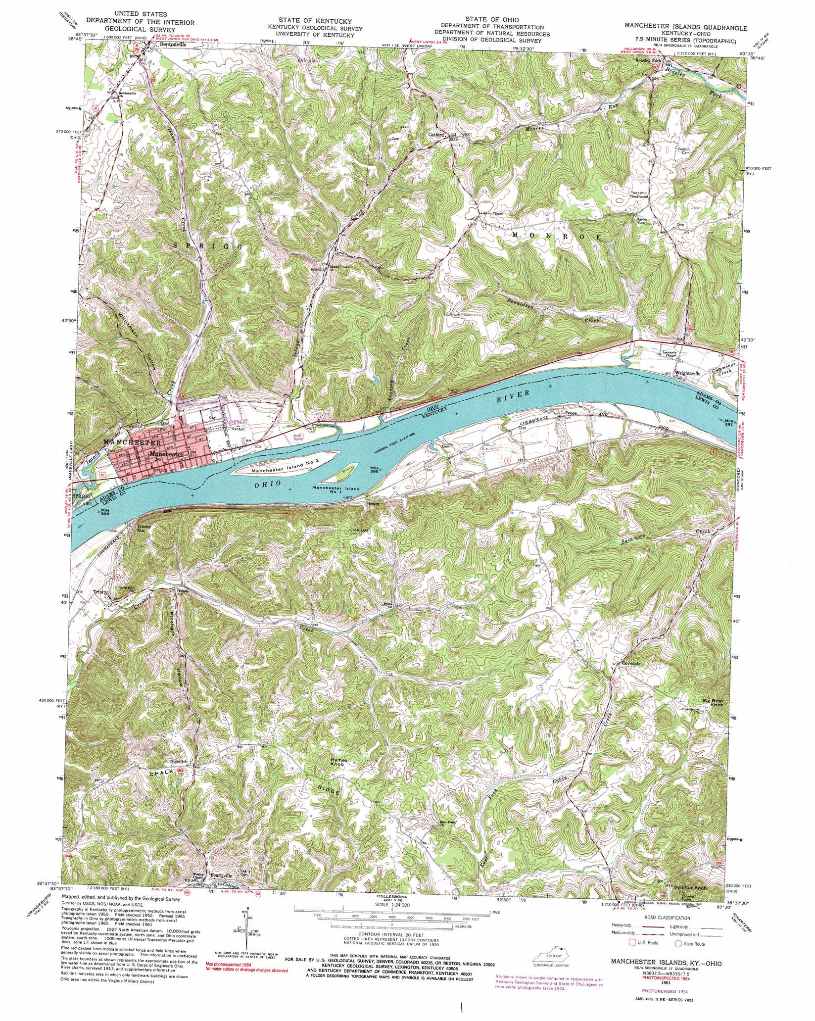
Manchester Islands Topo Map Kentucky
To zoom in, hover over the map of Manchester Islands
USGS Topo Quad 38083f5 - 1:24,000 scale
| Topo Map Name: | Manchester Islands |
| USGS Topo Quad ID: | 38083f5 |
| Print Size: | ca. 21 1/4" wide x 27" high |
| Southeast Coordinates: | 38.625° N latitude / 83.5° W longitude |
| Map Center Coordinates: | 38.6875° N latitude / 83.5625° W longitude |
| U.S. States: | KY, OH |
| Filename: | o38083f5.jpg |
| Download Map JPG Image: | Manchester Islands topo map 1:24,000 scale |
| Map Type: | Topographic |
| Topo Series: | 7.5´ |
| Map Scale: | 1:24,000 |
| Source of Map Images: | United States Geological Survey (USGS) |
| Alternate Map Versions: |
Manchester Islands KY 1952, updated 1954 Download PDF Buy paper map Manchester Islands KY 1961, updated 1963 Download PDF Buy paper map Manchester Islands KY 1961, updated 1973 Download PDF Buy paper map Manchester Islands KY 1961, updated 1975 Download PDF Buy paper map Manchester Islands KY 1961, updated 1991 Download PDF Buy paper map Manchester Islands KY 2010 Download PDF Buy paper map Manchester Islands KY 2013 Download PDF Buy paper map Manchester Islands KY 2016 Download PDF Buy paper map |
1:24,000 Topo Quads surrounding Manchester Islands
Ash Ridge |
Winchester |
Seaman |
Peebles |
Jaybird |
Russellville |
Decatur |
West Union |
Lynx |
Blue Creek |
Maysville West |
Maysville East |
Manchester Islands |
Concord |
Buena Vista |
Mays Lick |
Orangeburg |
Tollesboro |
Charters |
Vanceburg |
Elizaville |
Flemingsburg |
Burtonville |
Stricklett |
Head Of Grassy |
> Back to 38083e1 at 1:100,000 scale
> Back to 38082a1 at 1:250,000 scale
> Back to U.S. Topo Maps home
Manchester Islands topo map: Gazetteer
Manchester Islands: Flats
Dolls Bottom elevation 164m 538′Wilson Bottom elevation 162m 531′
Manchester Islands: Harbors
Gilpins Landing elevation 152m 498′Manchester Islands: Islands
Manchester Island Number 1 elevation 154m 505′Manchester Island Number 2 elevation 156m 511′
Manchester Islands: Populated Places
Beasley Fork elevation 175m 574′Bentonville elevation 279m 915′
Catbird elevation 253m 830′
Covedale elevation 283m 928′
Fearisville elevation 179m 587′
Irwin elevation 159m 521′
Manchester elevation 154m 505′
Pence elevation 160m 524′
Trinity elevation 172m 564′
Wrightsville elevation 153m 501′
Manchester Islands: Post Offices
Alburn Post Office (historical) elevation 218m 715′Beasleys Fork Post Office (historical) elevation 175m 574′
Bentonville Post Office elevation 279m 915′
Covedale Post Office (historical) elevation 281m 921′
Fearsville Post Office (historical) elevation 184m 603′
Manchester Post Office elevation 154m 505′
Trinity Post Office (historical) elevation 174m 570′
Manchester Islands: Ridges
Chalk Ridge elevation 265m 869′Manchester Islands: Streams
Donaldson Creek elevation 152m 498′Ellison Run elevation 155m 508′
Irvins Creek elevation 151m 495′
Island Creek elevation 152m 498′
Lindsey Creek elevation 152m 498′
Moores Run elevation 172m 564′
Salem Creek elevation 214m 702′
Toles Creek elevation 149m 488′
Manchester Islands: Summits
Big Brier Knob elevation 371m 1217′Hymes Knob elevation 294m 964′
Sulphur Knob elevation 341m 1118′
Manchester Islands: Valleys
Hildebrand Hollow elevation 219m 718′Keith Hollow elevation 149m 488′
Pinchgut Hollow elevation 160m 524′
Williamson Hollow elevation 155m 508′
Manchester Islands digital topo map on disk
Buy this Manchester Islands topo map showing relief, roads, GPS coordinates and other geographical features, as a high-resolution digital map file on DVD:
Western Virginia & Southern West Virginia
Buy digital topo maps: Western Virginia & Southern West Virginia