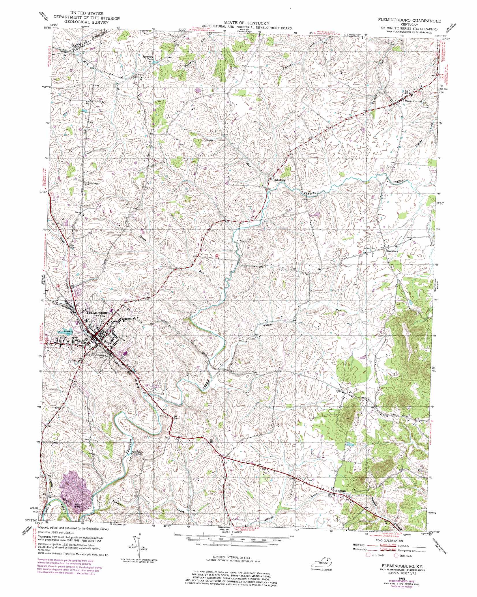
Flemingsburg Topo Map Kentucky
To zoom in, hover over the map of Flemingsburg
USGS Topo Quad 38083d6 - 1:24,000 scale
| Topo Map Name: | Flemingsburg |
| USGS Topo Quad ID: | 38083d6 |
| Print Size: | ca. 21 1/4" wide x 27" high |
| Southeast Coordinates: | 38.375° N latitude / 83.625° W longitude |
| Map Center Coordinates: | 38.4375° N latitude / 83.6875° W longitude |
| U.S. State: | KY |
| Filename: | o38083d6.jpg |
| Download Map JPG Image: | Flemingsburg topo map 1:24,000 scale |
| Map Type: | Topographic |
| Topo Series: | 7.5´ |
| Map Scale: | 1:24,000 |
| Source of Map Images: | United States Geological Survey (USGS) |
| Alternate Map Versions: |
Flemingsburg KY 1951, updated 1953 Download PDF Buy paper map Flemingsburg KY 1951, updated 1979 Download PDF Buy paper map Flemingsburg KY 1951, updated 1979 Download PDF Buy paper map Flemingsburg KY 2010 Download PDF Buy paper map Flemingsburg KY 2013 Download PDF Buy paper map Flemingsburg KY 2016 Download PDF Buy paper map |
1:24,000 Topo Quads surrounding Flemingsburg
Germantown |
Maysville West |
Maysville East |
Manchester Islands |
Concord |
Sardis |
Mays Lick |
Orangeburg |
Tollesboro |
Charters |
Cowan |
Elizaville |
Flemingsburg |
Burtonville |
Stricklett |
Moorefield |
Sherburne |
Hillsboro |
Plummers Landing |
Cranston |
Sharpsburg |
Owingsville |
Colfax |
Farmers |
Morehead |
> Back to 38083a1 at 1:100,000 scale
> Back to 38082a1 at 1:250,000 scale
> Back to U.S. Topo Maps home
Flemingsburg topo map: Gazetteer
Flemingsburg: Bridges
Double D Trestle elevation 283m 928′Flemingsburg: Crossings
Secrest Crossing elevation 276m 905′Flemingsburg: Lakes
Sycamore Lake elevation 271m 889′Flemingsburg: Populated Places
Beechburg elevation 272m 892′Bluebank elevation 269m 882′
Dalesburg elevation 264m 866′
Flemingsburg elevation 248m 813′
Mount Carmel elevation 269m 882′
Flemingsburg: Post Offices
Acme Post Office (historical) elevation 293m 961′Beechbry Post Office (historical) elevation 273m 895′
Dalesburg Post Office (historical) elevation 264m 866′
Mount Carmel Post Office (historical) elevation 268m 879′
Sutton Post Office (historical) elevation 287m 941′
Flemingsburg: Streams
Allison Creek elevation 231m 757′Cassidy Creek elevation 230m 754′
Logan Run elevation 250m 820′
Sleepy Run elevation 243m 797′
Town Branch elevation 235m 770′
Wilson Run elevation 237m 777′
Flemingsburg: Summits
Fox Mountain elevation 276m 905′Flemingsburg digital topo map on disk
Buy this Flemingsburg topo map showing relief, roads, GPS coordinates and other geographical features, as a high-resolution digital map file on DVD:
Western Virginia & Southern West Virginia
Buy digital topo maps: Western Virginia & Southern West Virginia