Whispering Pines Topo Map California
To zoom in, hover over the map of Whispering Pines
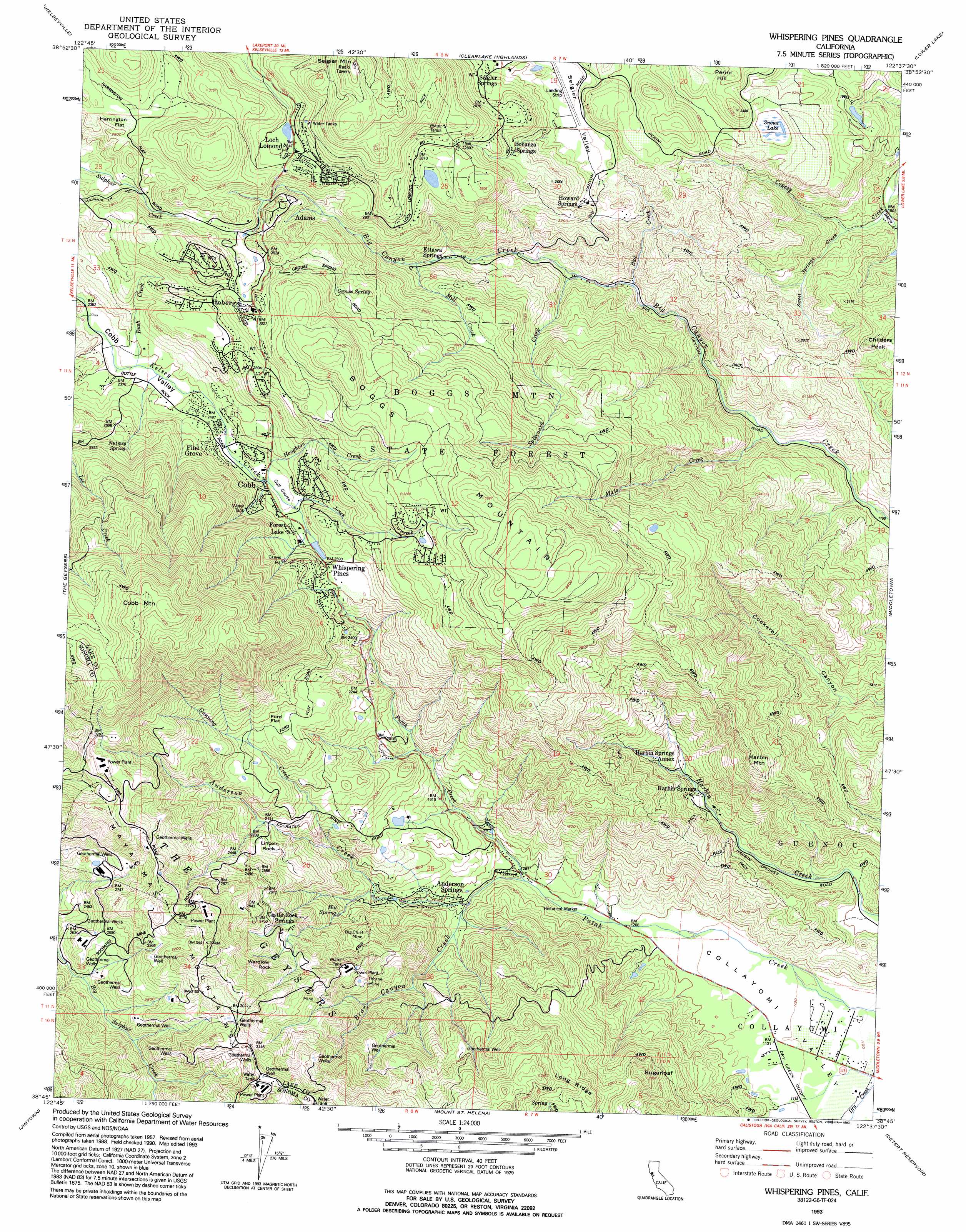
USGS Topo Quad 38122g6 - 1:24,000 scale
| Topo Map Name: | Whispering Pines |
| USGS Topo Quad ID: | 38122g6 |
| Print Size: | ca. 21 1/4" wide x 27" high |
| Southeast Coordinates: | 38.75° N latitude / 122.625° W longitude |
| Map Center Coordinates: | 38.8125° N latitude / 122.6875° W longitude |
| U.S. State: | CA |
| Filename: | o38122g6.jpg |
| Download Map JPG Image: | Whispering Pines topo map 1:24,000 scale |
| Map Type: | Topographic |
| Topo Series: | 7.5´ |
| Map Scale: | 1:24,000 |
| Source of Map Images: | United States Geological Survey (USGS) |
| Alternate Map Versions: |
Whispering Pines CA 1958, updated 1961 Download PDF Buy paper map Whispering Pines CA 1958, updated 1968 Download PDF Buy paper map Whispering Pines CA 1958, updated 1984 Download PDF Buy paper map Whispering Pines CA 1958, updated 1991 Download PDF Buy paper map Whispering Pines CA 1993, updated 1993 Download PDF Buy paper map Whispering Pines CA 1998, updated 2002 Download PDF Buy paper map Whispering Pines CA 2012 Download PDF Buy paper map Whispering Pines CA 2015 Download PDF Buy paper map |
1:24,000 Topo Quads surrounding Whispering Pines
Lakeport |
Lucerne |
Clearlake Oaks |
Benmore Canyon |
Wilbur Springs |
Highland Springs |
Kelseyville |
Clearlake |
Lower Lake |
Wilson Valley |
Asti |
The Geysers |
Whispering Pines |
Middletown |
Jericho Valley |
Geyserville |
Jimtown |
Mount Saint Helena |
Detert Reservoir |
Aetna Springs |
Guerneville |
Healdsburg |
Mark West Springs |
Calistoga |
Saint Helena |
> Back to 38122e1 at 1:100,000 scale
> Back to 38122a1 at 1:250,000 scale
> Back to U.S. Topo Maps home
Whispering Pines topo map: Gazetteer
Whispering Pines: Airports
Paul Hoberg Airport elevation 632m 2073′Paul Hoberg Airport elevation 649m 2129′
Whispering Pines: Flats
Ford Flat elevation 766m 2513′Harrington Flat elevation 868m 2847′
Whispering Pines: Forests
Boggs Mountain State Forest elevation 988m 3241′Whispering Pines: Lakes
Snows Lake elevation 665m 2181′Whispering Pines: Mines
Big Chief Mine elevation 585m 1919′Big Injun Mine elevation 745m 2444′
Thorne Mine elevation 622m 2040′
Whispering Pines: Pillars
Lincoln Rock elevation 652m 2139′Wardlow Rock elevation 905m 2969′
Whispering Pines: Populated Places
Adams elevation 858m 2814′Bonanza Springs elevation 794m 2604′
Castle Rock Springs elevation 716m 2349′
Cobb elevation 802m 2631′
Ettawa Springs elevation 601m 1971′
Forest Lake elevation 802m 2631′
Harbin Springs elevation 474m 1555′
Harbin Springs Annex elevation 520m 1706′
Hobergs elevation 919m 3015′
Howard Springs elevation 660m 2165′
Loch Lomond elevation 859m 2818′
Pine Grove elevation 768m 2519′
Seigler Springs elevation 686m 2250′
Whispering Pines elevation 805m 2641′
Whispering Pines: Post Offices
Adams Post Office (historical) elevation 858m 2814′Hobergs Post Office (historical) elevation 919m 3015′
Whispering Pines: Springs
Anderson Springs elevation 430m 1410′Anderson-Bull Spring elevation 920m 3018′
Grouse Spring elevation 906m 2972′
Nutmeg Spring elevation 841m 2759′
Whispering Pines: Streams
Anderson Creek elevation 402m 1318′Bad Creek elevation 475m 1558′
Bear Canyon Creek elevation 390m 1279′
Gunning Creek elevation 499m 1637′
Harris Creek elevation 464m 1522′
Houghton Creek elevation 759m 2490′
Jones Creek elevation 769m 2522′
Malo Creek elevation 387m 1269′
Mill Creek elevation 639m 2096′
Rush Creek elevation 721m 2365′
Spikenard Creek elevation 502m 1646′
Sweet Springs Creek elevation 468m 1535′
Whispering Pines: Summits
Boggs Mountain elevation 1139m 3736′Childers Peak elevation 655m 2148′
Cobb Mountain elevation 1440m 4724′
Harbin Mountain elevation 785m 2575′
Seigler Mountain elevation 1108m 3635′
Sugarloaf elevation 708m 2322′
Whispering Pines: Valleys
Cobb Valley elevation 716m 2349′Collayomi Valley elevation 340m 1115′
Whispering Pines digital topo map on disk
Buy this Whispering Pines topo map showing relief, roads, GPS coordinates and other geographical features, as a high-resolution digital map file on DVD: