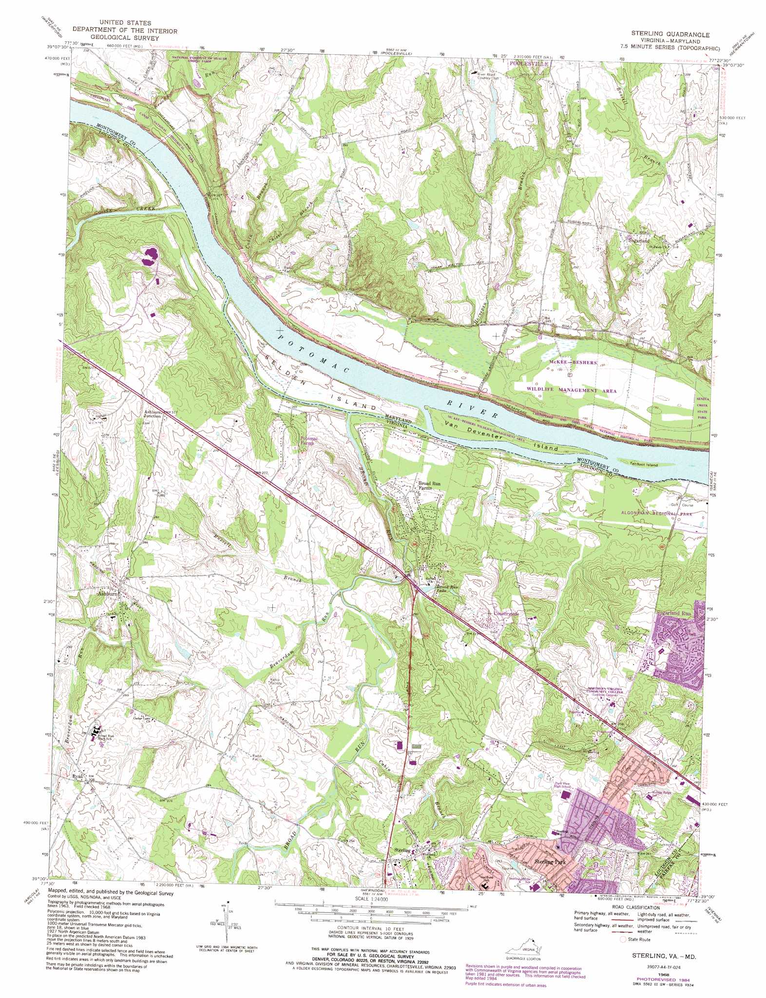
Sterling Topo Map Virginia
To zoom in, hover over the map of Sterling
USGS Topo Quad 39077a4 - 1:24,000 scale
| Topo Map Name: | Sterling |
| USGS Topo Quad ID: | 39077a4 |
| Print Size: | ca. 21 1/4" wide x 27" high |
| Southeast Coordinates: | 39° N latitude / 77.375° W longitude |
| Map Center Coordinates: | 39.0625° N latitude / 77.4375° W longitude |
| U.S. States: | VA, MD |
| Filename: | o39077a4.jpg |
| Download Map JPG Image: | Sterling topo map 1:24,000 scale |
| Map Type: | Topographic |
| Topo Series: | 7.5´ |
| Map Scale: | 1:24,000 |
| Source of Map Images: | United States Geological Survey (USGS) |
| Alternate Map Versions: |
Sterling VA 1952, updated 1954 Download PDF Buy paper map Sterling VA 1952, updated 1958 Download PDF Buy paper map Sterling VA 1952, updated 1965 Download PDF Buy paper map Sterling VA 1968, updated 1970 Download PDF Buy paper map Sterling VA 1968, updated 1973 Download PDF Buy paper map Sterling VA 1968, updated 1980 Download PDF Buy paper map Sterling VA 1968, updated 1984 Download PDF Buy paper map Sterling VA 1994, updated 1998 Download PDF Buy paper map Sterling VA 2011 Download PDF Buy paper map Sterling VA 2013 Download PDF Buy paper map Sterling VA 2016 Download PDF Buy paper map |
1:24,000 Topo Quads surrounding Sterling
Harpers Ferry |
Point Of Rocks |
Buckeystown |
Urbana |
Damascus |
Purcellville |
Waterford |
Poolesville |
Germantown |
Gaithersburg |
Lincoln |
Leesburg |
Sterling |
Seneca |
Rockville |
Middleburg |
Arcola |
Herndon |
Vienna |
Falls Church |
Thoroughfare Gap |
Gainesville |
Manassas |
Fairfax |
Annandale |
> Back to 39077a1 at 1:100,000 scale
> Back to 39076a1 at 1:250,000 scale
> Back to U.S. Topo Maps home
Sterling topo map: Gazetteer
Sterling: Bridges
Broad Run Aqueduct elevation 59m 193′Broad Run Bridge elevation 60m 196′
Sterling: Crossings
Edwards Ferry (historical) elevation 57m 187′Sterling: Dams
Lock 25 elevation 61m 200′Sterling: Islands
Selden Island elevation 60m 196′Tenfoot Island elevation 56m 183′
Van Deventer Island elevation 58m 190′
Sterling: Lakes
Alder Lake elevation 70m 229′Cedar Lake elevation 78m 255′
Tippecanoe Lake elevation 77m 252′
Sterling: Parks
Algonkian Regional Park elevation 63m 206′Ashburn Park elevation 77m 252′
Bles Park elevation 64m 209′
Briar Patch Park elevation 87m 285′
Claude Moore Park elevation 97m 318′
Elizabeth Mills Riverfront Park elevation 58m 190′
Greg Crittenden Memorial Park elevation 80m 262′
Kephart Bridge Landing elevation 70m 229′
Loudoun Heritage Farm Museum elevation 96m 314′
McKee-Beshers Wildlife Management Area elevation 60m 196′
Potomack Lakes Sportsplex elevation 61m 200′
Ray Muth Sr. Memorial Park elevation 69m 226′
Sterling: Populated Places
Ashburn elevation 90m 295′Ashburn Junction elevation 100m 328′
Ashburn Village elevation 85m 278′
Belmont Country Club elevation 104m 341′
Broad Run Farms elevation 70m 229′
Countryside elevation 91m 298′
Daysville (historical) elevation 93m 305′
Lansdowne Town Center elevation 93m 305′
Potomac Falls elevation 67m 219′
Potomac Farms elevation 84m 275′
Ryan elevation 93m 305′
Sterling elevation 89m 291′
Sterling Park elevation 113m 370′
Sugarland elevation 95m 311′
Sugarland Run elevation 88m 288′
University Center elevation 79m 259′
Sterling: Post Offices
Ashburn Post Office elevation 78m 255′Dulles Processing and Distribution Center elevation 79m 259′
Potomac Falls Branch Sterling Post Office elevation 92m 301′
Sterling: Reservoirs
Broad Run Lake elevation 68m 223′Potomac Valley Country Club Lake elevation 83m 272′
Walton Pond elevation 74m 242′
Sterling: Streams
Beaverdam Run elevation 62m 203′Broad Run elevation 57m 187′
Broad Run elevation 56m 183′
Cabin Branch elevation 64m 209′
Cabin Branch elevation 61m 200′
Cattail Branch elevation 59m 193′
Chisel Branch elevation 60m 196′
Church Mills Branch elevation 81m 265′
Goose Creek elevation 57m 187′
Horsepen Branch elevation 56m 183′
Russell Branch elevation 61m 200′
Sterling: Summits
Negro Hill elevation 100m 328′Sterling digital topo map on disk
Buy this Sterling topo map showing relief, roads, GPS coordinates and other geographical features, as a high-resolution digital map file on DVD:
Atlantic Coast (NY, NJ, PA, DE, MD, VA, NC)
Buy digital topo maps: Atlantic Coast (NY, NJ, PA, DE, MD, VA, NC)
 map DVD")