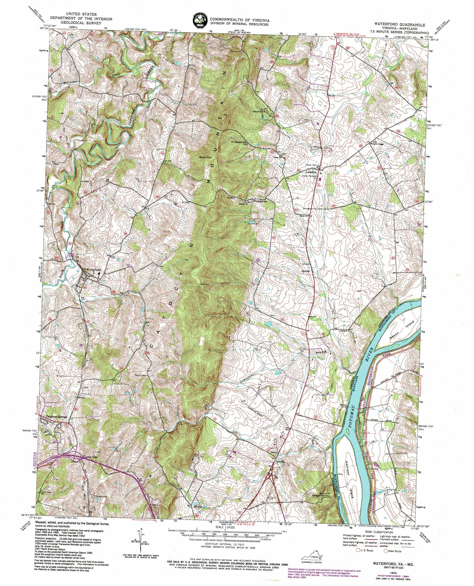
Waterford Topo Map Virginia
To zoom in, hover over the map of Waterford
USGS Topo Quad 39077b5 - 1:24,000 scale
| Topo Map Name: | Waterford |
| USGS Topo Quad ID: | 39077b5 |
| Print Size: | ca. 21 1/4" wide x 27" high |
| Southeast Coordinates: | 39.125° N latitude / 77.5° W longitude |
| Map Center Coordinates: | 39.1875° N latitude / 77.5625° W longitude |
| U.S. States: | VA, MD |
| Filename: | o39077b5.jpg |
| Download Map JPG Image: | Waterford topo map 1:24,000 scale |
| Map Type: | Topographic |
| Topo Series: | 7.5´ |
| Map Scale: | 1:24,000 |
| Source of Map Images: | United States Geological Survey (USGS) |
| Alternate Map Versions: |
Waterford VA 1952 Download PDF Buy paper map Waterford VA 1952, updated 1953 Download PDF Buy paper map Waterford VA 1952, updated 1960 Download PDF Buy paper map Waterford VA 1970, updated 1971 Download PDF Buy paper map Waterford VA 1970, updated 1976 Download PDF Buy paper map Waterford VA 1970, updated 1978 Download PDF Buy paper map Waterford VA 1970, updated 1984 Download PDF Buy paper map Waterford VA 2011 Download PDF Buy paper map Waterford VA 2013 Download PDF Buy paper map Waterford VA 2016 Download PDF Buy paper map |
1:24,000 Topo Quads surrounding Waterford
Shepherdstown |
Keedysville |
Middletown |
Frederick |
Walkersville |
Charles Town |
Harpers Ferry |
Point Of Rocks |
Buckeystown |
Urbana |
Round Hill |
Purcellville |
Waterford |
Poolesville |
Germantown |
Bluemont |
Lincoln |
Leesburg |
Sterling |
Seneca |
Rectortown |
Middleburg |
Arcola |
Herndon |
Vienna |
> Back to 39077a1 at 1:100,000 scale
> Back to 39076a1 at 1:250,000 scale
> Back to U.S. Topo Maps home
Waterford topo map: Gazetteer
Waterford: Bridges
Catoctin Creek Bridge elevation 87m 285′Waterford: Crossings
Potomac Crossing elevation 91m 298′Waterford: Islands
Harrison Island elevation 63m 206′Mason Island elevation 65m 213′
Waterford: Parks
Balls Bluff Regional Park elevation 75m 246′Lucketts Community Park elevation 98m 321′
Morven Park elevation 109m 357′
Temple Hall Farm Regional Park elevation 73m 239′
Waterford Historic District elevation 124m 406′
Waterford: Populated Places
Back Swamp elevation 90m 295′Clarks Gap elevation 192m 629′
Goresville elevation 85m 278′
Loyalty elevation 125m 410′
Lucketts elevation 97m 318′
Paeonian Springs elevation 172m 564′
Scattersville elevation 121m 396′
Shrys Store elevation 106m 347′
Stumptown elevation 120m 393′
Waterford elevation 131m 429′
Waterford: Post Offices
Paeonian Springs Post Office elevation 168m 551′Waterford Post Office elevation 115m 377′
Waterford: Streams
Limestone Branch elevation 56m 183′Milltown Creek elevation 85m 278′
North Fork Catoctin Creek elevation 100m 328′
South Fork Catoctin Creek elevation 100m 328′
Waterford: Summits
Bald Mountain elevation 235m 770′Waterford digital topo map on disk
Buy this Waterford topo map showing relief, roads, GPS coordinates and other geographical features, as a high-resolution digital map file on DVD:
Atlantic Coast (NY, NJ, PA, DE, MD, VA, NC)
Buy digital topo maps: Atlantic Coast (NY, NJ, PA, DE, MD, VA, NC)
 map DVD")