Antioch Topo Map Ohio
To zoom in, hover over the map of Antioch
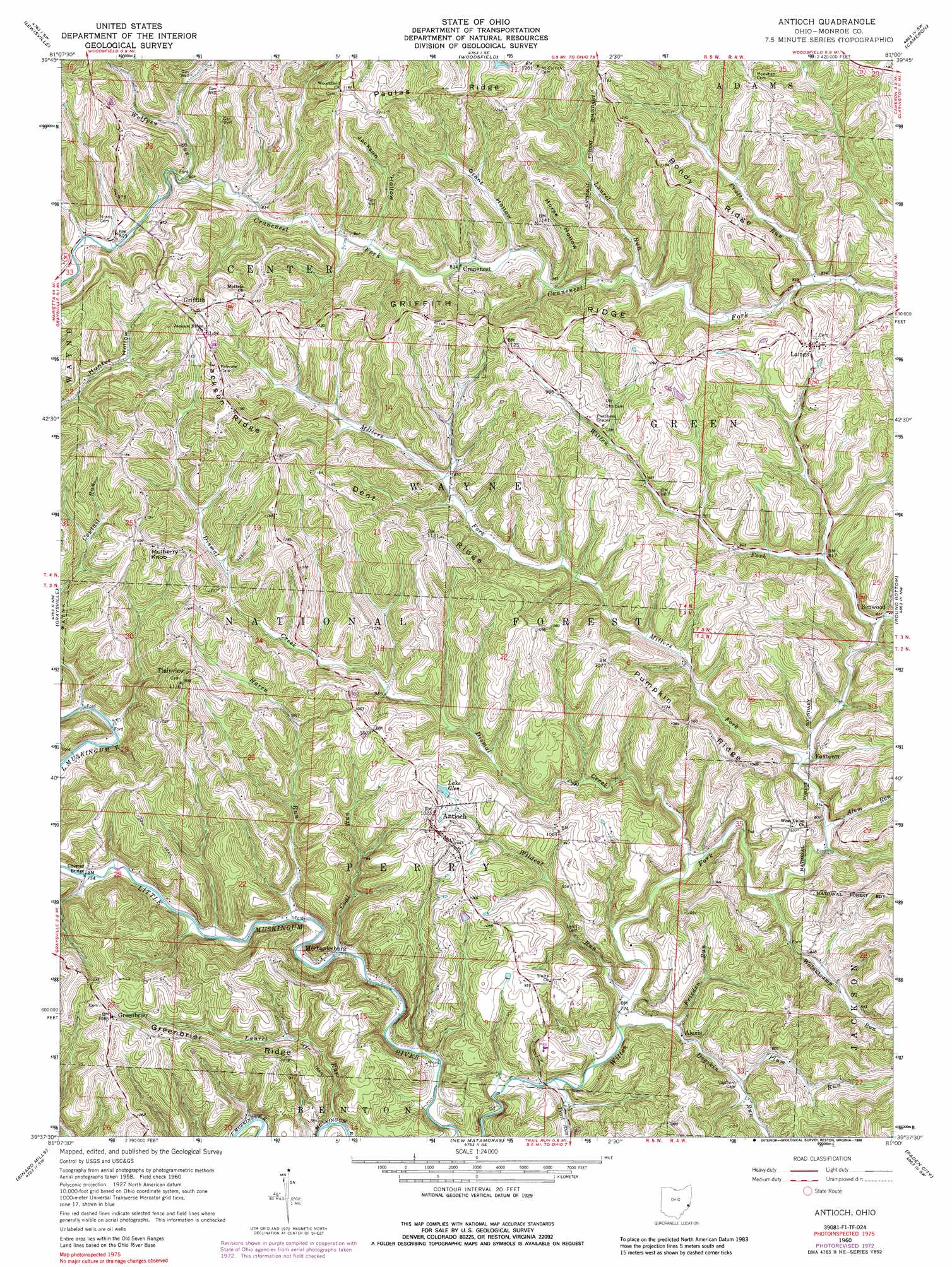
USGS Topo Quad 39081f1 - 1:24,000 scale
| Topo Map Name: | Antioch |
| USGS Topo Quad ID: | 39081f1 |
| Print Size: | ca. 21 1/4" wide x 27" high |
| Southeast Coordinates: | 39.625° N latitude / 81° W longitude |
| Map Center Coordinates: | 39.6875° N latitude / 81.0625° W longitude |
| U.S. State: | OH |
| Filename: | o39081f1.jpg |
| Download Map JPG Image: | Antioch topo map 1:24,000 scale |
| Map Type: | Topographic |
| Topo Series: | 7.5´ |
| Map Scale: | 1:24,000 |
| Source of Map Images: | United States Geological Survey (USGS) |
| Alternate Map Versions: |
Antioch OH 1960, updated 1961 Download PDF Buy paper map Antioch OH 1960, updated 1968 Download PDF Buy paper map Antioch OH 1960, updated 1973 Download PDF Buy paper map Antioch OH 1960, updated 1988 Download PDF Buy paper map Antioch OH 1994, updated 1998 Download PDF Buy paper map Antioch OH 2002, updated 2006 Download PDF Buy paper map Antioch OH 2011 Download PDF Buy paper map Antioch OH 2013 Download PDF Buy paper map Antioch OH 2016 Download PDF Buy paper map |
| FStopo: | US Forest Service topo Antioch is available: Download FStopo PDF Download FStopo TIF |
1:24,000 Topo Quads surrounding Antioch
Quaker City |
Barnesville |
Hunter |
Armstrongs Mills |
Businessburg |
Summerfield |
Lewisville |
Woodsfield |
Cameron |
Powhatan Point |
Stafford |
Graysville |
Antioch |
Round Bottom |
New Martinsville |
Dalzell |
Rinard Mills |
New Matamoras |
Paden City |
Porters Falls |
Belmont |
Raven Rock |
Bens Run |
Middlebourne |
Shirley |
> Back to 39081e1 at 1:100,000 scale
> Back to 39080a1 at 1:250,000 scale
> Back to U.S. Topo Maps home
Antioch topo map: Gazetteer
Antioch: Bridges
Foraker Bridge elevation 220m 721′Antioch: Populated Places
Alexis elevation 224m 734′Antioch elevation 326m 1069′
Benwood elevation 250m 820′
Cranenest elevation 254m 833′
Foxtown elevation 237m 777′
Greenbrier elevation 328m 1076′
Griffith elevation 349m 1145′
Laings elevation 312m 1023′
Mechanicsburg elevation 216m 708′
Plainview elevation 338m 1108′
Antioch: Post Offices
Alexis Post Office (historical) elevation 238m 780′Antioch Post Office elevation 326m 1069′
Benwood Post Office (historical) elevation 254m 833′
Griffith Post Office (historical) elevation 348m 1141′
Lainges Post Office elevation 311m 1020′
Plainview Post Office (historical) elevation 338m 1108′
Antioch: Reservoirs
Lake Glen elevation 293m 961′Antioch: Ridges
Bondy Ridge elevation 349m 1145′Dent Ridge elevation 359m 1177′
Greenbrier Ridge elevation 317m 1040′
Griffith Ridge elevation 347m 1138′
Jackson Ridge elevation 363m 1190′
Paulas Ridge elevation 370m 1213′
Pumpkin Ridge elevation 331m 1085′
Antioch: Streams
Alum Run elevation 233m 764′Coal Run elevation 218m 715′
Cowtail Run elevation 225m 738′
Dismal Creek elevation 226m 741′
Dogskin Run elevation 218m 715′
Frieden Run elevation 222m 728′
Haren Run elevation 222m 728′
Laurel Run elevation 210m 688′
Laurel Run elevation 255m 836′
Millers Fork elevation 235m 770′
Plum Run elevation 237m 777′
Pratts Run elevation 262m 859′
Trail Run elevation 216m 708′
Walnutcamp Run elevation 231m 757′
Wildcat Run elevation 220m 721′
Wolfpen Run elevation 243m 797′
Woods Run elevation 243m 797′
Antioch: Summits
Mulberry Knob elevation 370m 1213′Antioch: Valleys
Grant Hollow elevation 254m 833′Horse Hollow elevation 257m 843′
Jackson Hollow elevation 254m 833′
Antioch digital topo map on disk
Buy this Antioch topo map showing relief, roads, GPS coordinates and other geographical features, as a high-resolution digital map file on DVD:
 map DVD")