Powhatan Point Topo Map West Virginia
To zoom in, hover over the map of Powhatan Point
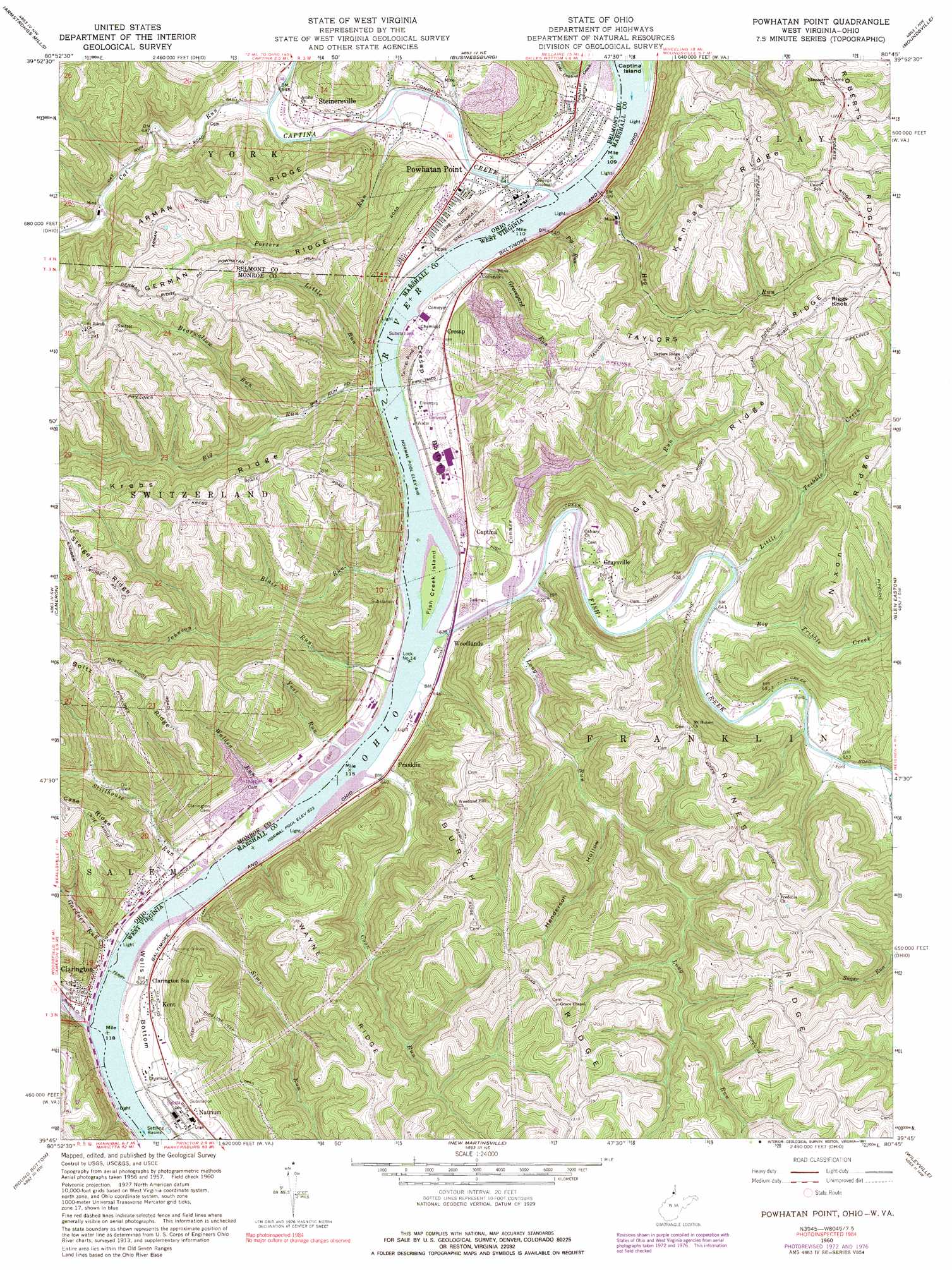
USGS Topo Quad 39080g7 - 1:24,000 scale
| Topo Map Name: | Powhatan Point |
| USGS Topo Quad ID: | 39080g7 |
| Print Size: | ca. 21 1/4" wide x 27" high |
| Southeast Coordinates: | 39.75° N latitude / 80.75° W longitude |
| Map Center Coordinates: | 39.8125° N latitude / 80.8125° W longitude |
| U.S. States: | WV, OH |
| Filename: | o39080g7.jpg |
| Download Map JPG Image: | Powhatan Point topo map 1:24,000 scale |
| Map Type: | Topographic |
| Topo Series: | 7.5´ |
| Map Scale: | 1:24,000 |
| Source of Map Images: | United States Geological Survey (USGS) |
| Alternate Map Versions: |
Powhatan Point OH 1960, updated 1961 Download PDF Buy paper map Powhatan Point OH 1960, updated 1965 Download PDF Buy paper map Powhatan Point OH 1960, updated 1973 Download PDF Buy paper map Powhatan Point OH 1960, updated 1977 Download PDF Buy paper map Powhatan Point OH 1960, updated 1991 Download PDF Buy paper map Powhatan Point OH 2011 Download PDF Buy paper map Powhatan Point OH 2013 Download PDF Buy paper map Powhatan Point OH 2016 Download PDF Buy paper map |
1:24,000 Topo Quads surrounding Powhatan Point
Bethesda |
St Clairsville |
Lansing |
Wheeling |
Valley Grove |
Hunter |
Armstrongs Mills |
Businessburg |
Moundsville |
Majorsville |
Woodsfield |
Cameron |
Powhatan Point |
Glen Easton |
Cameron |
Antioch |
Round Bottom |
New Martinsville |
Wileyville |
Littleton |
New Matamoras |
Paden City |
Porters Falls |
Pine Grove |
Big Run |
> Back to 39080e1 at 1:100,000 scale
> Back to 39080a1 at 1:250,000 scale
> Back to U.S. Topo Maps home
Powhatan Point topo map: Gazetteer
Powhatan Point: Bends
Cresap Bend elevation 196m 643′Cresap Bottom elevation 200m 656′
Wells Bottom elevation 198m 649′
Powhatan Point: Capes
Powhatan Point elevation 208m 682′Powhatan Point: Crossings
Slippery Ford elevation 196m 643′Powhatan Point: Dams
Mitchell Plant Bottom Ash Pond Dam elevation 190m 623′Quarto Mine Number Four Dam Number Five elevation 197m 646′
Quarto Mine Number Four Dam Number Four elevation 197m 646′
Quarto Mine Number Four Dam Number One elevation 198m 649′
Quarto Mine Number Four Dam Number Three elevation 199m 652′
Quarto Mine Number Four Dam Number Two elevation 197m 646′
Powhatan Point: Forests
Sunfish Creek State Forest elevation 333m 1092′Powhatan Point: Islands
Clines Island (historical) elevation 190m 623′Fish Creek Island elevation 191m 626′
Powhatan Point: Mines
Ireland Mine elevation 216m 708′Powhatan Point: Populated Places
Captina elevation 203m 666′Clarington elevation 193m 633′
Cresap elevation 210m 688′
Franklin elevation 202m 662′
Graysville elevation 196m 643′
Kent elevation 199m 652′
Powhatan Point elevation 208m 682′
Steinersville elevation 203m 666′
Stillhouse Run (historical) elevation 191m 626′
Woodlands elevation 195m 639′
Powhatan Point: Post Offices
Powhatan Point Post Office elevation 205m 672′Powhatan Point: Reservoirs
Quarto Mine Number Four Dam Number Five elevation 197m 646′Quarto Mine Number Four Dam Number Four elevation 197m 646′
Quarto Mine Number Four Dam Number One elevation 198m 649′
Quarto Mine Number Four Dam Number Three elevation 199m 652′
Quarto Mine Number Four Dam Number Two elevation 197m 646′
Powhatan Point: Ridges
Arman Ridge elevation 384m 1259′Boltz Ridge elevation 411m 1348′
Burch Ridge elevation 415m 1361′
Gatts Ridge elevation 387m 1269′
Kansas Ridge elevation 379m 1243′
Krebs Ridge elevation 391m 1282′
Nixon Ridge elevation 405m 1328′
Rines Ridge elevation 403m 1322′
Roberts Ridge elevation 402m 1318′
Steiger Ridge elevation 402m 1318′
Taylors Ridge elevation 379m 1243′
Wayne Ridge elevation 422m 1384′
Powhatan Point: Springs
Albert Kuhens Spring elevation 365m 1197′Homer Bulter Spring elevation 215m 705′
Joseph Kramer Spring elevation 356m 1167′
Lionel Persinger Spring elevation 235m 770′
Ralph Corley Spring elevation 369m 1210′
Stella Barlow Spring elevation 235m 770′
White Spring elevation 333m 1092′
William Hamilton Spring elevation 345m 1131′
Powhatan Point: Streams
Bearwallow Run elevation 212m 695′Big Run elevation 190m 623′
Big Tribble Creek elevation 192m 629′
Captina Creek elevation 190m 623′
Cat Run elevation 190m 623′
Conner Run elevation 190m 623′
Coon Run elevation 190m 623′
Fish Creek elevation 190m 623′
Gardner Run elevation 193m 633′
Graveyard Run elevation 192m 629′
Hog Run elevation 191m 626′
Johnson Run elevation 190m 623′
Little Run elevation 190m 623′
Little Tribble Creek elevation 194m 636′
Long Run elevation 190m 623′
Pig Run elevation 197m 646′
Porters Run elevation 189m 620′
Sims Run elevation 191m 626′
Stillhouse Run elevation 190m 623′
Sunfish Creek elevation 190m 623′
Walden Run elevation 190m 623′
Yost Run elevation 190m 623′
Powhatan Point: Summits
Riggs Knob elevation 435m 1427′Powhatan Point: Valleys
Henderson Hollow elevation 223m 731′Powhatan Point digital topo map on disk
Buy this Powhatan Point topo map showing relief, roads, GPS coordinates and other geographical features, as a high-resolution digital map file on DVD:
 map DVD")