Hunter Topo Map Ohio
To zoom in, hover over the map of Hunter
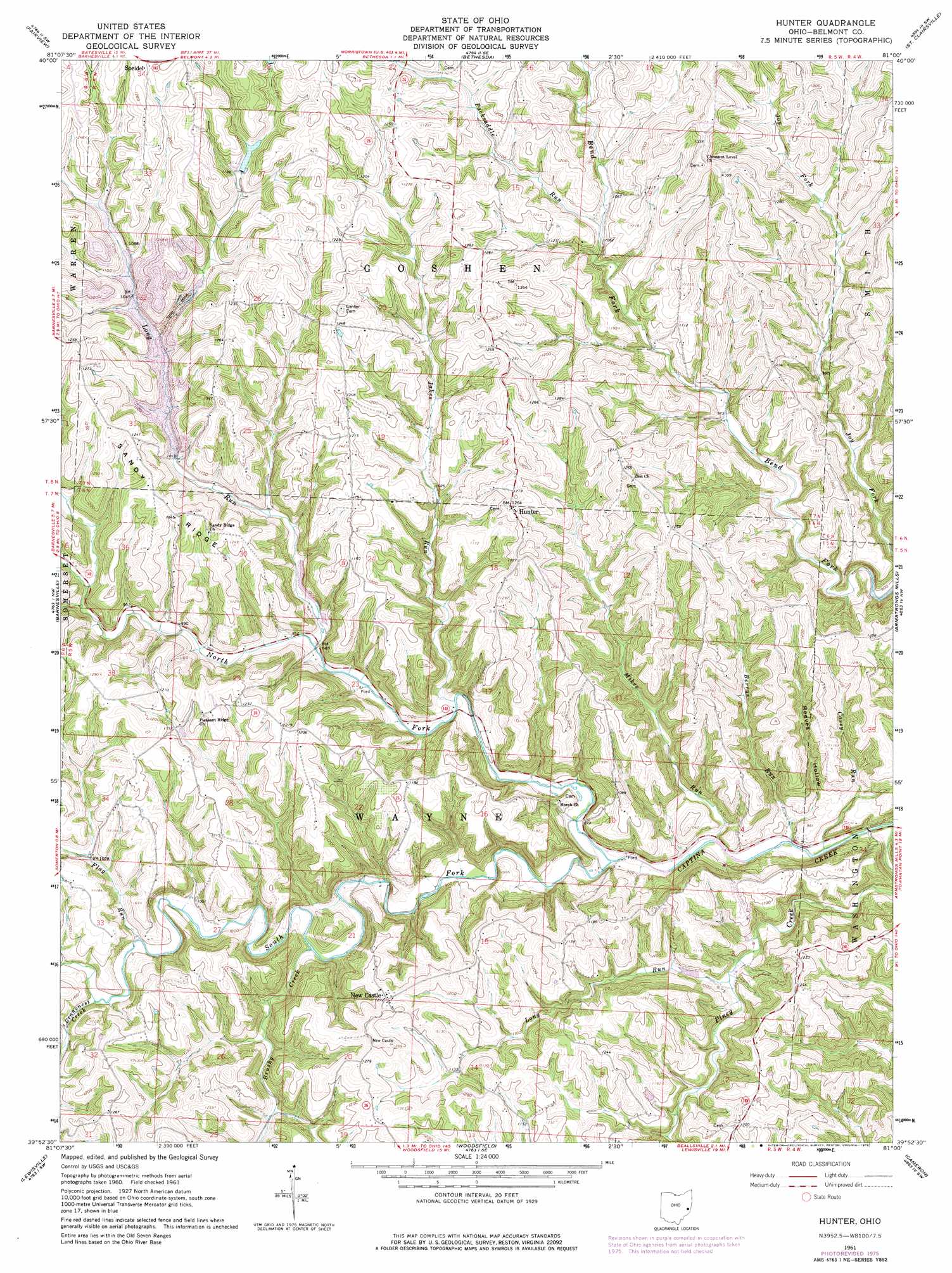
USGS Topo Quad 39081h1 - 1:24,000 scale
| Topo Map Name: | Hunter |
| USGS Topo Quad ID: | 39081h1 |
| Print Size: | ca. 21 1/4" wide x 27" high |
| Southeast Coordinates: | 39.875° N latitude / 81° W longitude |
| Map Center Coordinates: | 39.9375° N latitude / 81.0625° W longitude |
| U.S. State: | OH |
| Filename: | o39081h1.jpg |
| Download Map JPG Image: | Hunter topo map 1:24,000 scale |
| Map Type: | Topographic |
| Topo Series: | 7.5´ |
| Map Scale: | 1:24,000 |
| Source of Map Images: | United States Geological Survey (USGS) |
| Alternate Map Versions: |
Hunter OH 1961, updated 1963 Download PDF Buy paper map Hunter OH 1961, updated 1970 Download PDF Buy paper map Hunter OH 1975, updated 1976 Download PDF Buy paper map Hunter OH 1994, updated 1998 Download PDF Buy paper map Hunter OH 2010 Download PDF Buy paper map Hunter OH 2013 Download PDF Buy paper map Hunter OH 2016 Download PDF Buy paper map |
1:24,000 Topo Quads surrounding Hunter
Freeport |
Piedmont |
Flushing |
Harrisville |
Dillonvale |
Antrim |
Fairview |
Bethesda |
St Clairsville |
Lansing |
Quaker City |
Barnesville |
Hunter |
Armstrongs Mills |
Businessburg |
Summerfield |
Lewisville |
Woodsfield |
Cameron |
Powhatan Point |
Stafford |
Graysville |
Antioch |
Round Bottom |
New Martinsville |
> Back to 39081e1 at 1:100,000 scale
> Back to 39080a1 at 1:250,000 scale
> Back to U.S. Topo Maps home
Hunter topo map: Gazetteer
Hunter: Dams
Bethesda Sportsmans Club Pond Dam elevation 338m 1108′Hunter: Populated Places
Hunter elevation 375m 1230′New Castle elevation 386m 1266′
Hunter: Post Offices
Hunter Post Office (historical) elevation 360m 1181′Tacoma Post Office (historical) elevation 398m 1305′
Hunter: Reservoirs
Bethesda Sportsmans Club Pond elevation 338m 1108′Hunter: Ridges
Sandy Ridge elevation 388m 1272′Hunter: Streams
Berrys Run elevation 256m 839′Brushy Creek elevation 285m 935′
Casey Run elevation 261m 856′
Cranenest Creek elevation 314m 1030′
Flag Run elevation 299m 980′
Jakes Run elevation 280m 918′
Long Run elevation 283m 928′
Long Run elevation 286m 938′
Mikes Run elevation 259m 849′
North Fork Captina Creek elevation 259m 849′
Packsaddle Run elevation 316m 1036′
South Fork Captina Creek elevation 263m 862′
Hunter: Valleys
Reeves Hollow elevation 267m 875′Hunter digital topo map on disk
Buy this Hunter topo map showing relief, roads, GPS coordinates and other geographical features, as a high-resolution digital map file on DVD:
 map DVD")