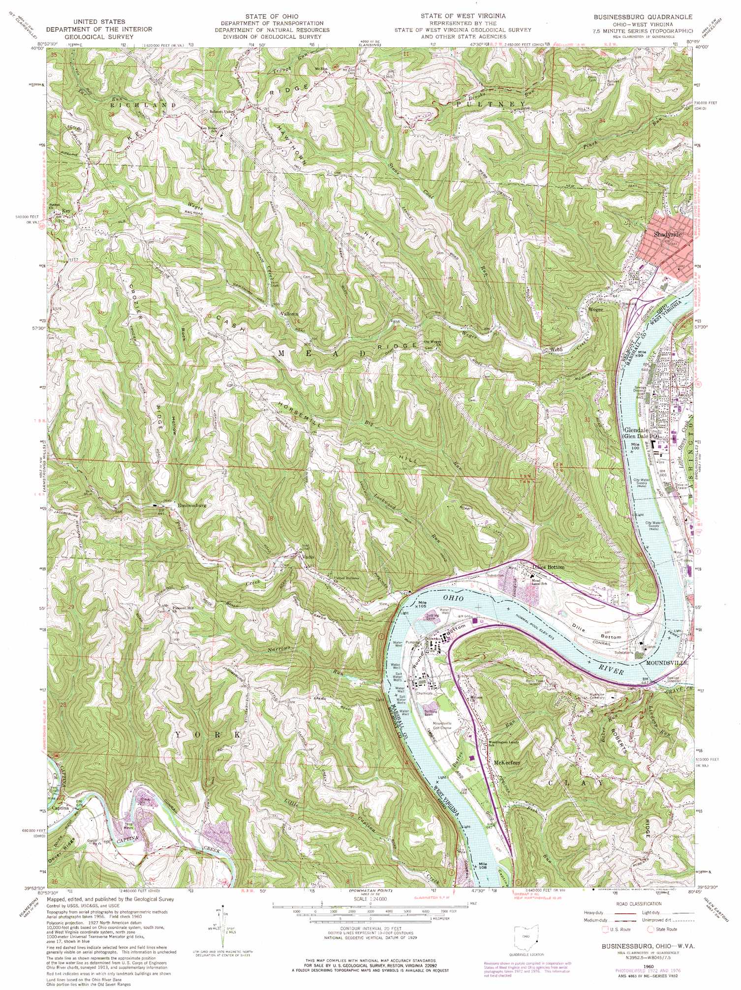
Businessburg Topo Map Ohio
To zoom in, hover over the map of Businessburg
USGS Topo Quad 39080h7 - 1:24,000 scale
| Topo Map Name: | Businessburg |
| USGS Topo Quad ID: | 39080h7 |
| Print Size: | ca. 21 1/4" wide x 27" high |
| Southeast Coordinates: | 39.875° N latitude / 80.75° W longitude |
| Map Center Coordinates: | 39.9375° N latitude / 80.8125° W longitude |
| U.S. States: | OH, WV |
| Filename: | o39080h7.jpg |
| Download Map JPG Image: | Businessburg topo map 1:24,000 scale |
| Map Type: | Topographic |
| Topo Series: | 7.5´ |
| Map Scale: | 1:24,000 |
| Source of Map Images: | United States Geological Survey (USGS) |
| Alternate Map Versions: |
Businessburg OH 1960, updated 1961 Download PDF Buy paper map Businessburg OH 1960, updated 1966 Download PDF Buy paper map Businessburg OH 1960, updated 1973 Download PDF Buy paper map Businessburg OH 1960, updated 1977 Download PDF Buy paper map Businessburg OH 1960, updated 1977 Download PDF Buy paper map Businessburg OH 2011 Download PDF Buy paper map Businessburg OH 2013 Download PDF Buy paper map Businessburg OH 2016 Download PDF Buy paper map |
1:24,000 Topo Quads surrounding Businessburg
Flushing |
Harrisville |
Dillonvale |
Tiltonsville |
Bethany |
Bethesda |
St Clairsville |
Lansing |
Wheeling |
Valley Grove |
Hunter |
Armstrongs Mills |
Businessburg |
Moundsville |
Majorsville |
Woodsfield |
Cameron |
Powhatan Point |
Glen Easton |
Cameron |
Antioch |
Round Bottom |
New Martinsville |
Wileyville |
Littleton |
> Back to 39080e1 at 1:100,000 scale
> Back to 39080a1 at 1:250,000 scale
> Back to U.S. Topo Maps home
Businessburg topo map: Gazetteer
Businessburg: Airports
Glendale Fokker Field elevation 198m 649′Moundsville Seaplane Base elevation 262m 859′
Businessburg: Bends
Dille Bottom elevation 191m 626′Round Bottom elevation 201m 659′
Businessburg: Bridges
Moundsville Bridge elevation 191m 626′Businessburg: Islands
Captina Island elevation 193m 633′Businessburg: Mines
Alexander Mine elevation 201m 659′Businessburg: Parks
Dowdell Park elevation 213m 698′Riverside Park elevation 196m 643′
Businessburg: Populated Places
Anvil elevation 399m 1309′Businessburg elevation 252m 826′
Captina elevation 207m 679′
Dilles Bottom elevation 212m 695′
Dunfee (historical) elevation 303m 994′
Glendale elevation 211m 692′
Heath elevation 220m 721′
Key elevation 387m 1269′
McKeefrey elevation 211m 692′
Shadyside elevation 210m 688′
Vadis elevation 213m 698′
Vallonia elevation 284m 931′
Webb elevation 214m 702′
Wegee elevation 204m 669′
Zitko Terrace elevation 245m 803′
Businessburg: Post Offices
Anvil Post Office (historical) elevation 391m 1282′Businessburg Post Office (historical) elevation 251m 823′
Captina Post Office (historical) elevation 207m 679′
Dilles Bottom Pot Office (historical) elevation 210m 688′
Glen Dale Post Office elevation 214m 702′
Heath Post Office (historical) elevation 260m 853′
Key Post Office (historical) elevation 386m 1266′
Vadis Post Office (historical) elevation 212m 695′
Vallonia Post Office (historical) elevation 294m 964′
Wegee Post Office (historical) elevation 202m 662′
Businessburg: Ridges
Cash Ridge elevation 385m 1263′Crozier Ridge elevation 402m 1318′
Key Ridge elevation 391m 1282′
Businessburg: Springs
Eugene Fitzwater Spring elevation 350m 1148′Businessburg: Streams
Baker Run elevation 191m 626′Big Run elevation 193m 633′
Butter Run elevation 191m 626′
Fish Run elevation 191m 626′
Grave Creek elevation 191m 626′
Lindsay Run elevation 193m 633′
Little Captina Creek elevation 191m 626′
Little Grave Creek elevation 192m 629′
Lockwood Run elevation 193m 633′
Narrows Run elevation 191m 626′
Pipe Creek elevation 191m 626′
Stone Coal Run elevation 229m 751′
Wegee Creek elevation 192m 629′
Businessburg: Summits
Hawthorn Hill elevation 397m 1302′Horsemill Hill elevation 378m 1240′
Businessburg: Valleys
Rock Hollow elevation 255m 836′Businessburg digital topo map on disk
Buy this Businessburg topo map showing relief, roads, GPS coordinates and other geographical features, as a high-resolution digital map file on DVD:
 map DVD")