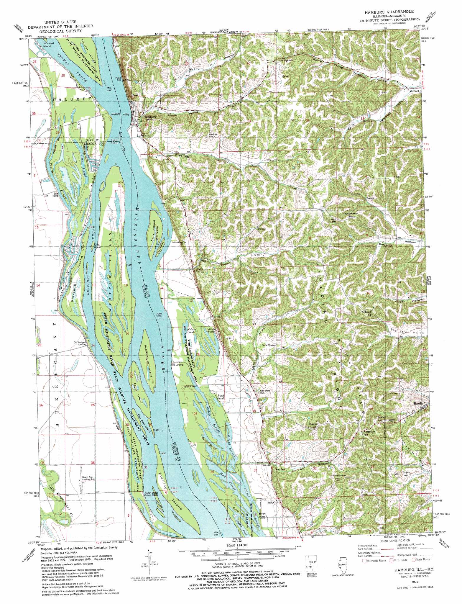
Hamburg Topo Map Illinois
To zoom in, hover over the map of Hamburg
USGS Topo Quad 39090b6 - 1:24,000 scale
| Topo Map Name: | Hamburg |
| USGS Topo Quad ID: | 39090b6 |
| Print Size: | ca. 21 1/4" wide x 27" high |
| Southeast Coordinates: | 39.125° N latitude / 90.625° W longitude |
| Map Center Coordinates: | 39.1875° N latitude / 90.6875° W longitude |
| U.S. States: | IL, MO |
| Filename: | o39090b6.jpg |
| Download Map JPG Image: | Hamburg topo map 1:24,000 scale |
| Map Type: | Topographic |
| Topo Series: | 7.5´ |
| Map Scale: | 1:24,000 |
| Source of Map Images: | United States Geological Survey (USGS) |
| Alternate Map Versions: |
Hamburg IL 1978, updated 1978 Download PDF Buy paper map Hamburg IL 1993, updated 1996 Download PDF Buy paper map Hamburg IL 2012 Download PDF Buy paper map Hamburg IL 2015 Download PDF Buy paper map |
1:24,000 Topo Quads surrounding Hamburg
Pleasant Hill West |
Pleasant Hill East |
Pearl West |
Pearl East |
Roodhouse West |
Clarksville |
Annada |
Pleasant Dale Valley |
Kampsville |
Carrollton |
Auburn |
Elsberry |
Hamburg |
Hardin |
Boyer Creek |
Okete |
Luckett Ridge |
Foley |
Nutwood |
Otterville |
Troy |
Maryknoll |
Winfield |
Brussels |
Grafton |
> Back to 39090a1 at 1:100,000 scale
> Back to 39090a1 at 1:250,000 scale
> Back to U.S. Topo Maps home
Hamburg topo map: Gazetteer
Hamburg: Airports
Beach Ann Landing Strip elevation 133m 436′Sloans Airport elevation 133m 436′
Hamburg: Crossings
Hamburg Ferry elevation 132m 433′Hamburg: Guts
Deer Slough elevation 132m 433′Dixon Slough elevation 132m 433′
Gilead Slough elevation 132m 433′
Middle Slough elevation 132m 433′
Mud Slough elevation 133m 436′
Mud Slough elevation 132m 433′
Prairie Slough elevation 132m 433′
Sand Slough elevation 132m 433′
Tremell Slough elevation 133m 436′
Hamburg: Islands
Eagle Island elevation 132m 433′Four Acre Island elevation 134m 439′
Kelly Island elevation 134m 439′
Kickapoo Island elevation 133m 436′
Mink Island elevation 135m 442′
Mozier Island elevation 134m 439′
Schwanigan Island elevation 132m 433′
Sterling Island elevation 133m 436′
Westport Island elevation 133m 436′
Hamburg: Lakes
Byrd Pond elevation 132m 433′Lamey Pond elevation 132m 433′
Nelson Pond elevation 132m 433′
Strator Pond elevation 133m 436′
Hamburg: Parks
Mark Twain National Wildlife Refuge elevation 132m 433′Reds Landing State Fish and Waterfowl Manage elevation 133m 436′
Upper Mississippi River State Wildlife Manag elevation 133m 436′
Hamburg: Populated Places
Birch Island elevation 132m 433′Hamburg elevation 135m 442′
Old Westport Landing elevation 132m 433′
Star City elevation 140m 459′
Hamburg: Ridges
Blue Ridge elevation 234m 767′Dividing Ridge elevation 239m 784′
Hamburg: Springs
Cave Spring elevation 162m 531′Hamburg: Streams
Indian Creek elevation 132m 433′Kickapoo Chute elevation 132m 433′
Thomas Chute elevation 133m 436′
Westport Chute elevation 132m 433′
Hamburg: Summits
Anderson Hill elevation 228m 748′Bobtail Hill elevation 232m 761′
Gaske Hill elevation 234m 767′
Kintown Hill elevation 238m 780′
Plummer Hill elevation 233m 764′
Rocky Hill elevation 238m 780′
Sugar Loaf elevation 205m 672′
Hamburg: Valleys
Gresham Hollow elevation 132m 433′Kintown Hollow elevation 142m 465′
Lost Hollow elevation 182m 597′
McNabb Hollow elevation 144m 472′
North Prong Irish Hollow elevation 144m 472′
North Prong Michael Hollow elevation 133m 436′
South Prong Irish Hollow elevation 144m 472′
South Prong Michael Hollow elevation 133m 436′
Hamburg digital topo map on disk
Buy this Hamburg topo map showing relief, roads, GPS coordinates and other geographical features, as a high-resolution digital map file on DVD: