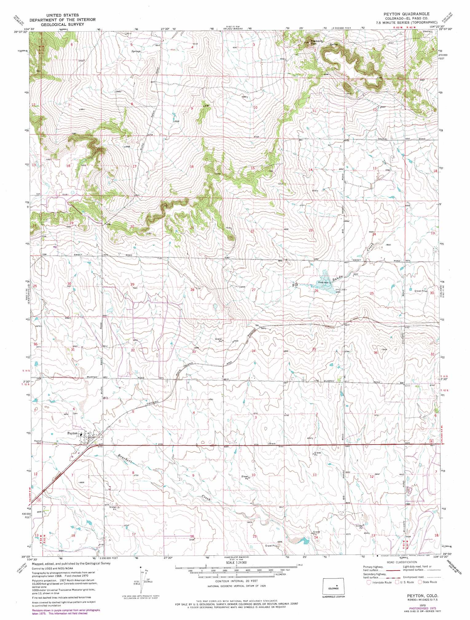
Peyton Topo Map Colorado
To zoom in, hover over the map of Peyton
USGS Topo Quad 39104a4 - 1:24,000 scale
| Topo Map Name: | Peyton |
| USGS Topo Quad ID: | 39104a4 |
| Print Size: | ca. 21 1/4" wide x 27" high |
| Southeast Coordinates: | 39° N latitude / 104.375° W longitude |
| Map Center Coordinates: | 39.0625° N latitude / 104.4375° W longitude |
| U.S. State: | CO |
| Filename: | o39104a4.jpg |
| Download Map JPG Image: | Peyton topo map 1:24,000 scale |
| Map Type: | Topographic |
| Topo Series: | 7.5´ |
| Map Scale: | 1:24,000 |
| Source of Map Images: | United States Geological Survey (USGS) |
| Alternate Map Versions: |
Peyton CO 1970, updated 1973 Download PDF Buy paper map Peyton CO 1970, updated 1973 Download PDF Buy paper map Peyton CO 1970, updated 1978 Download PDF Buy paper map Peyton CO 2010 Download PDF Buy paper map Peyton CO 2013 Download PDF Buy paper map Peyton CO 2016 Download PDF Buy paper map |
1:24,000 Topo Quads surrounding Peyton
Russellville Gulch |
Elizabeth |
Kiowa |
Big Gulch |
Bijou Sw |
Cherry Valley School |
Elbert |
Bijou Basin |
Fondis |
Ramah North |
Black Forest |
Eastonville |
Peyton |
Calhan |
Ramah South |
Falcon Nw |
Falcon |
Haegler Ranch |
Holcolm Hills |
Rush Nw |
Elsmere |
Corral Bluffs |
Ellicott |
Big Springs Ranch |
Yoder |
> Back to 39104a1 at 1:100,000 scale
> Back to 39104a1 at 1:250,000 scale
> Back to U.S. Topo Maps home
Peyton topo map: Gazetteer
Peyton: Airports
Combs Ranch Airport elevation 1998m 6555′Peyton: Dams
Big Sandy Creek Watershed S-1 Dam elevation 2031m 6663′J E McClelland Number 4 Dam elevation 1997m 6551′
Peyton: Populated Places
Peyton elevation 2078m 6817′Peyton: Reservoirs
Big Sandy Creek Watershed S-1 Reservoir elevation 2031m 6663′J E McClelland Reservoir Number 4 elevation 1997m 6551′
Peyton: Summits
Fremont Fort elevation 2166m 7106′Peyton digital topo map on disk
Buy this Peyton topo map showing relief, roads, GPS coordinates and other geographical features, as a high-resolution digital map file on DVD: