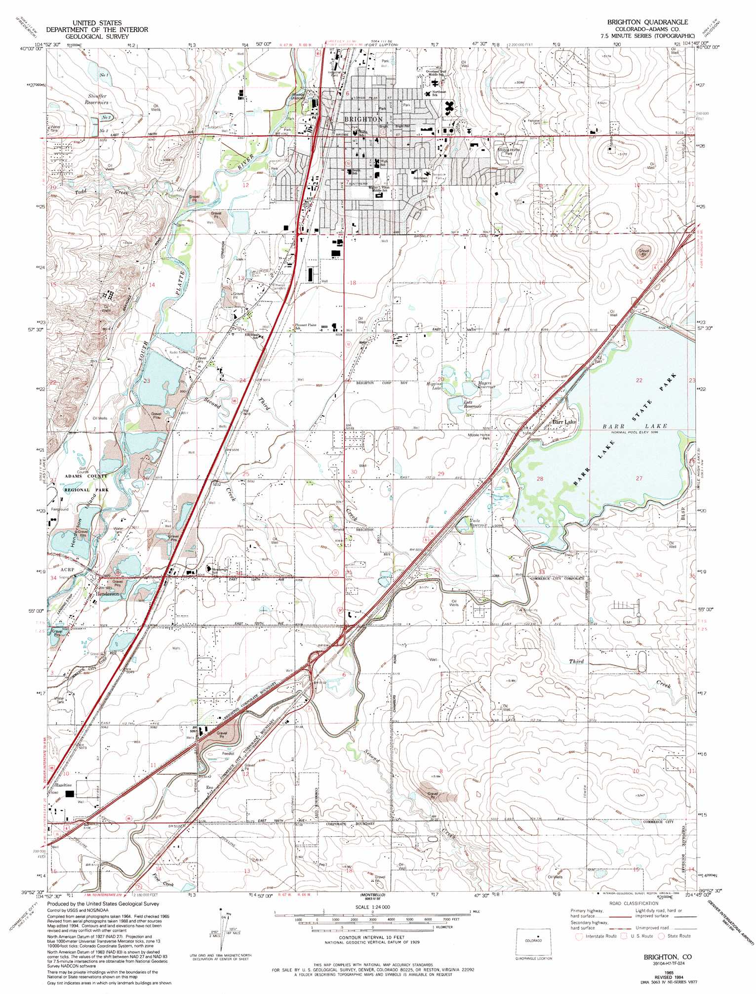
Brighton Topo Map Colorado
To zoom in, hover over the map of Brighton
USGS Topo Quad 39104h7 - 1:24,000 scale
| Topo Map Name: | Brighton |
| USGS Topo Quad ID: | 39104h7 |
| Print Size: | ca. 21 1/4" wide x 27" high |
| Southeast Coordinates: | 39.875° N latitude / 104.75° W longitude |
| Map Center Coordinates: | 39.9375° N latitude / 104.8125° W longitude |
| U.S. State: | CO |
| Filename: | o39104h7.jpg |
| Download Map JPG Image: | Brighton topo map 1:24,000 scale |
| Map Type: | Topographic |
| Topo Series: | 7.5´ |
| Map Scale: | 1:24,000 |
| Source of Map Images: | United States Geological Survey (USGS) |
| Alternate Map Versions: |
Brighton CO 1957, updated 1958 Download PDF Buy paper map Brighton CO 1957, updated 1958 Download PDF Buy paper map Brighton CO 1965, updated 1967 Download PDF Buy paper map Brighton CO 1965, updated 1967 Download PDF Buy paper map Brighton CO 1965, updated 1973 Download PDF Buy paper map Brighton CO 1965, updated 1973 Download PDF Buy paper map Brighton CO 1965, updated 1980 Download PDF Buy paper map Brighton CO 1965, updated 1986 Download PDF Buy paper map Brighton CO 1965, updated 1994 Download PDF Buy paper map Brighton CO 2010 Download PDF Buy paper map Brighton CO 2013 Download PDF Buy paper map Brighton CO 2016 Download PDF Buy paper map |
1:24,000 Topo Quads surrounding Brighton
Longmont |
Gowanda |
Platteville |
Milton Reservoir |
Klug Ranch |
Erie |
Frederick |
Fort Lupton |
Hudson |
Keenesburg |
Lafayette |
Eastlake |
Brighton |
Mile High Lakes |
Horse Creek |
Arvada |
Commerce City |
Sable |
Box Elder School |
Manila |
Fort Logan |
Englewood |
Fitzsimons |
Coal Creek |
Watkins |
> Back to 39104e1 at 1:100,000 scale
> Back to 39104a1 at 1:250,000 scale
> Back to U.S. Topo Maps home
Brighton topo map: Gazetteer
Brighton: Airports
Henderson Airport elevation 1531m 5022′Reasoner Airport elevation 1558m 5111′
Brighton: Canals
Fulton Ditch elevation 1535m 5036′McCann Ditch elevation 1512m 4960′
Brighton: Dams
Guthrie Number 1 Dam elevation 1539m 5049′Guthrie Number 2 Dam elevation 1548m 5078′
Higgins Dam elevation 1538m 5045′
Houck Number 1 Dam elevation 1577m 5173′
Lutz Dam elevation 1540m 5052′
Pikeview Dam elevation 1548m 5078′
Pikeview Dam elevation 1563m 5127′
Vail Dam elevation 1550m 5085′
Brighton: Flats
Henderson Island elevation 1525m 5003′Brighton: Mines
Adams Aggregate Incorporated Pit elevation 1522m 4993′Henderson Pit elevation 1529m 5016′
Kilgore-Atchison Pit elevation 1522m 4993′
Tee Pee Construction Company Pit elevation 1535m 5036′
Brighton: Parks
Benedict Park elevation 1528m 5013′Brighton: Populated Places
Barr Lake elevation 1558m 5111′Brighton elevation 1519m 4983′
Eno elevation 1561m 5121′
Henderson elevation 1531m 5022′
Todd Creek elevation 1540m 5052′
Brighton: Reservoirs
Barr Lake elevation 1555m 5101′Guthrie Reservoir Number 1 elevation 1539m 5049′
Guthrie Reservoir Number 2 elevation 1548m 5078′
Higgins Lake elevation 1538m 5045′
Houck Number 1 Reservoir elevation 1577m 5173′
Magers Reservoir elevation 1540m 5052′
Pikeview Reservoir elevation 1548m 5078′
Pikeview Reservoir Number 2 elevation 1563m 5127′
Skeel Reservoir Number 1 elevation 1539m 5049′
Stouffer Reservoir Number 1 elevation 1539m 5049′
Stouffer Reservoir Number 2 elevation 1546m 5072′
Stouffer Reservoir Number 3 elevation 1548m 5078′
Stouffer Reservoir Number 4 elevation 1554m 5098′
Stouffer Reservoirs elevation 1547m 5075′
Vail Reservoir elevation 1550m 5085′
Vaile Reservoir elevation 1550m 5085′
Brighton: Streams
First Creek elevation 1558m 5111′Second Creek elevation 1518m 4980′
Third Creek elevation 1515m 4970′
Todd Creek elevation 1515m 4970′
Brighton digital topo map on disk
Buy this Brighton topo map showing relief, roads, GPS coordinates and other geographical features, as a high-resolution digital map file on DVD: