Churchill Canyon Well Topo Map Nevada
To zoom in, hover over the map of Churchill Canyon Well
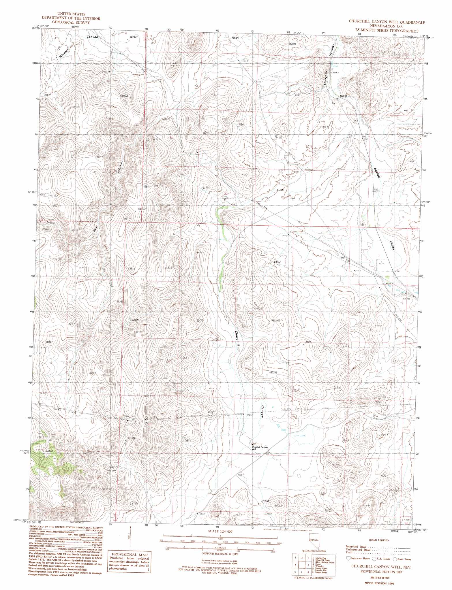
USGS Topo Quad 39119b3 - 1:24,000 scale
| Topo Map Name: | Churchill Canyon Well |
| USGS Topo Quad ID: | 39119b3 |
| Print Size: | ca. 21 1/4" wide x 27" high |
| Southeast Coordinates: | 39.125° N latitude / 119.25° W longitude |
| Map Center Coordinates: | 39.1875° N latitude / 119.3125° W longitude |
| U.S. State: | NV |
| Filename: | o39119b3.jpg |
| Download Map JPG Image: | Churchill Canyon Well topo map 1:24,000 scale |
| Map Type: | Topographic |
| Topo Series: | 7.5´ |
| Map Scale: | 1:24,000 |
| Source of Map Images: | United States Geological Survey (USGS) |
| Alternate Map Versions: |
Churchill Canyon Well NV 1987, updated 1987 Download PDF Buy paper map Churchill Canyon Well NV 1987, updated 1993 Download PDF Buy paper map Churchill Canyon Well NV 2011 Download PDF Buy paper map Churchill Canyon Well NV 2014 Download PDF Buy paper map |
1:24,000 Topo Quads surrounding Churchill Canyon Well
Chalk Hills |
Martin Canyon |
Stockton Well |
Silver Springs North |
Lahontan Dam |
Flowery Peak |
Misfits Flat |
Churchill Butte |
Silver Springs South |
Hooten Well |
Dayton |
Como |
Churchill Canyon Well |
Wabuska |
Parker Butte |
Mineral Peak |
Mount Como |
Lincoln Flat |
Mason Butte |
Hinkson Slough |
Mount Siegel |
Pine Nut Valley |
Artesia Lake |
Yerington |
Yerington Ne |
> Back to 39119a1 at 1:100,000 scale
> Back to 39118a1 at 1:250,000 scale
> Back to U.S. Topo Maps home
Churchill Canyon Well topo map: Gazetteer
Churchill Canyon Well: Gaps
Churchill Narrows elevation 1300m 4265′Churchill Canyon Well: Springs
Churchill Canyon Spring elevation 1366m 4481′Churchill Spring elevation 1392m 4566′
Churchill Canyon Well: Valleys
Churchill Canyon elevation 1309m 4294′Mill Canyon elevation 1303m 4274′
Churchill Canyon Well: Wells
Churchill Canyon Well elevation 1441m 4727′Churchill Canyon Well digital topo map on disk
Buy this Churchill Canyon Well topo map showing relief, roads, GPS coordinates and other geographical features, as a high-resolution digital map file on DVD: