Quogue Topo Map New York
To zoom in, hover over the map of Quogue
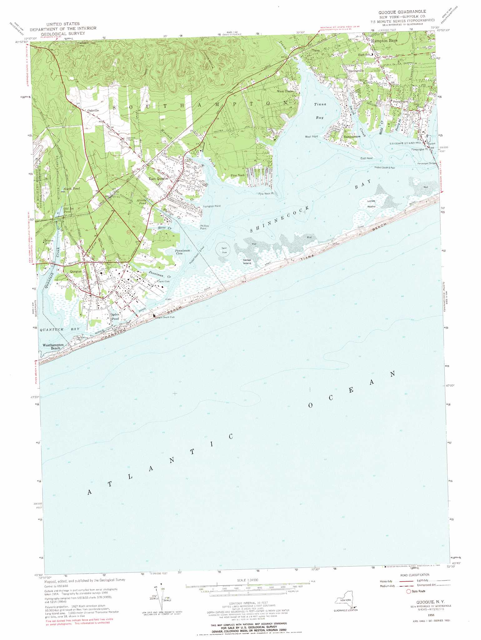
USGS Topo Quad 40072g5 - 1:24,000 scale
| Topo Map Name: | Quogue |
| USGS Topo Quad ID: | 40072g5 |
| Print Size: | ca. 21 1/4" wide x 27" high |
| Southeast Coordinates: | 40.75° N latitude / 72.5° W longitude |
| Map Center Coordinates: | 40.8125° N latitude / 72.5625° W longitude |
| U.S. State: | NY |
| Filename: | o40072g5.jpg |
| Download Map JPG Image: | Quogue topo map 1:24,000 scale |
| Map Type: | Topographic |
| Topo Series: | 7.5´ |
| Map Scale: | 1:24,000 |
| Source of Map Images: | United States Geological Survey (USGS) |
| Alternate Map Versions: |
Quogue NY 1947 Download PDF Buy paper map Quogue NY 1956, updated 1957 Download PDF Buy paper map Quogue NY 1956, updated 1966 Download PDF Buy paper map Quogue NY 2011 Download PDF Buy paper map Quogue NY 2013 Download PDF Buy paper map Quogue NY 2016 Download PDF Buy paper map |
1:24,000 Topo Quads surrounding Quogue
Mattituck Hills |
Southold |
Greenport |
||
Wading River |
Riverhead |
Mattituck |
Southampton |
Sag Harbor |
Moriches |
Eastport |
Quogue |
Shinnecock Inlet |
|
Pattersquash Island |
||||
> Back to 40072e1 at 1:100,000 scale
> Back to 40072a1 at 1:250,000 scale
> Back to U.S. Topo Maps home
Quogue topo map: Gazetteer
Quogue: Basins
Henrys Hollow elevation 28m 91′Quogue: Bays
Penniman Cove elevation 0m 0′Penniman Creek elevation 0m 0′
Penny Pond elevation 0m 0′
Phillips Creek elevation 0m 0′
Quantuck Bay elevation -2m -7′
Smith Creek elevation 0m 0′
Stone Creek elevation 0m 0′
Tiana Bay elevation 0m 0′
Wells Creek elevation 0m 0′
Quogue: Beaches
Hampton Beach elevation 2m 6′Tiana Beach elevation 3m 9′
Quogue: Bridges
Ponquogue Bridge elevation 0m 0′Quogue: Canals
Quogue Canal elevation 0m 0′Quogue: Capes
East Point elevation 0m 0′Hampton Point elevation 1m 3′
Phillips Point elevation 0m 0′
Pine Neck Point elevation 1m 3′
Ponquogue Point elevation 0m 0′
West Point elevation 0m 0′
Quogue: Islands
Lanes Island elevation 1m 3′Sedge Island elevation 0m 0′
Quogue: Lakes
Alcotts Pond elevation 2m 6′Ogden Pond elevation 0m 0′
Quogue: Parks
Quogue Waterfowl Refuge elevation 5m 16′Shinnecock County Park West elevation 3m 9′
Quogue: Populated Places
East Quogue elevation 4m 13′East Quogue Mobile Home Park elevation 8m 26′
Hampton Bays elevation 10m 32′
Hampton Bays Mobile Home Park elevation 10m 32′
Hampton Beach elevation 4m 13′
Oakville elevation 24m 78′
Pine Neck elevation 3m 9′
Ponquogue elevation 3m 9′
Quogue elevation 5m 16′
Rampasture elevation 4m 13′
Springville elevation 6m 19′
Tiana elevation 3m 9′
West Tiana elevation 9m 29′
Westhampton Beach elevation 2m 6′
Quogue: Post Offices
Quogue Post Office elevation 3m 9′Quogue: Reservoirs
North Pond elevation 3m 9′Old Ice Pond elevation 2m 6′
Quogue: Streams
Daves Creek elevation -1m -4′Quantuck Creek elevation 0m 0′
Tiana Creek elevation 0m 0′
Weesuck Creek elevation 0m 0′
Quogue: Summits
Flanders Hill elevation 70m 229′Quogue digital topo map on disk
Buy this Quogue topo map showing relief, roads, GPS coordinates and other geographical features, as a high-resolution digital map file on DVD:
Atlantic Coast (NY, NJ, PA, DE, MD, VA, NC)
Buy digital topo maps: Atlantic Coast (NY, NJ, PA, DE, MD, VA, NC)
 map DVD")