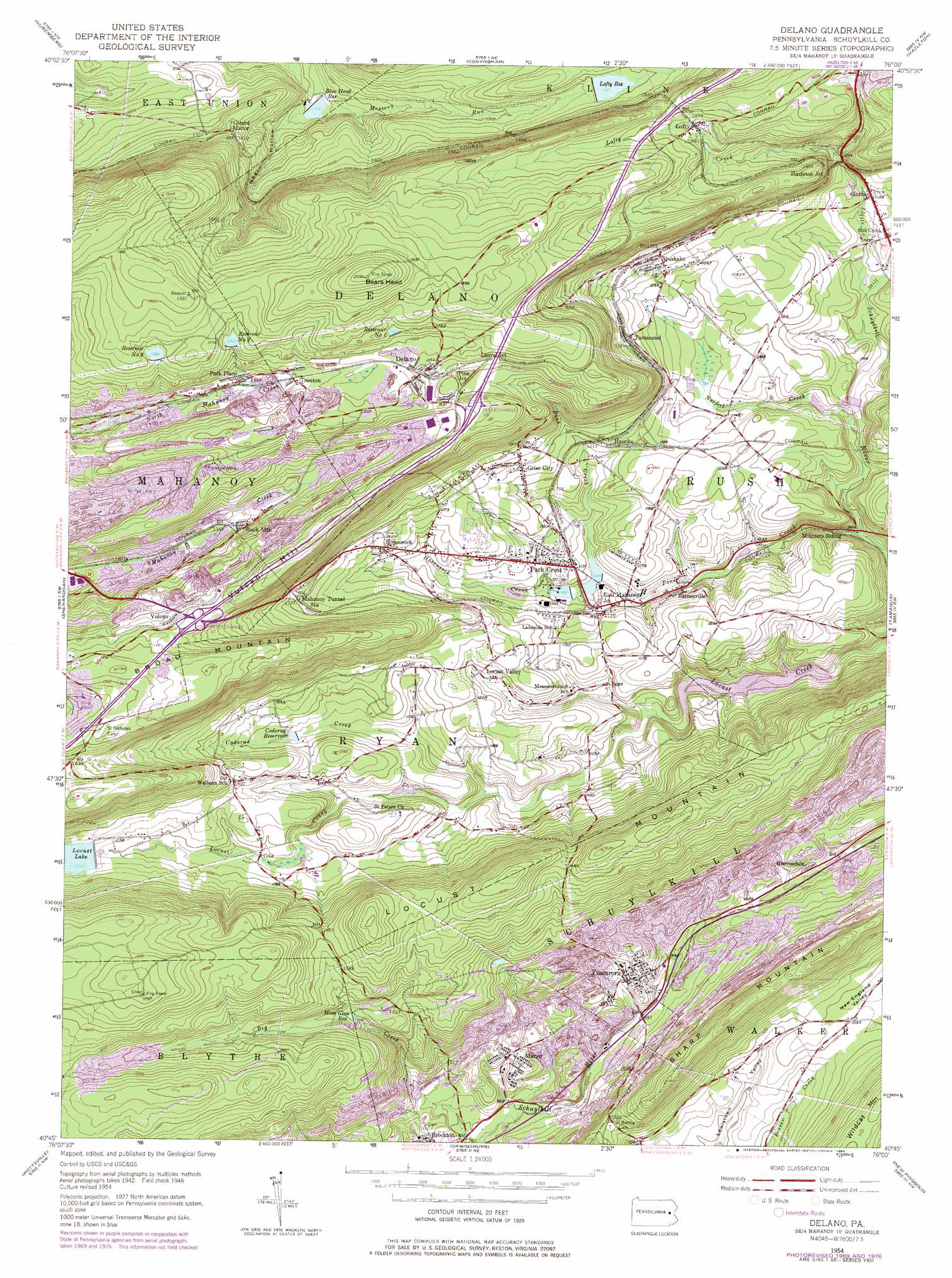
Delano Topo Map Pennsylvania
To zoom in, hover over the map of Delano
USGS Topo Quad 40076g1 - 1:24,000 scale
| Topo Map Name: | Delano |
| USGS Topo Quad ID: | 40076g1 |
| Print Size: | ca. 21 1/4" wide x 27" high |
| Southeast Coordinates: | 40.75° N latitude / 76° W longitude |
| Map Center Coordinates: | 40.8125° N latitude / 76.0625° W longitude |
| U.S. State: | PA |
| Filename: | o40076g1.jpg |
| Download Map JPG Image: | Delano topo map 1:24,000 scale |
| Map Type: | Topographic |
| Topo Series: | 7.5´ |
| Map Scale: | 1:24,000 |
| Source of Map Images: | United States Geological Survey (USGS) |
| Alternate Map Versions: |
Delano PA 1949 Download PDF Buy paper map Delano PA 1949 Download PDF Buy paper map Delano PA 1954, updated 1956 Download PDF Buy paper map Delano PA 1954, updated 1964 Download PDF Buy paper map Delano PA 1954, updated 1971 Download PDF Buy paper map Delano PA 1954, updated 1977 Download PDF Buy paper map Delano PA 1954, updated 1984 Download PDF Buy paper map Delano PA 1976, updated 1979 Download PDF Buy paper map Delano PA 1999, updated 2001 Download PDF Buy paper map Delano PA 2010 Download PDF Buy paper map Delano PA 2013 Download PDF Buy paper map Delano PA 2016 Download PDF Buy paper map |
1:24,000 Topo Quads surrounding Delano
Mifflinville |
Berwick |
Sybertsville |
Freeland |
White Haven |
Shumans |
Nuremberg |
Conyngham |
Hazleton |
Weatherly |
Ashland |
Shenandoah |
Delano |
Tamaqua |
Nesquehoning |
Minersville |
Pottsville |
Orwigsburg |
New Ringgold |
New Tripoli |
Swatara Hill |
Friedensburg |
Auburn |
Hamburg |
Kutztown |
> Back to 40076e1 at 1:100,000 scale
> Back to 40076a1 at 1:250,000 scale
> Back to U.S. Topo Maps home
Delano topo map: Gazetteer
Delano: Airports
Bendinsky Airport elevation 525m 1722′Wildcat Airport elevation 334m 1095′
Delano: Dams
Blue Head Dam elevation 344m 1128′Broad Mountain Dam elevation 506m 1660′
Codorus Dam elevation 354m 1161′
Hosensock Dam elevation 339m 1112′
Lakeside Dam elevation 330m 1082′
Lakeside Dam elevation 325m 1066′
Lakewood Dam elevation 330m 1082′
Little Schuylkill Dam elevation 316m 1036′
Locust Creek Dam elevation 304m 997′
Locust Lake Dam elevation 393m 1289′
Lofty Reservoir Dam elevation 424m 1391′
Mahanoy Dam Number Two elevation 533m 1748′
Neifert Creek Dam elevation 335m 1099′
Number One Dam elevation 363m 1190′
Park Place Dam Number Three elevation 539m 1768′
Swift Creek Dam elevation 355m 1164′
Delano: Parks
Tuscarora State Park elevation 329m 1079′Delano: Populated Places
Barnesville elevation 325m 1066′Buck Mountain elevation 416m 1364′
Delano elevation 503m 1650′
East Mahanoy Junction elevation 349m 1145′
Ginther elevation 361m 1184′
Girard Manor elevation 423m 1387′
Grier City elevation 381m 1250′
Haucks elevation 365m 1197′
Hazleton Junction elevation 440m 1443′
Hosensock elevation 377m 1236′
Laurel Junction elevation 494m 1620′
Locust Valley elevation 358m 1174′
Lofty elevation 469m 1538′
Maryd elevation 277m 908′
Park Crest elevation 342m 1122′
Park Place elevation 486m 1594′
Pine Junction elevation 492m 1614′
Quakake elevation 390m 1279′
Reevesdale elevation 295m 967′
Tamanend elevation 391m 1282′
Trenton elevation 492m 1614′
Tuscarora elevation 309m 1013′
Vulcan elevation 497m 1630′
Delano: Reservoirs
Blue Head Reservoir elevation 342m 1122′Broad Mountain Reservoir elevation 506m 1660′
Codorus Reservoir elevation 354m 1161′
Lakeside Park Reservoir elevation 330m 1082′
Locust Lake elevation 380m 1246′
Lofty Reservoir elevation 424m 1391′
Moss Glen Reservoir elevation 372m 1220′
Neifert Creek Impoundment elevation 335m 1099′
Number One Reservoir elevation 531m 1742′
Number Three Reservoir elevation 543m 1781′
Number Two Reservoir elevation 526m 1725′
Park Place Lake elevation 539m 1768′
Reservoir Number Two elevation 533m 1748′
Tuscarora Lake elevation 304m 997′
Delano: Streams
Codorus Creek elevation 331m 1085′East Branch Little Schuylkill River elevation 386m 1266′
Hosensock Creek elevation 328m 1076′
Lofty Creek elevation 385m 1263′
Moss Glen Creek elevation 251m 823′
Neifert Creek elevation 312m 1023′
Pine Creek elevation 290m 951′
Sinking Run elevation 443m 1453′
Still Creek elevation 329m 1079′
Delano: Summits
Bears Head elevation 634m 2080′Delano: Tunnels
Lofty Tunnel elevation 500m 1640′Delano: Valleys
Negro Hollow elevation 344m 1128′Delano digital topo map on disk
Buy this Delano topo map showing relief, roads, GPS coordinates and other geographical features, as a high-resolution digital map file on DVD:
Atlantic Coast (NY, NJ, PA, DE, MD, VA, NC)
Buy digital topo maps: Atlantic Coast (NY, NJ, PA, DE, MD, VA, NC)
 map DVD")