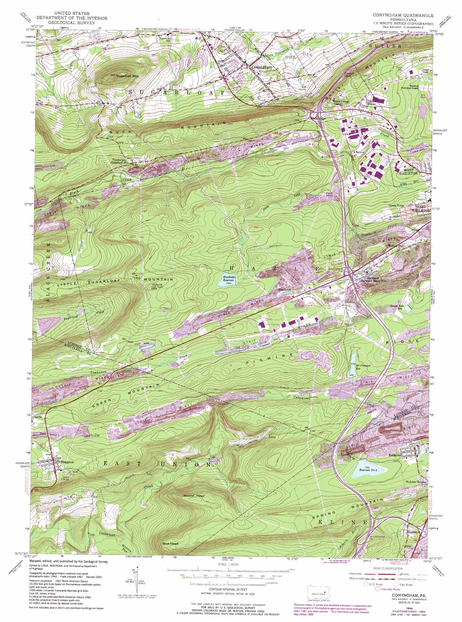
Conyngham Topo Map Pennsylvania
To zoom in, hover over the map of Conyngham
USGS Topo Quad 40076h1 - 1:24,000 scale
| Topo Map Name: | Conyngham |
| USGS Topo Quad ID: | 40076h1 |
| Print Size: | ca. 21 1/4" wide x 27" high |
| Southeast Coordinates: | 40.875° N latitude / 76° W longitude |
| Map Center Coordinates: | 40.9375° N latitude / 76.0625° W longitude |
| U.S. State: | PA |
| Filename: | o40076h1.jpg |
| Download Map JPG Image: | Conyngham topo map 1:24,000 scale |
| Map Type: | Topographic |
| Topo Series: | 7.5´ |
| Map Scale: | 1:24,000 |
| Source of Map Images: | United States Geological Survey (USGS) |
| Alternate Map Versions: |
Conyngham PA 1949 Download PDF Buy paper map Conyngham PA 1949 Download PDF Buy paper map Conyngham PA 1955, updated 1956 Download PDF Buy paper map Conyngham PA 1955, updated 1966 Download PDF Buy paper map Conyngham PA 1955, updated 1971 Download PDF Buy paper map Conyngham PA 1955, updated 1977 Download PDF Buy paper map Conyngham PA 1955, updated 1989 Download PDF Buy paper map Conyngham PA 1955, updated 1989 Download PDF Buy paper map Conyngham PA 1976, updated 1979 Download PDF Buy paper map Conyngham PA 2010 Download PDF Buy paper map Conyngham PA 2013 Download PDF Buy paper map Conyngham PA 2016 Download PDF Buy paper map |
1:24,000 Topo Quads surrounding Conyngham
Stillwater |
Shickshinny |
Nanticoke |
Wilkes-Barre West |
Wilkes-Barre East |
Mifflinville |
Berwick |
Sybertsville |
Freeland |
White Haven |
Shumans |
Nuremberg |
Conyngham |
Hazleton |
Weatherly |
Ashland |
Shenandoah |
Delano |
Tamaqua |
Nesquehoning |
Minersville |
Pottsville |
Orwigsburg |
New Ringgold |
New Tripoli |
> Back to 40076e1 at 1:100,000 scale
> Back to 40076a1 at 1:250,000 scale
> Back to U.S. Topo Maps home
Conyngham topo map: Gazetteer
Conyngham: Dams
Grape Run Dam elevation 525m 1722′Humboldt Dam elevation 538m 1765′
Lake Choctaw Dam elevation 386m 1266′
Lake Irena Dam elevation 458m 1502′
Lake Susquehanna Dam elevation 386m 1266′
Lower Mount Pleasant Dam elevation 508m 1666′
Upper Mount Pleasant Dam elevation 515m 1689′
Conyngham: Mines
Tomhicken Shaft Number Four elevation 366m 1200′Conyngham: Populated Places
Conyngham elevation 290m 951′Dippel Manor elevation 490m 1607′
Green Ridge elevation 510m 1673′
Haddock elevation 511m 1676′
Harwood elevation 512m 1679′
Hollars Hill elevation 507m 1663′
Humboldt elevation 529m 1735′
Kelayres elevation 531m 1742′
Sheppton elevation 500m 1640′
Tomhicken elevation 420m 1377′
Conyngham: Post Offices
Harwood Mines Post Office elevation 512m 1679′Sugarloaf Post Office elevation 420m 1377′
Conyngham: Reservoirs
Grape Run Reservoir elevation 525m 1722′Humboldt Reservoir elevation 535m 1755′
Lake Choctaw elevation 386m 1266′
Lake Irena elevation 458m 1502′
Lake Susquehanna elevation 386m 1266′
Mount Pleasant Reservoir elevation 508m 1666′
Number Eight Reservoir elevation 526m 1725′
Conyngham: Ridges
Council Crest elevation 517m 1696′Pismire Ridge elevation 561m 1840′
Conyngham: Streams
Cranberry Creek elevation 445m 1459′Cross Run elevation 497m 1630′
Hunkydory Creek elevation 515m 1689′
Long Run elevation 468m 1535′
Messers Run elevation 321m 1053′
Spies Run elevation 361m 1184′
Stony Creek elevation 442m 1450′
Wolffs Run elevation 523m 1715′
Conyngham: Summits
Blue Head elevation 557m 1827′Butler Mountain elevation 524m 1719′
Little Sugarloaf Mountain elevation 518m 1699′
Round Head elevation 556m 1824′
Sugarloaf Mountain elevation 511m 1676′
Conyngham: Swamps
Horse Shoe Swamp elevation 525m 1722′Conyngham digital topo map on disk
Buy this Conyngham topo map showing relief, roads, GPS coordinates and other geographical features, as a high-resolution digital map file on DVD:
Atlantic Coast (NY, NJ, PA, DE, MD, VA, NC)
Buy digital topo maps: Atlantic Coast (NY, NJ, PA, DE, MD, VA, NC)
 map DVD")