Wilkes-Barre East Topo Map Pennsylvania
To zoom in, hover over the map of Wilkes-Barre East
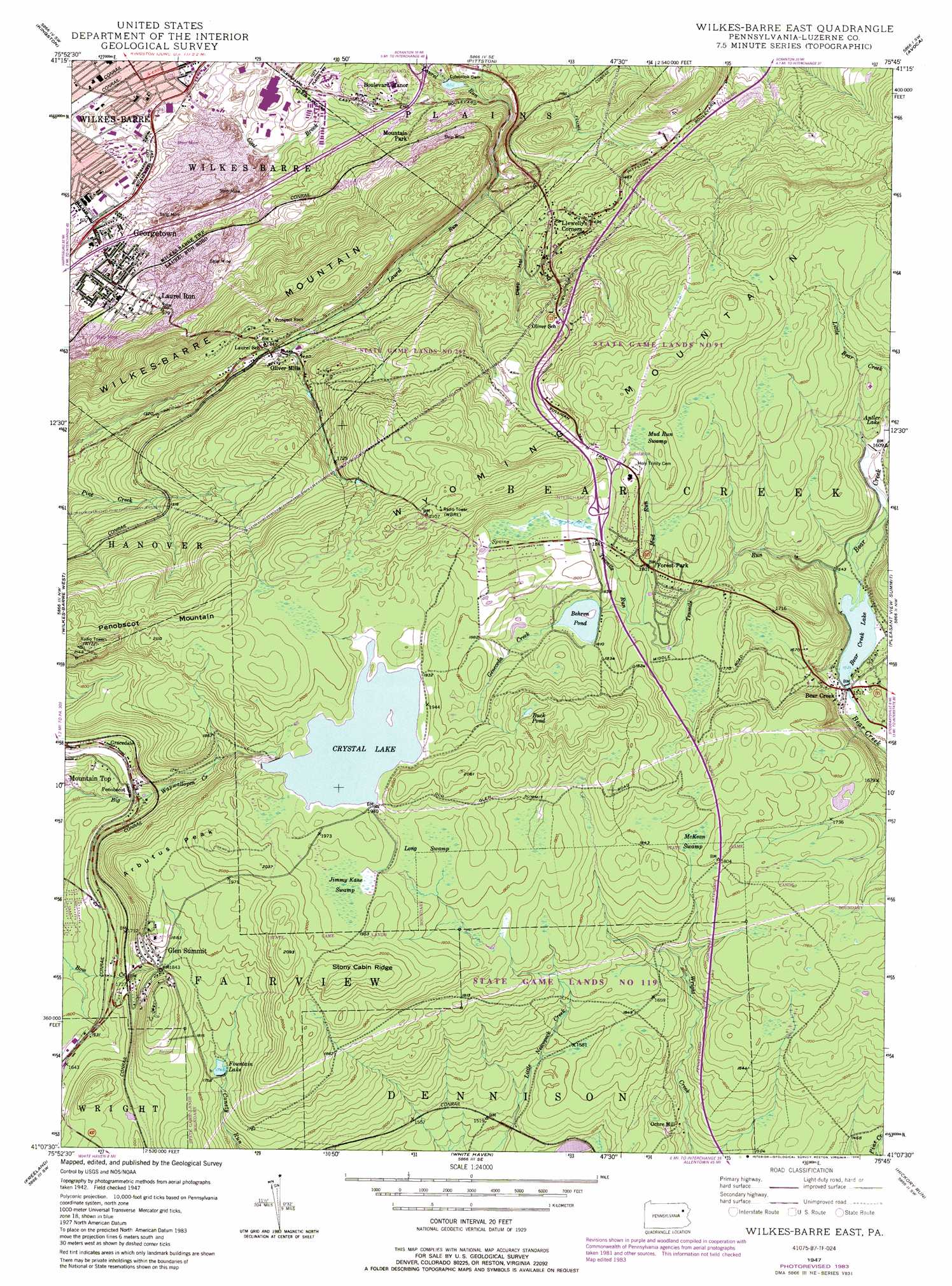
USGS Topo Quad 41075b7 - 1:24,000 scale
| Topo Map Name: | Wilkes-Barre East |
| USGS Topo Quad ID: | 41075b7 |
| Print Size: | ca. 21 1/4" wide x 27" high |
| Southeast Coordinates: | 41.125° N latitude / 75.75° W longitude |
| Map Center Coordinates: | 41.1875° N latitude / 75.8125° W longitude |
| U.S. State: | PA |
| Filename: | o41075b7.jpg |
| Download Map JPG Image: | Wilkes-Barre East topo map 1:24,000 scale |
| Map Type: | Topographic |
| Topo Series: | 7.5´ |
| Map Scale: | 1:24,000 |
| Source of Map Images: | United States Geological Survey (USGS) |
| Alternate Map Versions: |
Wilkes-Barre East PA 1947, updated 1959 Download PDF Buy paper map Wilkes-Barre East PA 1947, updated 1966 Download PDF Buy paper map Wilkes-Barre East PA 1947, updated 1969 Download PDF Buy paper map Wilkes-Barre East PA 1947, updated 1974 Download PDF Buy paper map Wilkes-Barre East PA 1947, updated 1978 Download PDF Buy paper map Wilkes-Barre East PA 1947, updated 1984 Download PDF Buy paper map Wilkes-Barre East PA 1947, updated 1988 Download PDF Buy paper map Wilkes-Barre East PA 1950 Download PDF Buy paper map Wilkes-Barre East PA 1950 Download PDF Buy paper map Wilkes-Barre East PA 1976, updated 1979 Download PDF Buy paper map Wilkes-Barre East PA 1994, updated 1995 Download PDF Buy paper map Wilkes-Barre East PA 1999, updated 2002 Download PDF Buy paper map Wilkes-Barre East PA 2010 Download PDF Buy paper map Wilkes-Barre East PA 2013 Download PDF Buy paper map Wilkes-Barre East PA 2016 Download PDF Buy paper map |
1:24,000 Topo Quads surrounding Wilkes-Barre East
Noxen |
Center Moreland |
Ransom |
Scranton |
Olyphant |
Harveys Lake |
Kingston |
Pittston |
Avoca |
Moscow |
Nanticoke |
Wilkes-Barre West |
Wilkes-Barre East |
Pleasant View Summit |
Thornhurst |
Sybertsville |
Freeland |
White Haven |
Hickory Run |
Blakeslee |
Conyngham |
Hazleton |
Weatherly |
Christmans |
Pohopoco Mountain |
> Back to 41075a1 at 1:100,000 scale
> Back to 41074a1 at 1:250,000 scale
> Back to U.S. Topo Maps home
Wilkes-Barre East topo map: Gazetteer
Wilkes-Barre East: Airports
Ballywick Airport elevation 555m 1820′Wilkes-Barre East: Crossings
Pennsylvania Turnpike Interchange 36 elevation 567m 1860′Wilkes-Barre East: Dams
Bear Creek Dam elevation 464m 1522′Colebrook Dam elevation 258m 846′
Crystal Lake Dam elevation 589m 1932′
Eikes Pond Dam elevation 549m 1801′
Laurel Run Number Two Dam elevation 256m 839′
Wilkes-Barre East: Falls
Whirlpool Canyon Falls elevation 382m 1253′Wilkes-Barre East: Lakes
Buck Pond elevation 606m 1988′Wilkes-Barre East: Parks
Mountain Park elevation 323m 1059′State Game Lands Number 119 elevation 494m 1620′
State Game Lands Number 292 elevation 534m 1751′
Wilkes-Barre East: Pillars
Prospect Rock elevation 421m 1381′Wilkes-Barre East: Populated Places
Bear Creek Village elevation 465m 1525′Boulevard Manor elevation 276m 905′
Forest Park elevation 552m 1811′
Georgetown elevation 213m 698′
Glen Summit elevation 561m 1840′
Gracedale elevation 502m 1646′
Laurel Run elevation 272m 892′
Liewellyn Corners elevation 421m 1381′
Llewellyn Corners elevation 454m 1489′
Ochre Mill elevation 450m 1476′
Oliver Mills elevation 433m 1420′
Penobscot elevation 497m 1630′
Wilkes-Barre East: Post Offices
Glen Summit Post Office (historical) elevation 561m 1840′Glen Summit Springs Post Office (historical) elevation 498m 1633′
Wilkes-Barre East: Reservoirs
Antler Lake elevation 484m 1587′Bear Creek Lake elevation 464m 1522′
Behren Pond elevation 549m 1801′
Crystal Lake elevation 592m 1942′
Fountain Lake elevation 532m 1745′
Meadow Run Lake elevation 256m 839′
Wilkes-Barre East: Ridges
Stony Cabin Ridge elevation 630m 2066′Wilkes-Barre East: Streams
Geneceda Creek elevation 540m 1771′Mud Run elevation 537m 1761′
Tenmile Run elevation 465m 1525′
Wilkes-Barre East: Summits
Arbutus Peak elevation 595m 1952′Wyoming Mountain elevation 618m 2027′
Wilkes-Barre East: Swamps
Jimmy Kane Swamp elevation 595m 1952′Long Swamp elevation 583m 1912′
McKean Swamp elevation 546m 1791′
Mud Run Swamp elevation 583m 1912′
Wilkes-Barre East: Valleys
Deep Hollow elevation 404m 1325′Wilkes-Barre East digital topo map on disk
Buy this Wilkes-Barre East topo map showing relief, roads, GPS coordinates and other geographical features, as a high-resolution digital map file on DVD:
New York, Vermont, Connecticut & Western Massachusetts
Buy digital topo maps: New York, Vermont, Connecticut & Western Massachusetts