Bluffton Topo Map Ohio
To zoom in, hover over the map of Bluffton
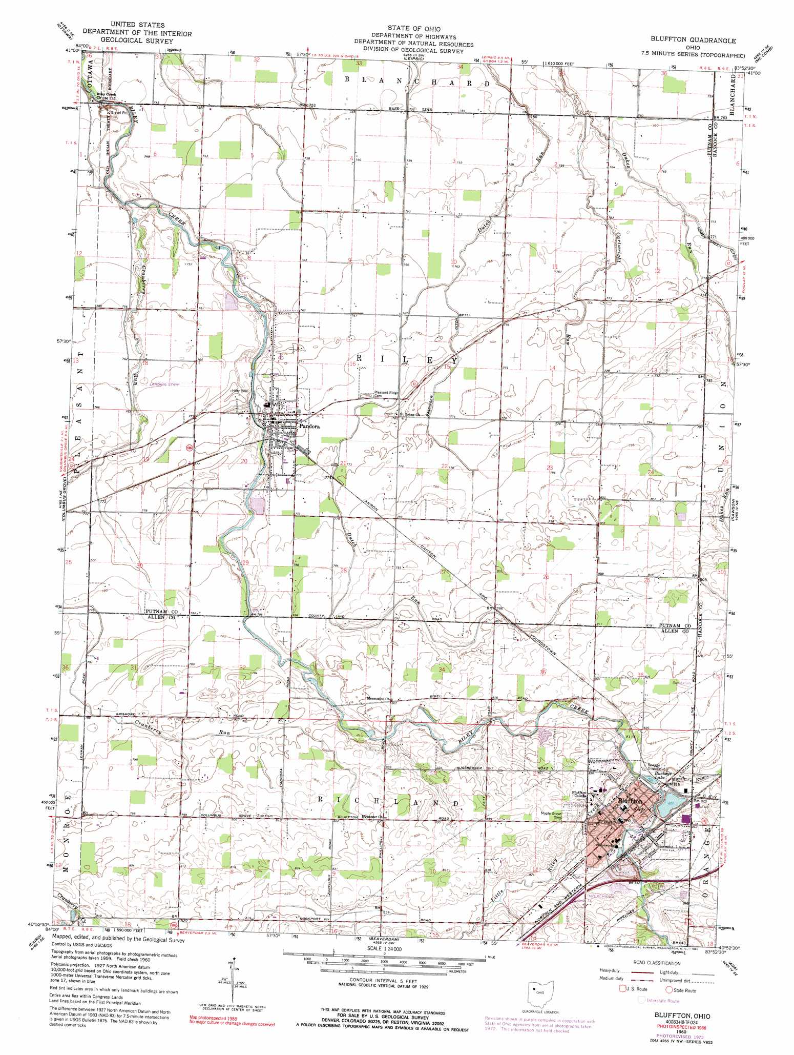
USGS Topo Quad 40083h8 - 1:24,000 scale
| Topo Map Name: | Bluffton |
| USGS Topo Quad ID: | 40083h8 |
| Print Size: | ca. 21 1/4" wide x 27" high |
| Southeast Coordinates: | 40.875° N latitude / 83.875° W longitude |
| Map Center Coordinates: | 40.9375° N latitude / 83.9375° W longitude |
| U.S. State: | OH |
| Filename: | o40083h8.jpg |
| Download Map JPG Image: | Bluffton topo map 1:24,000 scale |
| Map Type: | Topographic |
| Topo Series: | 7.5´ |
| Map Scale: | 1:24,000 |
| Source of Map Images: | United States Geological Survey (USGS) |
| Alternate Map Versions: |
Bluffton OH 1960, updated 1961 Download PDF Buy paper map Bluffton OH 1960, updated 1973 Download PDF Buy paper map Bluffton OH 1960, updated 1991 Download PDF Buy paper map Bluffton OH 2010 Download PDF Buy paper map Bluffton OH 2013 Download PDF Buy paper map Bluffton OH 2016 Download PDF Buy paper map |
1:24,000 Topo Quads surrounding Bluffton
New Bavaria |
Hamler |
Deshler |
Hoytville |
North Baltimore |
Miller City |
Ottawa |
Leipsic |
Mccomb |
Findlay |
Kalida |
Columbus Grove |
Bluffton |
Rawson |
Arlington |
Elida |
Cairo |
Beaverdam |
Ada |
Dunkirk |
Cridersville |
Lima |
Harrod |
Alger |
Foraker |
> Back to 40083e1 at 1:100,000 scale
> Back to 40082a1 at 1:250,000 scale
> Back to U.S. Topo Maps home
Bluffton topo map: Gazetteer
Bluffton: Airports
Ohio Dusting Company Incorporated Airport elevation 233m 764′Bluffton: Canals
Bassinger Ditch elevation 231m 757′Bluffton: Crossings
Interchange 140 elevation 253m 830′Bluffton: Dams
Bluffton College Lake Dam elevation 247m 810′Bluffton: Populated Places
Bluffton elevation 254m 833′Pandora elevation 236m 774′
Bluffton: Post Offices
Bluffton Post Office elevation 254m 833′Pandora Post Office elevation 236m 774′
Bluffton: Reservoirs
Bluffton College Lake elevation 247m 810′Buckeye Lake elevation 247m 810′
Bluffton: Streams
Cartwright Run elevation 228m 748′Cranberry Run elevation 224m 734′
Little Riley Creek elevation 247m 810′
Marsh Run elevation 248m 813′
Bluffton digital topo map on disk
Buy this Bluffton topo map showing relief, roads, GPS coordinates and other geographical features, as a high-resolution digital map file on DVD:
 map DVD")