Port Jefferson Topo Map Ohio
To zoom in, hover over the map of Port Jefferson
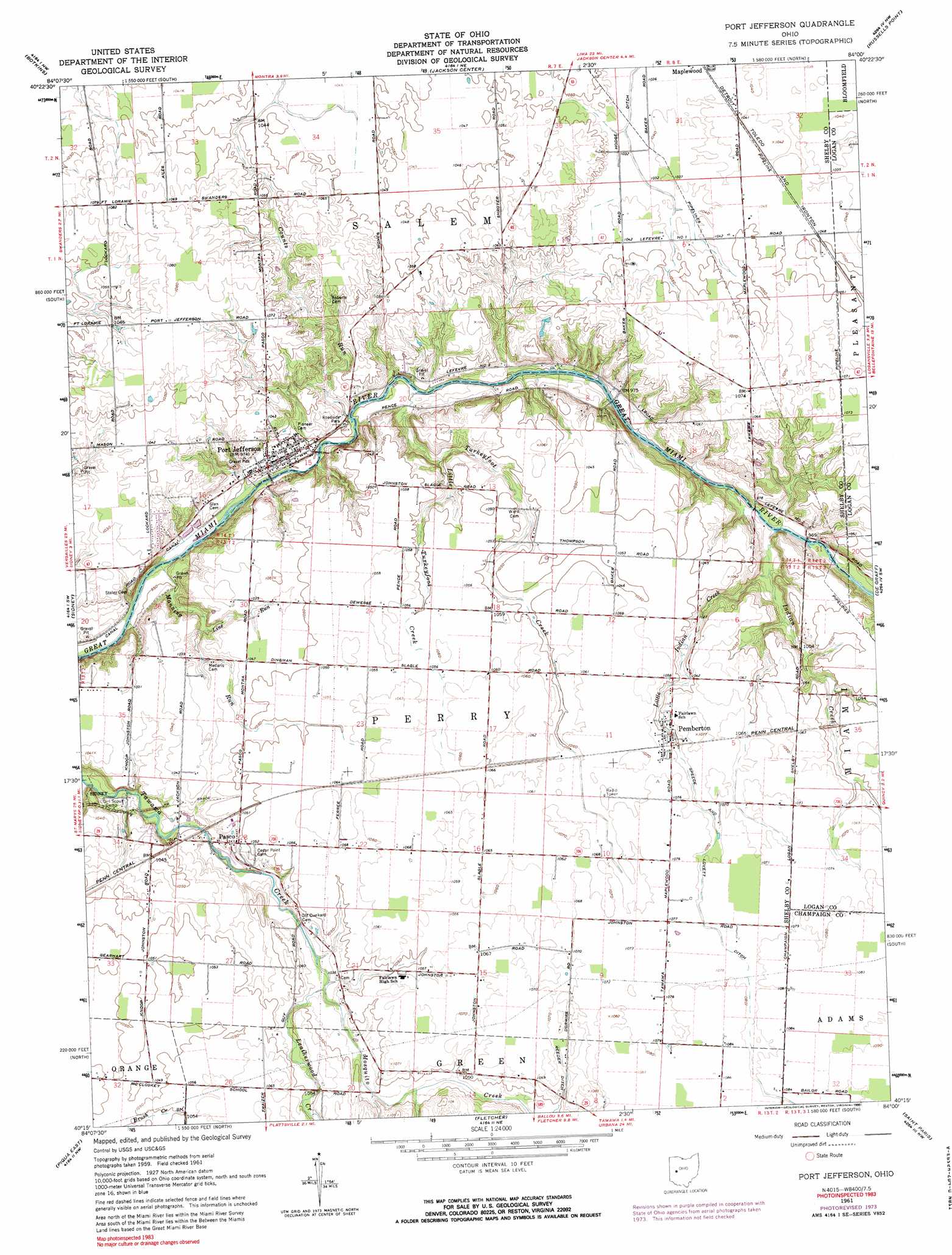
USGS Topo Quad 40084c1 - 1:24,000 scale
| Topo Map Name: | Port Jefferson |
| USGS Topo Quad ID: | 40084c1 |
| Print Size: | ca. 21 1/4" wide x 27" high |
| Southeast Coordinates: | 40.25° N latitude / 84° W longitude |
| Map Center Coordinates: | 40.3125° N latitude / 84.0625° W longitude |
| U.S. State: | OH |
| Filename: | o40084c1.jpg |
| Download Map JPG Image: | Port Jefferson topo map 1:24,000 scale |
| Map Type: | Topographic |
| Topo Series: | 7.5´ |
| Map Scale: | 1:24,000 |
| Source of Map Images: | United States Geological Survey (USGS) |
| Alternate Map Versions: |
Port Jefferson OH 1961, updated 1962 Download PDF Buy paper map Port Jefferson OH 1961, updated 1974 Download PDF Buy paper map Port Jefferson OH 1961, updated 1990 Download PDF Buy paper map Port Jefferson OH 2010 Download PDF Buy paper map Port Jefferson OH 2013 Download PDF Buy paper map Port Jefferson OH 2016 Download PDF Buy paper map |
1:24,000 Topo Quads surrounding Port Jefferson
Moulton |
Wapakoneta |
Uniopolis |
Waynesfield |
Roundhead |
New Knoxville |
Botkins |
Jackson Center |
Russells Point |
Huntsville |
Fort Loramie |
Sidney |
Port Jefferson |
De Graff |
Bellefontaine |
Piqua West |
Piqua East |
Fletcher |
Saint Paris |
Northville |
Pleasant Hill |
Troy |
Christiansburg |
Thackery |
Urbana West |
> Back to 40084a1 at 1:100,000 scale
> Back to 40084a1 at 1:250,000 scale
> Back to U.S. Topo Maps home
Port Jefferson topo map: Gazetteer
Port Jefferson: Canals
Reeder Ditch elevation 323m 1059′Port Jefferson: Populated Places
Pasco elevation 318m 1043′Pemberton elevation 321m 1053′
Port Jefferson elevation 296m 971′
Port Jefferson: Post Offices
Pasco Post Office (historical) elevation 316m 1036′Pemberton Post Office elevation 320m 1049′
Port Jefferson Post Office elevation 296m 971′
Port Jefferson: Streams
Counts Run elevation 289m 948′Indian Creek elevation 292m 958′
Leatherwood Creek elevation 311m 1020′
Line Run elevation 301m 987′
Little Indian Creek elevation 294m 964′
Little Turkeyfoot Creek elevation 299m 980′
Manning Run elevation 286m 938′
Mosquito Creek elevation 311m 1020′
Turkeyfoot Creek elevation 289m 948′
Port Jefferson digital topo map on disk
Buy this Port Jefferson topo map showing relief, roads, GPS coordinates and other geographical features, as a high-resolution digital map file on DVD:
Northern Illinois, Northern Indiana & Southwestern Michigan
Buy digital topo maps: Northern Illinois, Northern Indiana & Southwestern Michigan