New Knoxville Topo Map Ohio
To zoom in, hover over the map of New Knoxville
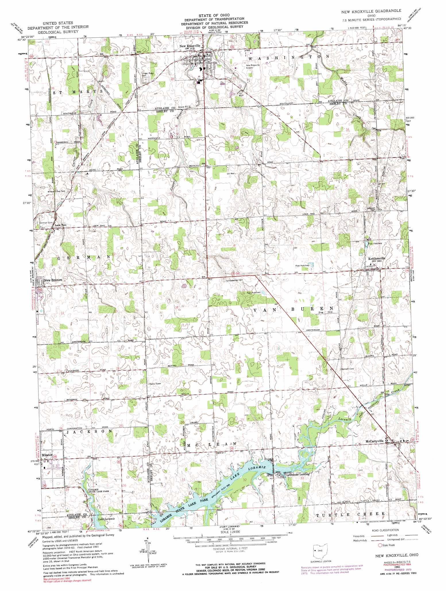
USGS Topo Quad 40084d3 - 1:24,000 scale
| Topo Map Name: | New Knoxville |
| USGS Topo Quad ID: | 40084d3 |
| Print Size: | ca. 21 1/4" wide x 27" high |
| Southeast Coordinates: | 40.375° N latitude / 84.25° W longitude |
| Map Center Coordinates: | 40.4375° N latitude / 84.3125° W longitude |
| U.S. State: | OH |
| Filename: | o40084d3.jpg |
| Download Map JPG Image: | New Knoxville topo map 1:24,000 scale |
| Map Type: | Topographic |
| Topo Series: | 7.5´ |
| Map Scale: | 1:24,000 |
| Source of Map Images: | United States Geological Survey (USGS) |
| Alternate Map Versions: |
New Knoxville OH 1961, updated 1962 Download PDF Buy paper map New Knoxville OH 1961, updated 1974 Download PDF Buy paper map New Knoxville OH 1961, updated 1991 Download PDF Buy paper map New Knoxville OH 2010 Download PDF Buy paper map New Knoxville OH 2013 Download PDF Buy paper map New Knoxville OH 2016 Download PDF Buy paper map |
1:24,000 Topo Quads surrounding New Knoxville
Mendon |
Elgin |
Spencerville |
Cridersville |
Lima |
Celina |
Saint Marys |
Moulton |
Wapakoneta |
Uniopolis |
Montezuma |
New Bremen |
New Knoxville |
Botkins |
Jackson Center |
North Star |
Osgood |
Fort Loramie |
Sidney |
Port Jefferson |
Dawn |
Versailles |
Piqua West |
Piqua East |
Fletcher |
> Back to 40084a1 at 1:100,000 scale
> Back to 40084a1 at 1:250,000 scale
> Back to U.S. Topo Maps home
New Knoxville topo map: Gazetteer
New Knoxville: Airports
Neil Armstrong Airport elevation 277m 908′New Knoxville: Parks
New Knoxville Community Park elevation 278m 912′Paris Street Park elevation 294m 964′
New Knoxville: Populated Places
Kettlersville elevation 297m 974′Lehmkuhl Landing elevation 292m 958′
Lock Two elevation 283m 928′
McCartyville elevation 297m 974′
New Knoxville elevation 275m 902′
New Knoxville: Post Offices
Kettlersville Post Office elevation 298m 977′McCartyville Post Office (historical) elevation 297m 974′
New Knoxville Post Office elevation 276m 905′
New Knoxville digital topo map on disk
Buy this New Knoxville topo map showing relief, roads, GPS coordinates and other geographical features, as a high-resolution digital map file on DVD:
Northern Illinois, Northern Indiana & Southwestern Michigan
Buy digital topo maps: Northern Illinois, Northern Indiana & Southwestern Michigan