Clatonia Topo Map Nebraska
To zoom in, hover over the map of Clatonia
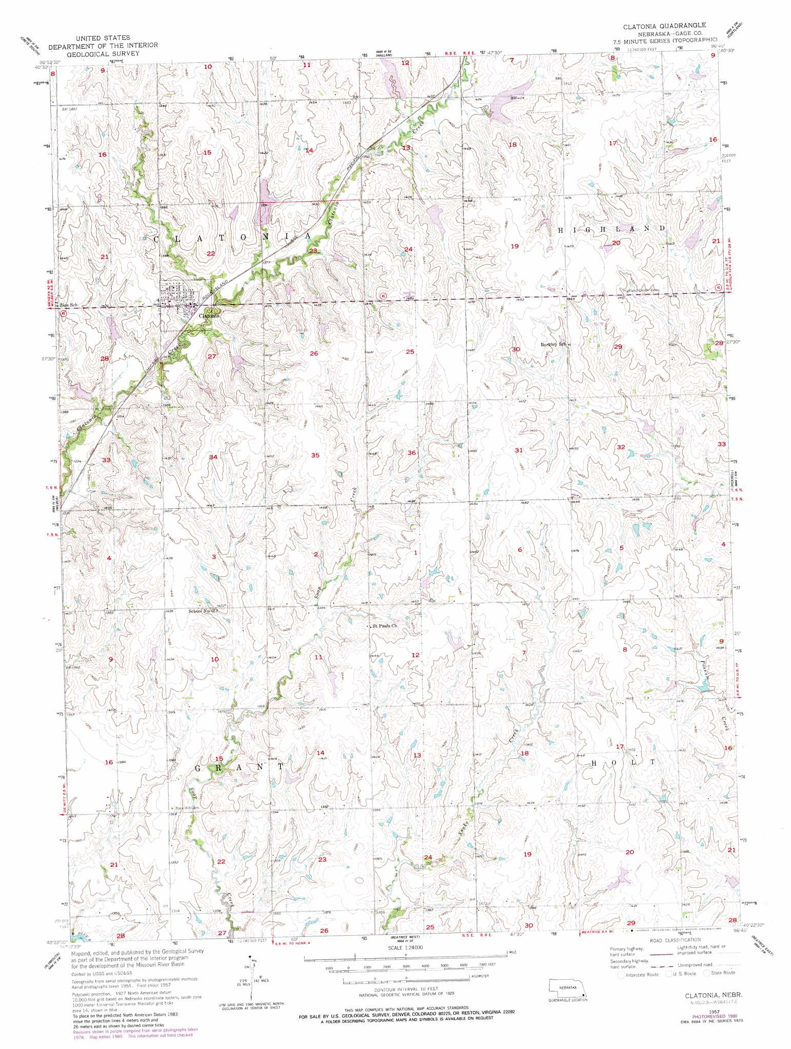
USGS Topo Quad 40096d7 - 1:24,000 scale
| Topo Map Name: | Clatonia |
| USGS Topo Quad ID: | 40096d7 |
| Print Size: | ca. 21 1/4" wide x 27" high |
| Southeast Coordinates: | 40.375° N latitude / 96.75° W longitude |
| Map Center Coordinates: | 40.4375° N latitude / 96.8125° W longitude |
| U.S. State: | NE |
| Filename: | O40096d7.jpg |
| Download Map JPG Image: | Clatonia topo map 1:24,000 scale |
| Map Type: | Topographic |
| Topo Series: | 7.5´ |
| Map Scale: | 1:24,000 |
| Source of Map Images: | United States Geological Survey (USGS) |
| Alternate Map Versions: |
Clatonia NE 1957, updated 1958 Download PDF Buy paper map Clatonia NE 1957, updated 1980 Download PDF Buy paper map Clatonia NE 2011 Download PDF Buy paper map Clatonia NE 2014 Download PDF Buy paper map |
1:24,000 Topo Quads surrounding Clatonia
Dorchester |
Crete North |
Denton |
Roca |
Bennet |
Pleasant Hill |
Crete South |
Hallam |
Cortland |
Firth |
Swanton |
Wilber |
Clatonia |
Pickrell |
Adams |
Western Se |
Plymouth |
Beatrice West |
Beatrice East |
Filley |
Jansen |
Harbine |
Odell Ne |
Blue Springs |
Wymore Ne |
> Back to 40096a1 at 1:100,000 scale
> Back to 40096a1 at 1:250,000 scale
> Back to U.S. Topo Maps home
Clatonia topo map: Gazetteer
Clatonia: Dams
Clatonia Creek Dam 2-A elevation 411m 1348′Clatonia Creek Dam 2-B elevation 419m 1374′
Clatonia Creek Dam 3-A elevation 425m 1394′
Clatonia Creek Dam 4-A elevation 414m 1358′
Clatonia Creek Dam 6-A elevation 430m 1410′
Clatonia Creek Dam 7-A elevation 427m 1400′
Clatonia Creek Dam 8-D elevation 427m 1400′
Indian Creek Dam 16-1 elevation 426m 1397′
Indian Creek Dam 16-A elevation 412m 1351′
Indian Creek Dam 2-A elevation 424m 1391′
Indian Creek Dam 3-A elevation 442m 1450′
Indian Creek Dam 3-B elevation 433m 1420′
Indian Creek Dam 3-C elevation 429m 1407′
Little Indian Creek Dam 15-A elevation 424m 1391′
Clatonia: Populated Places
Clatonia elevation 420m 1377′Clatonia: Post Offices
Clatonia Post Office elevation 420m 1377′Clatonia: Reservoirs
Clatonia Creek Reservoir 2-A elevation 411m 1348′Clatonia Creek Reservoir 2-B elevation 419m 1374′
Clatonia Creek Reservoir 3-A elevation 425m 1394′
Clatonia Creek Reservoir 4-A elevation 414m 1358′
Clatonia Creek Reservoir 6-A elevation 430m 1410′
Clatonia Creek Reservoir 7-A elevation 427m 1400′
Clatonia Creek Reservoir 8-D elevation 427m 1400′
Indian Creek Reservoir 16-1 elevation 426m 1397′
Indian Creek Reservoir 16-A elevation 412m 1351′
Indian Creek Reservoir 2-A elevation 424m 1391′
Indian Creek Reservoir 3-A elevation 442m 1450′
Indian Creek Reservoir 3-B elevation 433m 1420′
Indian Creek Reservoir 3-C elevation 429m 1407′
Little Indian Creek Reservoir 15 elevation 424m 1391′
Clatonia digital topo map on disk
Buy this Clatonia topo map showing relief, roads, GPS coordinates and other geographical features, as a high-resolution digital map file on DVD: