Allens Park Topo Map Colorado
To zoom in, hover over the map of Allens Park
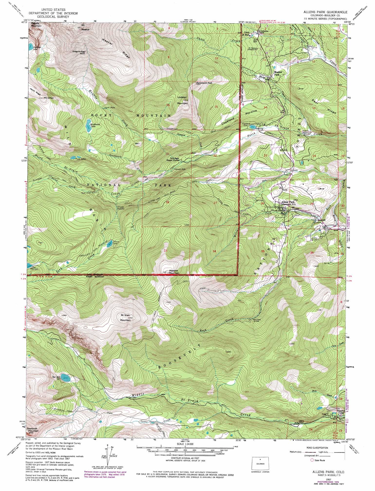
USGS Topo Quad 40105b5 - 1:24,000 scale
| Topo Map Name: | Allens Park |
| USGS Topo Quad ID: | 40105b5 |
| Print Size: | ca. 21 1/4" wide x 27" high |
| Southeast Coordinates: | 40.125° N latitude / 105.5° W longitude |
| Map Center Coordinates: | 40.1875° N latitude / 105.5625° W longitude |
| U.S. State: | CO |
| Filename: | o40105b5.jpg |
| Download Map JPG Image: | Allens Park topo map 1:24,000 scale |
| Map Type: | Topographic |
| Topo Series: | 7.5´ |
| Map Scale: | 1:24,000 |
| Source of Map Images: | United States Geological Survey (USGS) |
| Alternate Map Versions: |
Allens Park CO 1957, updated 1959 Download PDF Buy paper map Allens Park CO 1957, updated 1962 Download PDF Buy paper map Allens Park CO 1957, updated 1968 Download PDF Buy paper map Allens Park CO 1957, updated 1968 Download PDF Buy paper map Allens Park CO 1957, updated 1973 Download PDF Buy paper map Allens Park CO 1957, updated 1978 Download PDF Buy paper map Allens Park CO 1957, updated 1978 Download PDF Buy paper map Allenspark CO 2011 Download PDF Buy paper map Allenspark CO 2013 Download PDF Buy paper map Allenspark CO 2016 Download PDF Buy paper map |
| FStopo: | US Forest Service topo Allenspark is available: Download FStopo PDF Download FStopo TIF |
1:24,000 Topo Quads surrounding Allens Park
Fall River Pass |
Trail Ridge |
Estes Park |
Glen Haven |
Drake |
Grand Lake |
Mchenrys Peak |
Longs Peak |
Panorama Peak |
Pinewood Lake |
Shadow Mountain |
Isolation Peak |
Allens Park |
Raymond |
Lyons |
Strawberry Lake |
Monarch Lake |
Ward |
Gold Hill |
Boulder |
Fraser |
East Portal |
Nederland |
Tunsgten |
Eldorado Springs |
> Back to 40105a1 at 1:100,000 scale
> Back to 40104a1 at 1:250,000 scale
> Back to U.S. Topo Maps home
Allens Park topo map: Gazetteer
Allens Park: Basins
Wild Basin elevation 2966m 9730′Allens Park: Cliffs
Tent Rocks elevation 2747m 9012′Allens Park: Dams
Copeland Dam elevation 2536m 8320′Green Lake Dam elevation 3166m 10387′
Pear Dam elevation 3227m 10587′
Sand Beach Dam elevation 3136m 10288′
Allens Park: Falls
Calypso Cascades elevation 2832m 9291′Copeland Falls elevation 2598m 8523′
Lyric Falls elevation 3100m 10170′
Ouzel Falls elevation 2895m 9498′
Timberline Falls elevation 2810m 9219′
Allens Park: Lakes
Finch Lake elevation 3023m 9917′Red Deer Lake elevation 3163m 10377′
Sandbeach Lake elevation 3136m 10288′
Twin Lakes elevation 2998m 9835′
Allens Park: Mines
Twin Sister Mine elevation 2661m 8730′Allens Park: Pillars
Dragons Egg Rock elevation 3705m 12155′Allens Park: Populated Places
Allenspark elevation 2592m 8503′Arrowood elevation 2515m 8251′
Ferncliff elevation 2500m 8202′
Meeker Park elevation 2590m 8497′
Allens Park: Reservoirs
Copeland Lake elevation 2536m 8320′Green Reservoir elevation 3166m 10387′
Pear Reservoir elevation 3227m 10587′
Allens Park: Ridges
Copeland Moraine elevation 2672m 8766′Meeker Ridge elevation 3782m 12408′
Allens Park: Streams
Campers Creek elevation 2564m 8412′Coney Creek elevation 2822m 9258′
Cony Creek elevation 2741m 8992′
Fox Creek elevation 2423m 7949′
Hidden Brook elevation 2625m 8612′
Horse Creek elevation 2425m 7956′
Hunters Creek elevation 2587m 8487′
Ouzel Creek elevation 2991m 9812′
Roaring Fork elevation 2552m 8372′
Sandbeach Creek elevation 2603m 8540′
Tahosa Creek elevation 2509m 8231′
Willow Creek elevation 2482m 8143′
Allens Park: Summits
Horsetooth Peak elevation 3152m 10341′Lookout Mountain elevation 3262m 10702′
Meadow Mountain elevation 3546m 11633′
Mount Meeker elevation 4227m 13868′
Mount Orton elevation 3575m 11729′
Saint Vrain Mountain elevation 3703m 12148′
Sawtooth Mountain elevation 3739m 12267′
Allens Park: Trails
Allens Park Trail elevation 2777m 9110′Allens Park-Wild Basin Trail elevation 2945m 9662′
Beaver Creek Trail elevation 3062m 10045′
Coney Creek Trail elevation 3036m 9960′
Finch Lake-Pear Reservoir Trail elevation 3019m 9904′
Red Deer Cut-Off Trail elevation 3039m 9970′
Saint Vrain Mountain Trail elevation 3414m 11200′
Sandbeach Lake Trail elevation 2809m 9215′
Thunder Lake Trail elevation 2696m 8845′
Allens Park: Valleys
Buck Gulch elevation 2443m 8015′Tahosa Valley elevation 2538m 8326′
Allens Park digital topo map on disk
Buy this Allens Park topo map showing relief, roads, GPS coordinates and other geographical features, as a high-resolution digital map file on DVD: