Table Mountain Topo Map Colorado
To zoom in, hover over the map of Table Mountain
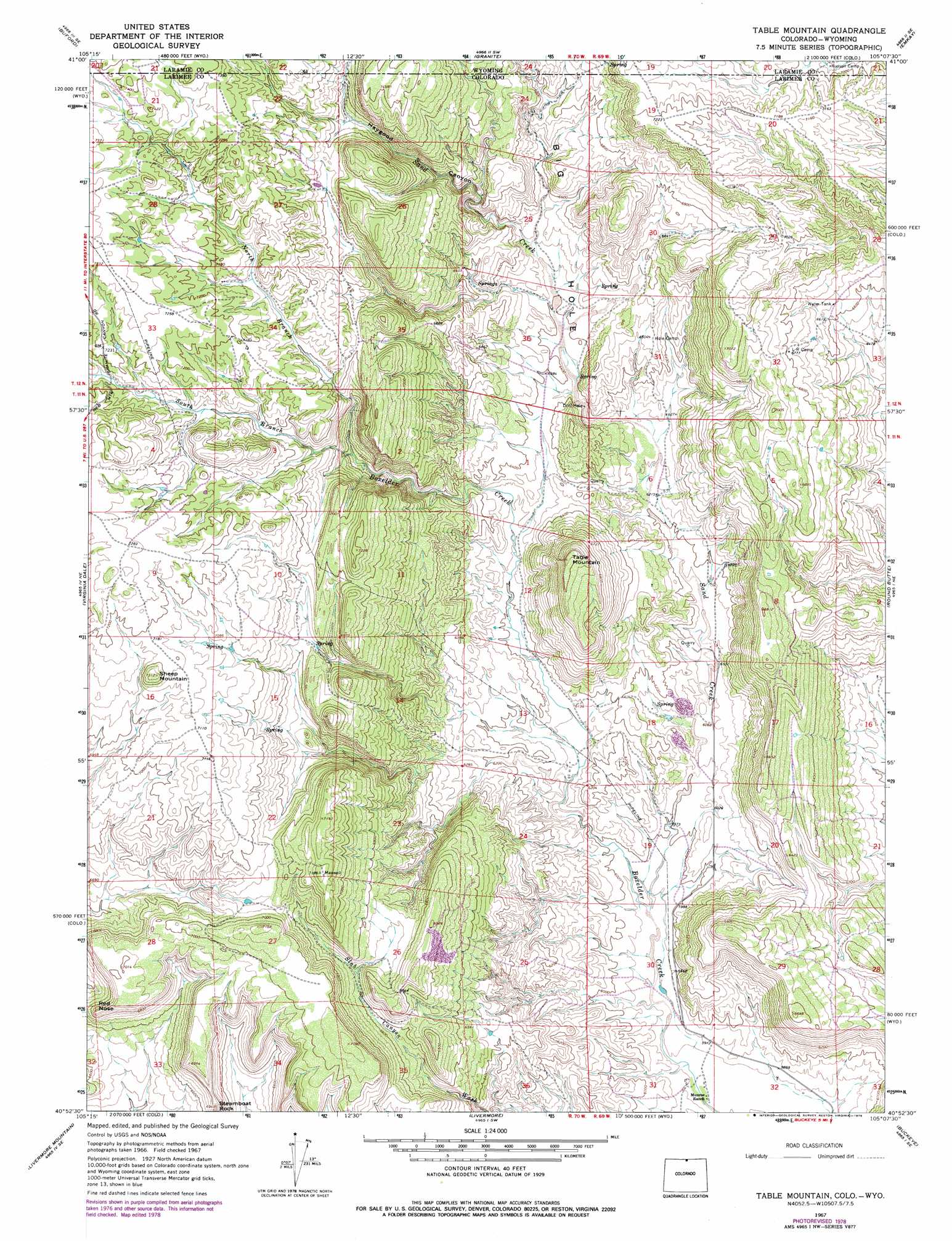
USGS Topo Quad 40105h2 - 1:24,000 scale
| Topo Map Name: | Table Mountain |
| USGS Topo Quad ID: | 40105h2 |
| Print Size: | ca. 21 1/4" wide x 27" high |
| Southeast Coordinates: | 40.875° N latitude / 105.125° W longitude |
| Map Center Coordinates: | 40.9375° N latitude / 105.1875° W longitude |
| U.S. States: | CO, WY |
| Filename: | o40105h2.jpg |
| Download Map JPG Image: | Table Mountain topo map 1:24,000 scale |
| Map Type: | Topographic |
| Topo Series: | 7.5´ |
| Map Scale: | 1:24,000 |
| Source of Map Images: | United States Geological Survey (USGS) |
| Alternate Map Versions: |
Table Mountain CO 1967, updated 1971 Download PDF Buy paper map Table Mountain CO 1967, updated 1971 Download PDF Buy paper map Table Mountain CO 1967, updated 1979 Download PDF Buy paper map Table Mountain CO 2010 Download PDF Buy paper map Table Mountain CO 2013 Download PDF Buy paper map Table Mountain CO 2016 Download PDF Buy paper map |
1:24,000 Topo Quads surrounding Table Mountain
Sherman Mountains West |
Sherman Mountains East |
Hecla |
Silver Crown |
Round Top Lake |
Dale Creek |
Buford |
Granite |
Emkay |
Borie |
Cherokee Park |
Virginia Dale |
Table Mountain |
Round Butte |
Carr West |
Haystack Gulch |
Livermore Mountain |
Livermore |
Buckeye |
Carr Sw |
Big Narrows |
Poudre Park |
Laporte |
Wellington |
Cobb Lake |
> Back to 40105e1 at 1:100,000 scale
> Back to 40104a1 at 1:250,000 scale
> Back to U.S. Topo Maps home
Table Mountain topo map: Gazetteer
Table Mountain: Cliffs
Red Nose elevation 2115m 6938′Table Mountain: Dams
Floodwater Retention B-5 Dam elevation 1885m 6184′Floodwater Retention B-6 Dam elevation 1919m 6295′
Table Mountain: Mines
Boettcher Quarry elevation 1876m 6154′Goodwin Quarry elevation 1896m 6220′
Monroe Pit elevation 1876m 6154′
Slab Canyon Quarry elevation 1883m 6177′
Table Mountain: Reservoirs
Floodwater B-6 Retention Reservoir elevation 1919m 6295′Floodwater Retention Reservoir B-5 elevation 1885m 6184′
Table Mountain: Streams
North Branch Boxelder Creek elevation 1999m 6558′Sand Creek elevation 1815m 5954′
Sand Creek elevation 1818m 5964′
South Branch Boxelder Creek elevation 1999m 6558′
Table Mountain: Summits
Sheep Mountain elevation 2224m 7296′Table Mountain elevation 2150m 7053′
Table Mountain: Valleys
Big Hole elevation 1940m 6364′Haygood Canyon elevation 2006m 6581′
Haygood Canyon elevation 2012m 6601′
Table Mountain digital topo map on disk
Buy this Table Mountain topo map showing relief, roads, GPS coordinates and other geographical features, as a high-resolution digital map file on DVD: