Putnam Topo Map Connecticut
To zoom in, hover over the map of Putnam
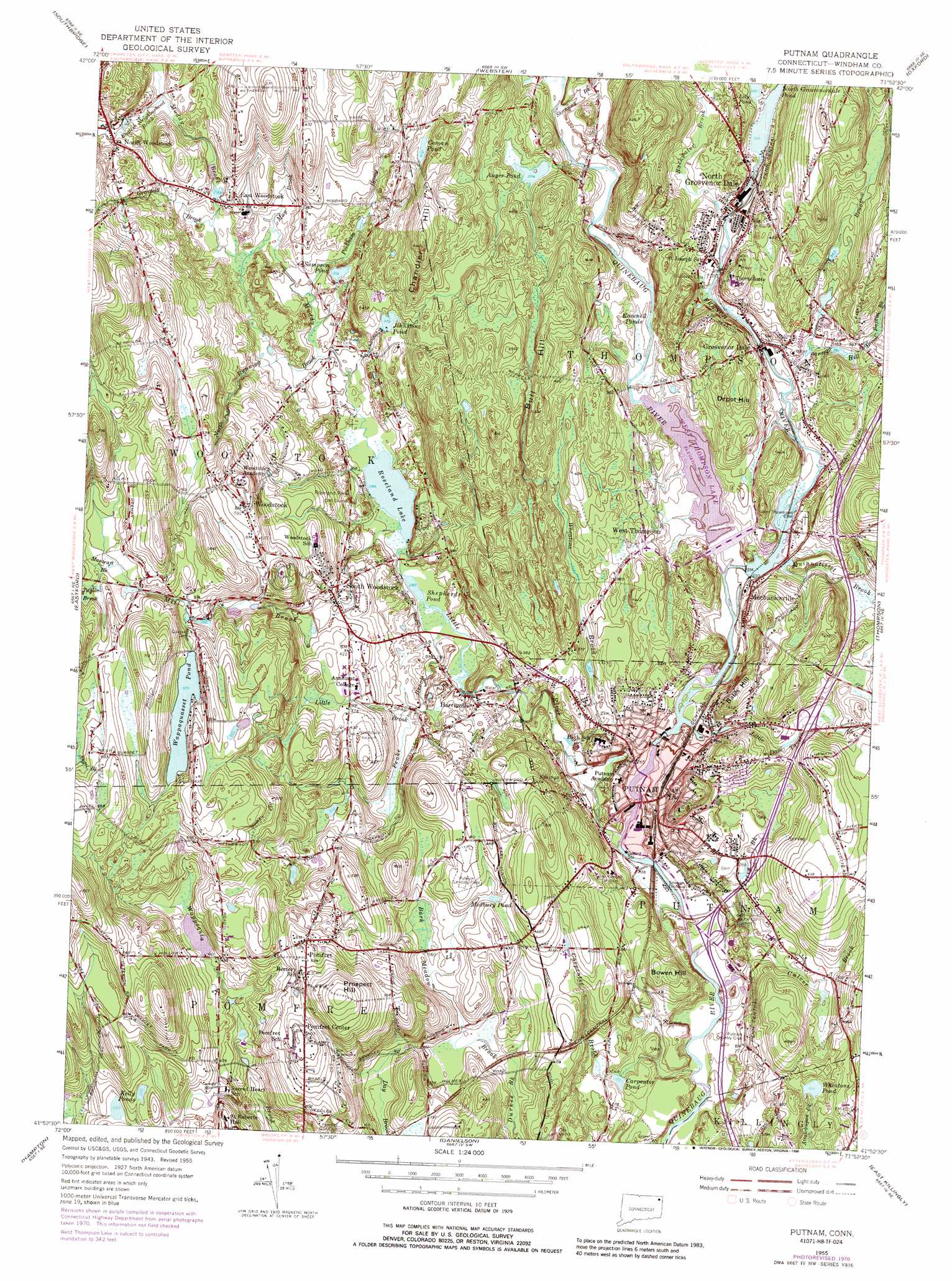
USGS Topo Quad 41071h8 - 1:24,000 scale
| Topo Map Name: | Putnam |
| USGS Topo Quad ID: | 41071h8 |
| Print Size: | ca. 21 1/4" wide x 27" high |
| Southeast Coordinates: | 41.875° N latitude / 71.875° W longitude |
| Map Center Coordinates: | 41.9375° N latitude / 71.9375° W longitude |
| U.S. State: | CT |
| Filename: | o41071h8.jpg |
| Download Map JPG Image: | Putnam topo map 1:24,000 scale |
| Map Type: | Topographic |
| Topo Series: | 7.5´ |
| Map Scale: | 1:24,000 |
| Source of Map Images: | United States Geological Survey (USGS) |
| Alternate Map Versions: |
Putnam CT 1955, updated 1958 Download PDF Buy paper map Putnam CT 1955, updated 1967 Download PDF Buy paper map Putnam CT 1955, updated 1971 Download PDF Buy paper map Putnam CT 1955, updated 1976 Download PDF Buy paper map Putnam CT 1955, updated 1988 Download PDF Buy paper map Putnam CT 2012 Download PDF Buy paper map Putnam CT 2015 Download PDF Buy paper map |
1:24,000 Topo Quads surrounding Putnam
East Brookfield |
Worcester South |
|||
Southbridge |
Oxford |
|||
Westford |
Eastford |
Putnam |
Thompson |
Chepachet |
Spring Hill |
Hampton |
Danielson |
East Killingly |
Clayville |
Willimantic |
Scotland |
Plainfield |
Oneco |
Coventry Center |
> Back to 41071e1 at 1:100,000 scale
> Back to 41070a1 at 1:250,000 scale
> Back to U.S. Topo Maps home
Putnam topo map: Gazetteer
Putnam: Airports
Woodstock Airport elevation 138m 452′Putnam: Bridges
Red Bridge elevation 100m 328′Putnam: Crossings
Interchange 95 elevation 78m 255′Interchange 96 elevation 74m 242′
Interchange 97 elevation 109m 357′
Interchange 98 elevation 122m 400′
Putnam: Dams
Acme Pond Dam elevation 101m 331′Belden Dam elevation 106m 347′
Bel-Hem Dam elevation 97m 318′
Cargill Falls Dam elevation 103m 337′
North Grosvenordale Pond Dam elevation 113m 370′
Shepherds Pond Dam elevation 88m 288′
Wappaquasset Pond Dam elevation 174m 570′
West Thompson Dam elevation 100m 328′
Putnam: Lakes
Auger Pond elevation 115m 377′Carpenter Pond elevation 81m 265′
Coman Pond elevation 136m 446′
Kelly Ponds elevation 146m 479′
Lilly Pond elevation 115m 377′
Lily Pond elevation 115m 377′
Medbury Pond elevation 132m 433′
Ravenell Ponds elevation 96m 314′
Roseland Lake elevation 87m 285′
Shepherds Pond elevation 88m 288′
Wappaquasset Pond elevation 174m 570′
Wheatons Pond elevation 96m 314′
Putnam: Parks
Murphy Recreation Park elevation 77m 252′Putnam: Populated Places
East Woodstock elevation 109m 357′Grosvenor Dale elevation 114m 374′
Harrisville elevation 94m 308′
Massomuck (historical) elevation 183m 600′
Mechanicsville elevation 104m 341′
North Grosvenor Dale elevation 111m 364′
North Woodstock elevation 122m 400′
Pomfret elevation 183m 600′
Pomfret Center elevation 190m 623′
Putnam elevation 92m 301′
Roseland Park elevation 94m 308′
South Woodstock elevation 123m 403′
West Thompson elevation 112m 367′
Woodstock elevation 184m 603′
Putnam: Post Offices
East Woodstock Post Office elevation 106m 347′Grosvenor Dale Post Office elevation 114m 374′
Pomfret Post Office elevation 179m 587′
Putnam Post Office elevation 85m 278′
South Woodstock Post Office elevation 123m 403′
Woodstock Post Office elevation 180m 590′
Putnam: Reservoirs
Acme Pond elevation 101m 331′Cargill Falls Reservoir elevation 103m 337′
John Stone Pond elevation 116m 380′
North Grosvenordale Pond elevation 113m 370′
Quinebaug River Reservoir elevation 97m 318′
Sampson Pond elevation 97m 318′
West Thompson Lake elevation 100m 328′
Putnam: Streams
Backwater Brook elevation 102m 334′Baptist Brook elevation 128m 419′
Bark Meadow Brook elevation 112m 367′
Carpenter Brook elevation 72m 236′
Culver Brook elevation 79m 259′
English Neighborhood Brook elevation 106m 347′
French River elevation 96m 314′
Gravelly Brook elevation 91m 298′
Little Brook elevation 104m 341′
Little Dam Tavern Brook elevation 97m 318′
Little River elevation 71m 232′
Mascraft Brook elevation 174m 570′
May Brook elevation 93m 305′
Mill Brook elevation 86m 282′
Muddy Brook elevation 94m 308′
North Running Brook elevation 89m 291′
Peake Brook elevation 108m 354′
Peckham Brook elevation 89m 291′
Perry Brook elevation 70m 229′
Quinnatisset Brook elevation 100m 328′
Shunway Brook elevation 98m 321′
Stoud Brook elevation 99m 324′
Sunset Hill Brook elevation 103m 337′
Taylor Brook elevation 181m 593′
Wheatons Brook elevation 73m 239′
Putnam: Summits
Bald Hill elevation 175m 574′Bartholomew Hill elevation 103m 337′
Bates Hill elevation 129m 423′
Bowen Hill elevation 114m 374′
Buck Mountain elevation 177m 580′
Bull Hill elevation 157m 515′
Chandler Hill elevation 182m 597′
Davis Hill elevation 147m 482′
Depot Hill elevation 144m 472′
Hamlet Hill elevation 226m 741′
Hospital Hill elevation 97m 318′
Peregrine White Hill elevation 134m 439′
Pomfret Hill elevation 191m 626′
Prospect Hill elevation 229m 751′
Westward Hill elevation 208m 682′
Putnam digital topo map on disk
Buy this Putnam topo map showing relief, roads, GPS coordinates and other geographical features, as a high-resolution digital map file on DVD:
Maine, New Hampshire, Rhode Island & Eastern Massachusetts
Buy digital topo maps: Maine, New Hampshire, Rhode Island & Eastern Massachusetts