Southbridge Topo Map Massachusetts
To zoom in, hover over the map of Southbridge
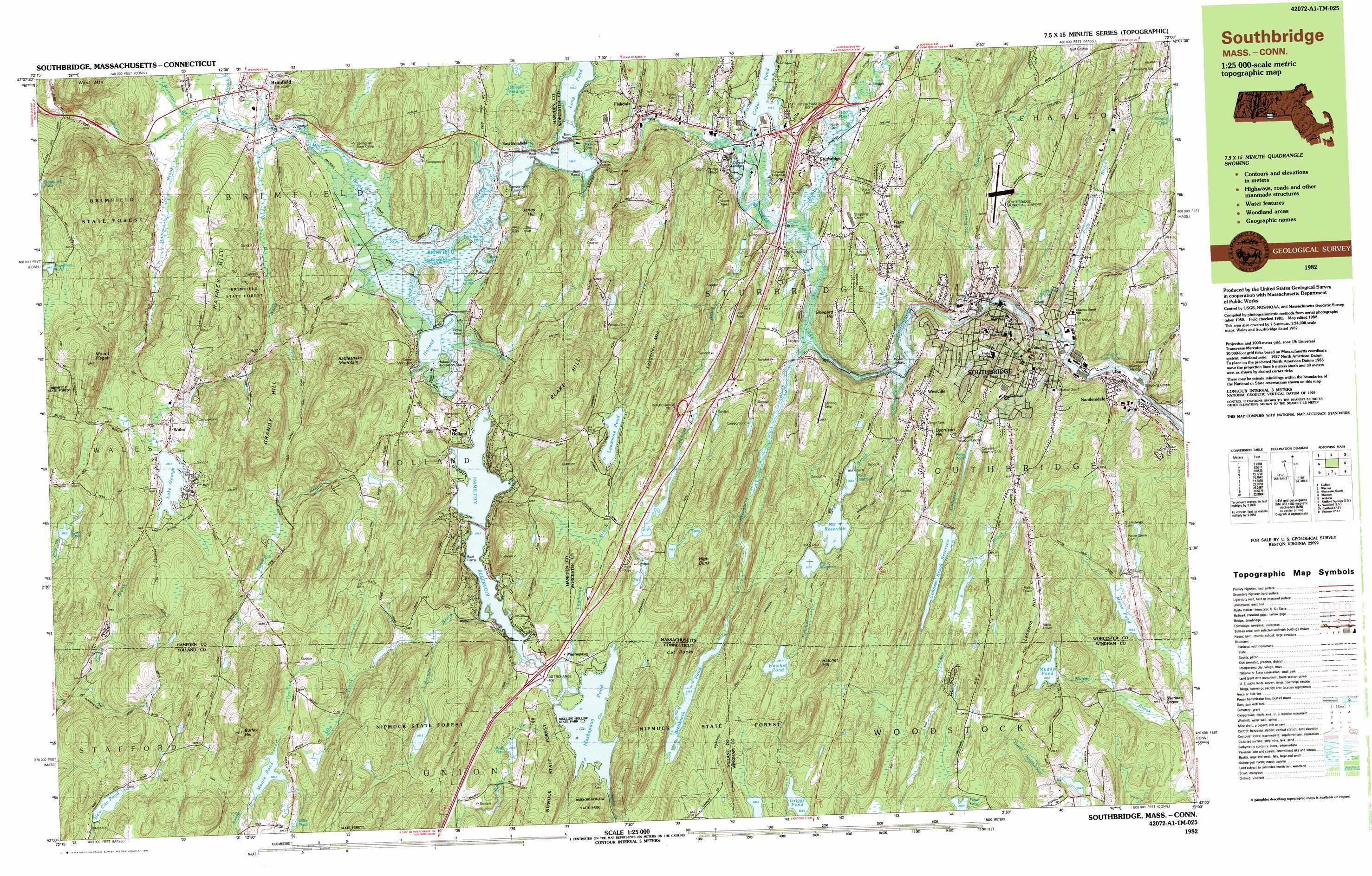
USGS Topo Quad 42072a1 - 1:25,000 scale
| Topo Map Name: | Southbridge |
| USGS Topo Quad ID: | 42072a1 |
| Print Size: | ca. 39" wide x 24" high |
| Southeast Coordinates: | 42° N latitude / 72° W longitude |
| Map Center Coordinates: | 42.0625° N latitude / 72.125° W longitude |
| U.S. States: | MA, CT |
| Filename: | k42072a1.jpg |
| Download Map JPG Image: | Southbridge topo map 1:25,000 scale |
| Map Type: | Topographic |
| Topo Series: | 7.5´x15´ |
| Map Scale: | 1:25,000 |
| Source of Map Images: | United States Geological Survey (USGS) |
| Alternate Map Versions: |
Southbridge MA 1982, updated 1983 Download PDF Buy paper map Southbridge MA 1982, updated 1983 Download PDF Buy paper map |
1:24,000 Topo Quads surrounding Southbridge
Winsor Dam |
North Brookfield |
Worcester North |
||
Palmer |
East Brookfield |
Worcester South |
||
Monson |
Southbridge |
Oxford |
||
Stafford Springs |
Westford |
Eastford |
Putnam |
Thompson |
South Coventry |
Spring Hill |
Hampton |
Danielson |
East Killingly |
> Back to 42072a1 at 1:100,000 scale
> Back to 42072a1 at 1:250,000 scale
> Back to U.S. Topo Maps home
Southbridge topo map: Gazetteer
Southbridge: Airports
Southbridge Municipal Airport elevation 209m 685′Southbridge: Beaches
Woodstock Town Beach elevation 201m 659′Southbridge: Dams
Cedar Pond Dam elevation 174m 570′Cohasse Country Club Dam elevation 169m 554′
Cohasse Reservoir Dam elevation 193m 633′
Diversion Dam elevation 127m 416′
East Brimfield Dam elevation 194m 636′
Goodhall Dam elevation 212m 695′
Hamilton Reservoir Dam elevation 208m 682′
Hatchet Pond Dam elevation 263m 862′
Lake George Dam elevation 280m 918′
Lensdale Pond Dam elevation 132m 433′
Mashapaug Pond Dam elevation 215m 705′
Mashapaug Pond Dike elevation 212m 695′
Mashapaug Pond Spillway Dam elevation 217m 711′
Moore Pond Dam elevation 285m 935′
New City Pond Dam elevation 271m 889′
Number Five Reservoir Dam elevation 226m 741′
Number Four Reservoir Dam elevation 215m 705′
Prindle Lake Dam elevation 213m 698′
Reservoir Number Three Dam elevation 206m 675′
Russell Harrington Mill Pond Dam elevation 147m 482′
Sessions Meadow Marsh Dam elevation 267m 875′
Sturbridge Village Pond Dam elevation 174m 570′
Vinica Pond Dam elevation 295m 967′
Wallace Pond Dam (historical) elevation 219m 718′
Wells Pond Dam elevation 239m 784′
Westville Dam elevation 174m 570′
Wheeler Pond Dam elevation 200m 656′
Woodman Pond Dam elevation 297m 974′
Southbridge: Forests
Brimfield State Forest elevation 301m 987′Nipmuck State Forest elevation 288m 944′
Southbridge: Lakes
Breakneck Pond elevation 207m 679′Carpenter Pond elevation 134m 439′
Cedar Pond elevation 174m 570′
Green Pond elevation 195m 639′
Hatchet Pond elevation 263m 862′
Holland Pond elevation 193m 633′
Leadmine Pond elevation 249m 816′
Lost Lake elevation 193m 633′
Moore Pond elevation 285m 935′
Morse Pond elevation 158m 518′
Muddy Pond elevation 200m 656′
Pork Barrel Pond elevation 193m 633′
Potter Pond elevation 206m 675′
Wells Pond elevation 239m 784′
Willis Pond elevation 304m 997′
Southbridge: Parks
Bacon-Morse Historic District elevation 163m 534′Bigelow Hollow State Park elevation 226m 741′
Central Mills Historic District elevation 131m 429′
Glover Street Historic District elevation 181m 593′
High School Street Historic District elevation 170m 557′
Solair Recreation League elevation 243m 797′
Sturbridge Common Historic District elevation 188m 616′
Upper Chapin Street Historic District elevation 164m 538′
Windsor Court Historic District elevation 132m 433′
Southbridge: Populated Places
Brimfield elevation 202m 662′East Brimfield elevation 200m 656′
Fiskdale elevation 191m 626′
Globe Village elevation 155m 508′
Holland elevation 212m 695′
Mashapaug elevation 213m 698′
Old Sturbridge Village elevation 181m 593′
Robinson Crusoe Camp elevation 185m 606′
Sandersdale elevation 122m 400′
Snellville (historical) elevation 183m 600′
Southbridge elevation 150m 492′
Sturbridge elevation 179m 587′
Wales elevation 284m 931′
Westville elevation 174m 570′
Southbridge: Post Offices
Brimfield Post Office elevation 202m 662′Southbridge Post Office elevation 146m 479′
Sturbridge Post Office elevation 181m 593′
Southbridge: Reservoirs
Cohasse Brook Reservoir elevation 191m 626′East Brimfield Lake elevation 195m 639′
Goodhall Pond elevation 212m 695′
Hamant Brook Reservoir elevation 219m 718′
Hamilton Reservoir elevation 209m 685′
Hamilton Reservoir elevation 209m 685′
Lake George elevation 280m 918′
Lensdale Pond elevation 132m 433′
Mashapaug Pond elevation 217m 711′
New City Pond elevation 271m 889′
Number Five Reservoir elevation 226m 741′
Number Four Reservoir elevation 215m 705′
Number One Reservoir elevation 182m 597′
Number Three Reservoir elevation 206m 675′
Number Two Reservoir elevation 200m 656′
Pistol Pond elevation 174m 570′
Prindle Lake elevation 213m 698′
Sessions Meadow Marsh elevation 267m 875′
Vinica Pond elevation 295m 967′
Wells Pond elevation 175m 574′
Westville Lake elevation 173m 567′
Wheeler Pond elevation 200m 656′
Woodman Pond elevation 298m 977′
Southbridge: Ridges
Grandy Hill elevation 327m 1072′Southbridge: Streams
Breakneck Brook elevation 174m 570′Browns Brook elevation 209m 685′
Browns Brook elevation 208m 682′
Cady Brook elevation 127m 416′
Cedar Brook elevation 174m 570′
Charles Brook elevation 202m 662′
Cohasse Brook elevation 129m 423′
East Brook elevation 198m 649′
Hamant Brook elevation 174m 570′
Hatchet Brook elevation 174m 570′
Hobbs Brook elevation 174m 570′
Hollow Brook elevation 202m 662′
Honey Brook elevation 174m 570′
Leadmine Brook elevation 212m 695′
Lebanon Brook elevation 127m 416′
Lebanon Brook elevation 126m 413′
Lombards Brook elevation 201m 659′
May Brook elevation 232m 761′
May Brook elevation 232m 761′
McKinstry Brook elevation 152m 498′
Mill Brook elevation 194m 636′
Mountain Brook elevation 202m 662′
Potter Pond Brook elevation 190m 623′
Stevens Brook elevation 208m 682′
Wales Brook elevation 200m 656′
Wells Brook elevation 215m 705′
West Brook elevation 200m 656′
Southbridge: Summits
Blake Hill elevation 328m 1076′Burley Hill elevation 396m 1299′
Cat Rocks elevation 235m 770′
Dennison Hill elevation 239m 784′
Fiske Hill elevation 261m 856′
Gage Hill elevation 245m 803′
Griggs Hill elevation 223m 731′
Hatchet Hill elevation 313m 1026′
Haynes Hill elevation 269m 882′
High Bunk elevation 274m 898′
Janes Hill elevation 263m 862′
Leadmine Mountain elevation 287m 941′
Lebanon Hill elevation 252m 826′
Mount Pisgah elevation 379m 1243′
Rattlesnake Mountain elevation 335m 1099′
Shepard Hill elevation 241m 790′
Southbridge: Swamps
Dark Swamp elevation 204m 669′Single Swamp elevation 222m 728′
Southbridge digital topo map on disk
Buy this Southbridge topo map showing relief, roads, GPS coordinates and other geographical features, as a high-resolution digital map file on DVD:
New York, Vermont, Connecticut & Western Massachusetts
Buy digital topo maps: New York, Vermont, Connecticut & Western Massachusetts