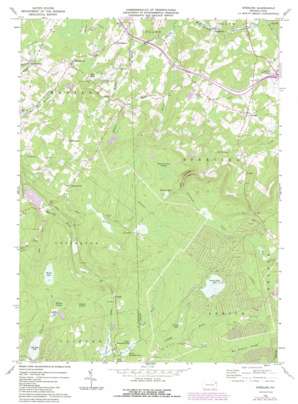
Sterling Topo Map Pennsylvania
To zoom in, hover over the map of Sterling
USGS Topo Quad 41075c4 - 1:24,000 scale
| Topo Map Name: | Sterling |
| USGS Topo Quad ID: | 41075c4 |
| Print Size: | ca. 21 1/4" wide x 27" high |
| Southeast Coordinates: | 41.25° N latitude / 75.375° W longitude |
| Map Center Coordinates: | 41.3125° N latitude / 75.4375° W longitude |
| U.S. State: | PA |
| Filename: | o41075c4.jpg |
| Download Map JPG Image: | Sterling topo map 1:24,000 scale |
| Map Type: | Topographic |
| Topo Series: | 7.5´ |
| Map Scale: | 1:24,000 |
| Source of Map Images: | United States Geological Survey (USGS) |
| Alternate Map Versions: |
Sterling PA 1965, updated 1967 Download PDF Buy paper map Sterling PA 1965, updated 1974 Download PDF Buy paper map Sterling PA 1965, updated 1984 Download PDF Buy paper map Sterling PA 1994, updated 1995 Download PDF Buy paper map Sterling PA 1997, updated 2000 Download PDF Buy paper map Sterling PA 2010 Download PDF Buy paper map Sterling PA 2013 Download PDF Buy paper map Sterling PA 2016 Download PDF Buy paper map |
1:24,000 Topo Quads surrounding Sterling
> Back to 41075a1 at 1:100,000 scale
> Back to 41074a1 at 1:250,000 scale
> Back to U.S. Topo Maps home
Sterling topo map: Gazetteer
Sterling: Airports
Air Haven Airport elevation 511m 1676′Spring Hill Airpark elevation 514m 1686′
Sterling: Dams
Big Bass Lake Dam elevation 562m 1843′Crystal Lake Dam elevation 617m 2024′
Hollister Dam elevation 503m 1650′
Kopicki Dam elevation 547m 1794′
Lake Henry Dam elevation 574m 1883′
Larsen Dam elevation 570m 1870′
Lower Dam elevation 586m 1922′
Lower Klondike Dam elevation 575m 1886′
Robinson Dam elevation 463m 1519′
Tamarack Dam elevation 560m 1837′
Sterling: Lakes
Larsen Lake elevation 570m 1870′Lehigh Pond elevation 598m 1961′
Upper Wilcox Pond elevation 551m 1807′
Sterling: Populated Places
Aberdeen elevation 486m 1594′Bloomington elevation 561m 1840′
Callapoose elevation 398m 1305′
Freytown elevation 590m 1935′
Jericho elevation 481m 1578′
Jubilee elevation 525m 1722′
Lehigh elevation 576m 1889′
Madisonville elevation 523m 1715′
Pocono Springs elevation 630m 2066′
Quicktown elevation 470m 1541′
Sterling elevation 492m 1614′
Turnersville elevation 555m 1820′
Sterling: Reservoirs
Big Bass Lake elevation 562m 1843′Crystal Lake elevation 617m 2024′
Haas Pond elevation 481m 1578′
Henry Lake elevation 579m 1899′
Hollister Reservoir elevation 503m 1650′
Lake Henry elevation 574m 1883′
Lower Klondike Pond elevation 576m 1889′
Memory Lake elevation 578m 1896′
Pocono Peak Lake elevation 623m 2043′
Robinson Lake elevation 463m 1519′
Snag Pond elevation 572m 1876′
Upper Klondike Pond elevation 579m 1899′
Sterling: Streams
East Branch Roaring Brook elevation 504m 1653′Emerson Run elevation 523m 1715′
Lake Run elevation 504m 1653′
Potter Creek elevation 432m 1417′
Stevens Creek elevation 393m 1289′
Webster Creek elevation 454m 1489′
West Fork Lehigh River elevation 584m 1916′
Sterling: Swamps
Big Sampson Swamp elevation 646m 2119′English Swamp elevation 595m 1952′
Thousand Acre Swamp elevation 589m 1932′
Wildcat Swamp elevation 577m 1893′
Sterling: Valleys
Gas Hollow elevation 498m 1633′Sterling digital topo map on disk
Buy this Sterling topo map showing relief, roads, GPS coordinates and other geographical features, as a high-resolution digital map file on DVD:
New York, Vermont, Connecticut & Western Massachusetts
Buy digital topo maps: New York, Vermont, Connecticut & Western Massachusetts


