Meshoppen Topo Map Pennsylvania
To zoom in, hover over the map of Meshoppen
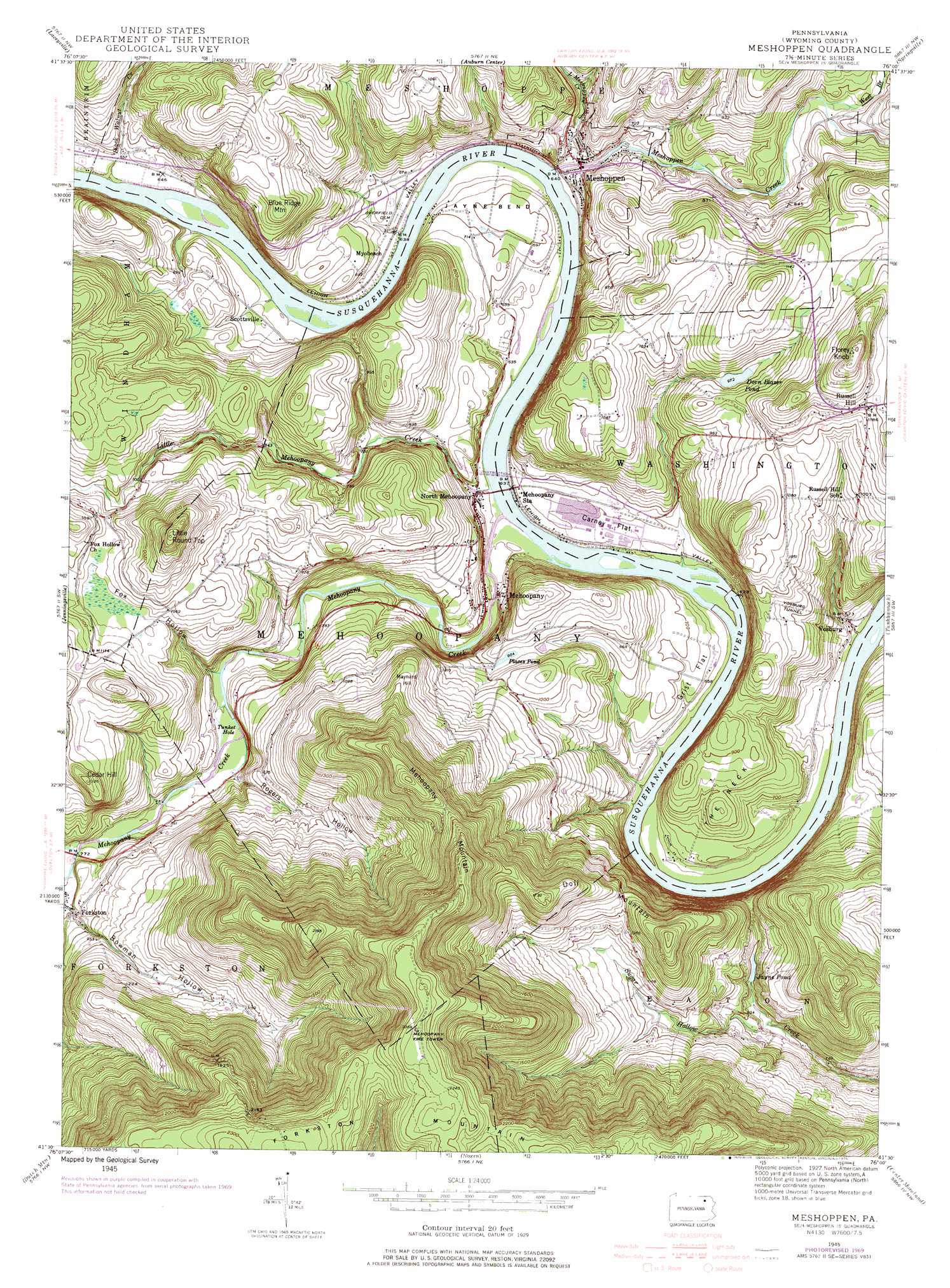
USGS Topo Quad 41076e1 - 1:24,000 scale
| Topo Map Name: | Meshoppen |
| USGS Topo Quad ID: | 41076e1 |
| Print Size: | ca. 21 1/4" wide x 27" high |
| Southeast Coordinates: | 41.5° N latitude / 76° W longitude |
| Map Center Coordinates: | 41.5625° N latitude / 76.0625° W longitude |
| U.S. State: | PA |
| Filename: | o41076e1.jpg |
| Download Map JPG Image: | Meshoppen topo map 1:24,000 scale |
| Map Type: | Topographic |
| Topo Series: | 7.5´ |
| Map Scale: | 1:24,000 |
| Source of Map Images: | United States Geological Survey (USGS) |
| Alternate Map Versions: |
Meshoppen PA 1945, updated 1956 Download PDF Buy paper map Meshoppen PA 1945, updated 1969 Download PDF Buy paper map Meshoppen PA 1945, updated 1971 Download PDF Buy paper map Meshoppen PA 1945, updated 1976 Download PDF Buy paper map Meshoppen PA 1999, updated 2001 Download PDF Buy paper map Meshoppen PA 2010 Download PDF Buy paper map Meshoppen PA 2013 Download PDF Buy paper map Meshoppen PA 2016 Download PDF Buy paper map |
1:24,000 Topo Quads surrounding Meshoppen
Rome |
Le Raysville |
Lawton |
Montrose West |
Montrose East |
Wyalusing |
Laceyville |
Auburn Center |
Springville |
Hop Bottom |
Colley |
Jenningsville |
Meshoppen |
Tunkhannock |
Factoryville |
Lopez |
Dutch Mountain |
Noxen |
Center Moreland |
Ransom |
Red Rock |
Sweet Valley |
Harveys Lake |
Kingston |
Pittston |
> Back to 41076e1 at 1:100,000 scale
> Back to 41076a1 at 1:250,000 scale
> Back to U.S. Topo Maps home
Meshoppen topo map: Gazetteer
Meshoppen: Airports
Chambers Airport elevation 279m 915′Meshoppen: Bends
Jayne Bend elevation 220m 721′Tunket Hole elevation 219m 718′
Meshoppen: Capes
The Neck elevation 275m 902′Meshoppen: Flats
Carney Flat elevation 201m 659′Grist Flat elevation 206m 675′
Meshoppen: Lakes
Dorn Blazer Pond elevation 297m 974′Jayne Pond elevation 267m 875′
Places Pond elevation 276m 905′
Meshoppen: Populated Places
Mehoopany elevation 199m 652′Meshoppen elevation 200m 656′
Myobeach elevation 227m 744′
North Mehoopany elevation 192m 629′
Scottsville elevation 202m 662′
Vosburg elevation 190m 623′
Meshoppen: Ranges
Endless Mountains elevation 189m 620′Meshoppen: Streams
Black Walnut Creek elevation 190m 623′Little Mehoopany Creek elevation 186m 610′
Little Meshoppen Creek elevation 191m 626′
Mehoopany Creek elevation 184m 603′
Meshoppen Creek elevation 188m 616′
North Branch Mehoopany Creek elevation 231m 757′
West Branch Meshoppen Creek elevation 228m 748′
Meshoppen: Summits
Blue Ridge Mountain elevation 358m 1174′Cedar Hill elevation 399m 1309′
Doll Mountain elevation 520m 1706′
Florey Knob elevation 461m 1512′
Forkston Mountain elevation 715m 2345′
Little Round Top elevation 469m 1538′
Maynard Hill elevation 399m 1309′
Mehoopany Mountain elevation 578m 1896′
Russell Hill elevation 409m 1341′
Meshoppen: Tunnels
Vosburg Tunnel elevation 283m 928′Meshoppen: Valleys
Bowman Hollow elevation 253m 830′Fox Hollow elevation 216m 708′
Rogers Hollow elevation 229m 751′
Meshoppen digital topo map on disk
Buy this Meshoppen topo map showing relief, roads, GPS coordinates and other geographical features, as a high-resolution digital map file on DVD:
New York, Vermont, Connecticut & Western Massachusetts
Buy digital topo maps: New York, Vermont, Connecticut & Western Massachusetts