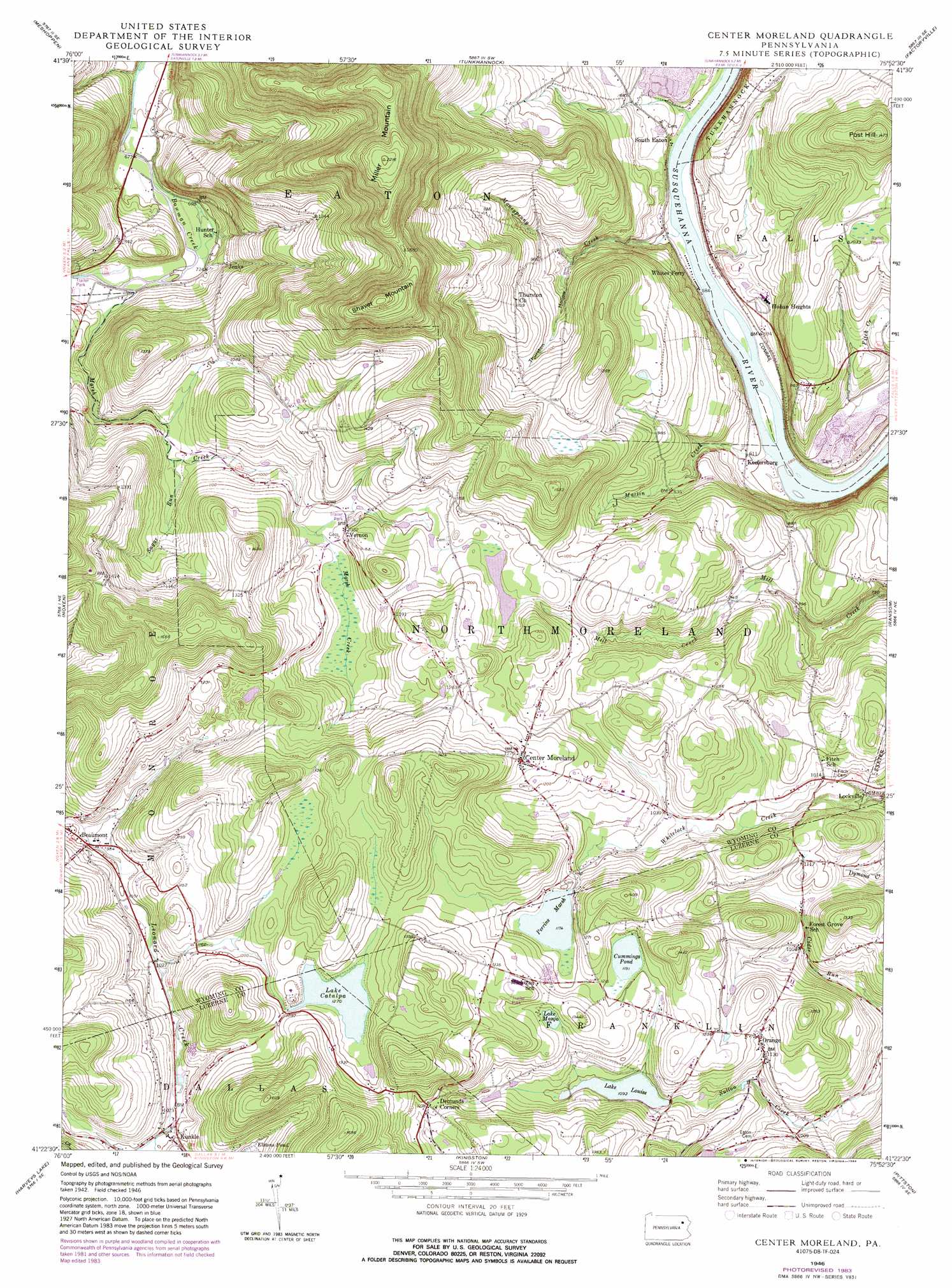
Center Moreland Topo Map Pennsylvania
To zoom in, hover over the map of Center Moreland
USGS Topo Quad 41075d8 - 1:24,000 scale
| Topo Map Name: | Center Moreland |
| USGS Topo Quad ID: | 41075d8 |
| Print Size: | ca. 21 1/4" wide x 27" high |
| Southeast Coordinates: | 41.375° N latitude / 75.875° W longitude |
| Map Center Coordinates: | 41.4375° N latitude / 75.9375° W longitude |
| U.S. State: | PA |
| Filename: | o41075d8.jpg |
| Download Map JPG Image: | Center Moreland topo map 1:24,000 scale |
| Map Type: | Topographic |
| Topo Series: | 7.5´ |
| Map Scale: | 1:24,000 |
| Source of Map Images: | United States Geological Survey (USGS) |
| Alternate Map Versions: |
Center Moreland PA 1946, updated 1969 Download PDF Buy paper map Center Moreland PA 1946, updated 1978 Download PDF Buy paper map Center Moreland PA 1946, updated 1984 Download PDF Buy paper map Center Moreland PA 1949 Download PDF Buy paper map Center Moreland PA 1949, updated 1949 Download PDF Buy paper map Center Moreland PA 2010 Download PDF Buy paper map Center Moreland PA 2013 Download PDF Buy paper map Center Moreland PA 2016 Download PDF Buy paper map |
1:24,000 Topo Quads surrounding Center Moreland
Laceyville |
Auburn Center |
Springville |
Hop Bottom |
Lenoxville |
Jenningsville |
Meshoppen |
Tunkhannock |
Factoryville |
Dalton |
Dutch Mountain |
Noxen |
Center Moreland |
Ransom |
Scranton |
Sweet Valley |
Harveys Lake |
Kingston |
Pittston |
Avoca |
Shickshinny |
Nanticoke |
Wilkes-Barre West |
Wilkes-Barre East |
Pleasant View Summit |
> Back to 41075a1 at 1:100,000 scale
> Back to 41074a1 at 1:250,000 scale
> Back to U.S. Topo Maps home
Center Moreland topo map: Gazetteer
Center Moreland: Dams
Hirsh Dam elevation 600m 1968′Lake Catalpa Dam elevation 357m 1171′
Lake Louise Dam elevation 330m 1082′
Lake Manjo Dam elevation 378m 1240′
Perrins Marsh Dam elevation 354m 1161′
Center Moreland: Populated Places
Beaumont elevation 303m 994′Center Moreland elevation 383m 1256′
Demunds Corners elevation 388m 1272′
Hoban Heights elevation 186m 610′
Jenks elevation 240m 787′
Keelersburg elevation 185m 606′
Kunkle elevation 326m 1069′
Lockville elevation 276m 905′
Mill City (historical) elevation 357m 1171′
Orange elevation 351m 1151′
South Eaton elevation 185m 606′
Vernon elevation 329m 1079′
Center Moreland: Reservoirs
Cummings Pond elevation 366m 1200′Hirsh Pond elevation 600m 1968′
Lake Catalpa elevation 385m 1263′
Lake Louise elevation 330m 1082′
Lake Manjo elevation 373m 1223′
Perrins Marsh elevation 356m 1167′
Center Moreland: Streams
Marsh Creek elevation 219m 718′Martin Creek elevation 171m 561′
Moneypenny Creek elevation 173m 567′
Sugar Run elevation 285m 935′
Center Moreland: Summits
Miller Mountain elevation 672m 2204′Post Hill elevation 449m 1473′
Shaver Mountain elevation 657m 2155′
Center Moreland: Valleys
Thurston Hollow elevation 259m 849′Center Moreland digital topo map on disk
Buy this Center Moreland topo map showing relief, roads, GPS coordinates and other geographical features, as a high-resolution digital map file on DVD:
New York, Vermont, Connecticut & Western Massachusetts
Buy digital topo maps: New York, Vermont, Connecticut & Western Massachusetts