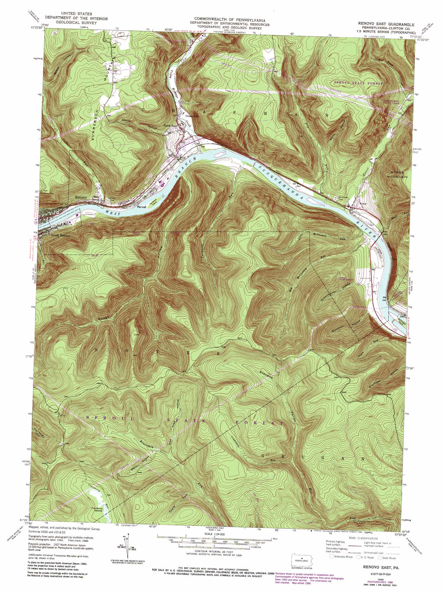
Renovo East Topo Map Pennsylvania
To zoom in, hover over the map of Renovo East
USGS Topo Quad 41077c6 - 1:24,000 scale
| Topo Map Name: | Renovo East |
| USGS Topo Quad ID: | 41077c6 |
| Print Size: | ca. 21 1/4" wide x 27" high |
| Southeast Coordinates: | 41.25° N latitude / 77.625° W longitude |
| Map Center Coordinates: | 41.3125° N latitude / 77.6875° W longitude |
| U.S. State: | PA |
| Filename: | o41077c6.jpg |
| Download Map JPG Image: | Renovo East topo map 1:24,000 scale |
| Map Type: | Topographic |
| Topo Series: | 7.5´ |
| Map Scale: | 1:24,000 |
| Source of Map Images: | United States Geological Survey (USGS) |
| Alternate Map Versions: |
Renovo East PA 1946, updated 1958 Download PDF Buy paper map Renovo East PA 1946, updated 1972 Download PDF Buy paper map Renovo East PA 1946, updated 1980 Download PDF Buy paper map Renovo East PA 1946, updated 1986 Download PDF Buy paper map Renovo East PA 1948 Download PDF Buy paper map Renovo East PA 2010 Download PDF Buy paper map Renovo East PA 2013 Download PDF Buy paper map Renovo East PA 2016 Download PDF Buy paper map |
1:24,000 Topo Quads surrounding Renovo East
Conrad |
Short Run |
Oleona |
Lee Fire Tower |
Cedar Run |
Hammersley Fork |
Tamarack |
Young Womans Creek |
Slate Run |
Cammal |
Keating |
Renovo West |
Renovo East |
Glen Union |
Jersey Mills |
Snow Shoe Nw |
Snow Shoe Ne |
Howard Nw |
Farrandsville |
Lock Haven |
Snow Shoe |
Snow Shoe Se |
Howard |
Beech Creek |
Mill Hall |
> Back to 41077a1 at 1:100,000 scale
> Back to 41076a1 at 1:250,000 scale
> Back to U.S. Topo Maps home
Renovo East topo map: Gazetteer
Renovo East: Airports
Hyner Landing Field elevation 198m 649′Renovo East: Areas
Cranberry Swamp Natural Area elevation 544m 1784′Renovo East: Islands
McCloskey Island elevation 186m 610′Tamarack Island elevation 192m 629′
Renovo East: Parks
Hyner Run State Park elevation 308m 1010′Renovo East: Populated Places
Farwell elevation 207m 679′Gleasonton elevation 203m 666′
Hyner elevation 198m 649′
North Bend elevation 204m 669′
South Renovo elevation 213m 698′
Renovo East: Streams
Big McCloskey Run elevation 185m 606′Caldwell Run elevation 189m 620′
Crabapple Run elevation 422m 1384′
Dry Run elevation 187m 613′
Green Run elevation 186m 610′
Huff Run elevation 189m 620′
Hyner Run elevation 188m 616′
Left Branch Young Womans Creek elevation 216m 708′
Little McCloskey Run elevation 185m 606′
Paddy Run elevation 194m 636′
Taylor Fork elevation 438m 1437′
Young Womans Creek elevation 190m 623′
Renovo East: Swamps
Cranberry Swamp elevation 544m 1784′Renovo East: Trails
Caldwell Run Trail elevation 368m 1207′Chuck Keiper Trail elevation 454m 1489′
Green Run Trail elevation 461m 1512′
Little McCloskey Trail elevation 583m 1912′
Renovo East: Valleys
Boggs Hollow elevation 200m 656′Log Road Hollow elevation 247m 810′
Schoolhouse Hollow elevation 194m 636′
Skunk Hollow elevation 231m 757′
Sled Road Hollow elevation 454m 1489′
Stevens Valley elevation 422m 1384′
Stone Hollow elevation 244m 800′
Weaver Hollow elevation 269m 882′
Wertz Hollow elevation 463m 1519′
Renovo East digital topo map on disk
Buy this Renovo East topo map showing relief, roads, GPS coordinates and other geographical features, as a high-resolution digital map file on DVD:
New York, Vermont, Connecticut & Western Massachusetts
Buy digital topo maps: New York, Vermont, Connecticut & Western Massachusetts