Mill Hall Topo Map Pennsylvania
To zoom in, hover over the map of Mill Hall
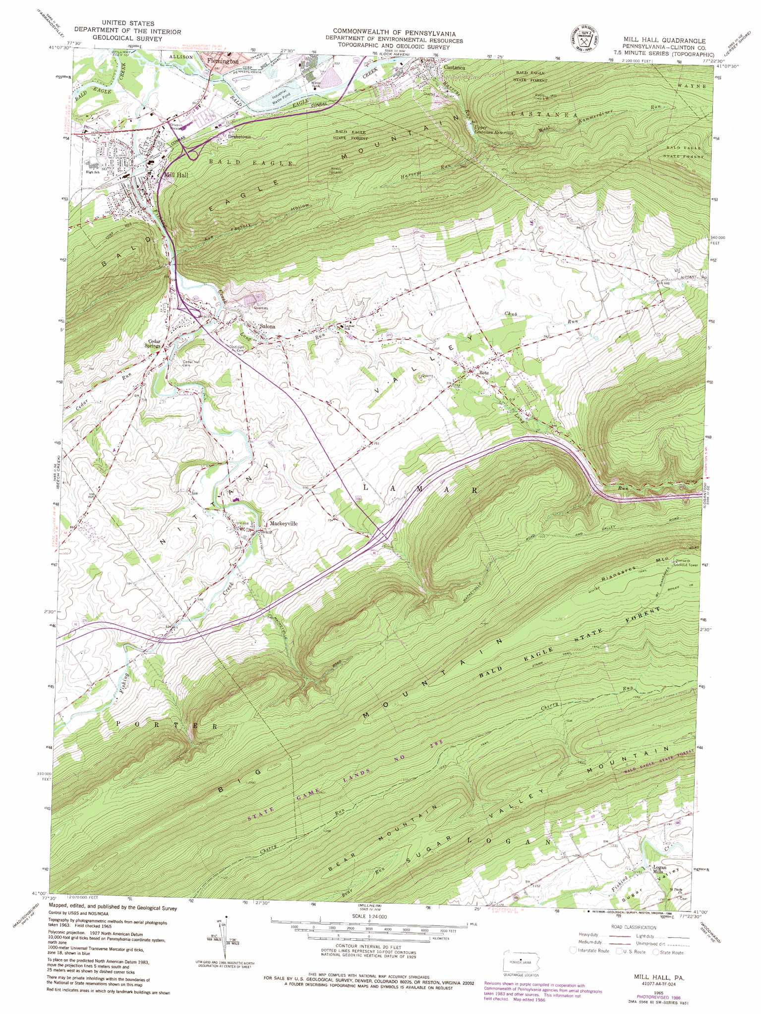
USGS Topo Quad 41077a4 - 1:24,000 scale
| Topo Map Name: | Mill Hall |
| USGS Topo Quad ID: | 41077a4 |
| Print Size: | ca. 21 1/4" wide x 27" high |
| Southeast Coordinates: | 41° N latitude / 77.375° W longitude |
| Map Center Coordinates: | 41.0625° N latitude / 77.4375° W longitude |
| U.S. State: | PA |
| Filename: | o41077a4.jpg |
| Download Map JPG Image: | Mill Hall topo map 1:24,000 scale |
| Map Type: | Topographic |
| Topo Series: | 7.5´ |
| Map Scale: | 1:24,000 |
| Source of Map Images: | United States Geological Survey (USGS) |
| Alternate Map Versions: |
Mill Hall PA 1965, updated 1966 Download PDF Buy paper map Mill Hall PA 1965, updated 1973 Download PDF Buy paper map Mill Hall PA 1965, updated 1986 Download PDF Buy paper map Mill Hall PA 2010 Download PDF Buy paper map Mill Hall PA 2013 Download PDF Buy paper map Mill Hall PA 2016 Download PDF Buy paper map |
1:24,000 Topo Quads surrounding Mill Hall
Renovo East |
Glen Union |
Jersey Mills |
Waterville |
Salladasburg |
Howard Nw |
Farrandsville |
Lock Haven |
Jersey Shore |
Linden |
Howard |
Beech Creek |
Mill Hall |
Loganton |
Carroll |
Mingoville |
Madisonburg |
Millheim |
Woodward |
Hartleton |
Centre Hall |
Spring Mills |
Coburn |
Weikert |
Beavertown |
> Back to 41077a1 at 1:100,000 scale
> Back to 41076a1 at 1:250,000 scale
> Back to U.S. Topo Maps home
Mill Hall topo map: Gazetteer
Mill Hall: Dams
Upper Castanea Reservoir Dam elevation 389m 1276′Mill Hall: Populated Places
Castanea elevation 182m 597′Cedar Springs elevation 184m 603′
Draketown elevation 189m 620′
Logan Mills elevation 353m 1158′
Mackeyville elevation 200m 656′
Mill Hall elevation 174m 570′
Rote elevation 229m 751′
Salona elevation 187m 613′
Mill Hall: Reservoirs
Upper Castanea Reservoir elevation 260m 853′Mill Hall: Ridges
The Talladega elevation 614m 2014′Mill Hall: Springs
Big Spring elevation 186m 610′Valley Dairy Spring elevation 200m 656′
Mill Hall: Streams
Axe Factory Run elevation 175m 574′Cedar Run elevation 182m 597′
Chub Run elevation 207m 679′
Fishing Creek elevation 165m 541′
Long Run elevation 183m 600′
West Kammerdiner Run elevation 263m 862′
Mill Hall: Summits
Big Mountain elevation 640m 2099′Riansares Mountain elevation 706m 2316′
Sugar Valley Mountain elevation 558m 1830′
Mill Hall: Trails
Stamm Trail elevation 603m 1978′Winter Trail elevation 693m 2273′
Mill Hall: Valleys
Axe Factory Hollow elevation 181m 593′Mill Hall digital topo map on disk
Buy this Mill Hall topo map showing relief, roads, GPS coordinates and other geographical features, as a high-resolution digital map file on DVD:
New York, Vermont, Connecticut & Western Massachusetts
Buy digital topo maps: New York, Vermont, Connecticut & Western Massachusetts