Elliott Park Topo Map Pennsylvania
To zoom in, hover over the map of Elliott Park
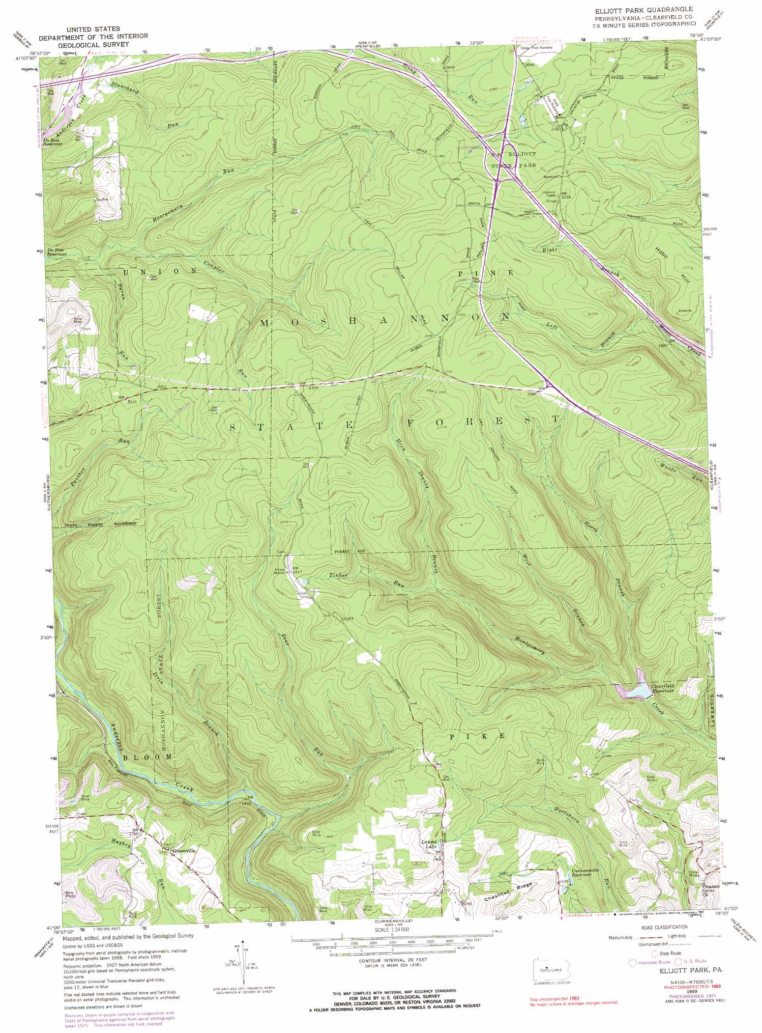
USGS Topo Quad 41078a5 - 1:24,000 scale
| Topo Map Name: | Elliott Park |
| USGS Topo Quad ID: | 41078a5 |
| Print Size: | ca. 21 1/4" wide x 27" high |
| Southeast Coordinates: | 41° N latitude / 78.5° W longitude |
| Map Center Coordinates: | 41.0625° N latitude / 78.5625° W longitude |
| U.S. State: | PA |
| Filename: | o41078a5.jpg |
| Download Map JPG Image: | Elliott Park topo map 1:24,000 scale |
| Map Type: | Topographic |
| Topo Series: | 7.5´ |
| Map Scale: | 1:24,000 |
| Source of Map Images: | United States Geological Survey (USGS) |
| Alternate Map Versions: |
Elliott Park PA 1959, updated 1960 Download PDF Buy paper map Elliott Park PA 1959, updated 1960 Download PDF Buy paper map Elliott Park PA 1959, updated 1972 Download PDF Buy paper map Elliott Park PA 1959, updated 1983 Download PDF Buy paper map Elliott Park PA 1959, updated 1991 Download PDF Buy paper map Elliott Park PA 2010 Download PDF Buy paper map Elliott Park PA 2013 Download PDF Buy paper map Elliott Park PA 2016 Download PDF Buy paper map |
1:24,000 Topo Quads surrounding Elliott Park
Carman |
Brandy Camp |
Kersey |
Weedville |
Dents Run |
Falls Creek |
Sabula |
Penfield |
Huntley |
The Knobs |
Du Bois |
Luthersburg |
Elliott Park |
Clearfield |
Lecontes Mills |
Mcgees Mills |
Mahaffey |
Curwensville |
Glen Richey |
Wallaceton |
Burnside |
Westover |
Irvona |
Ramey |
Houtzdale |
> Back to 41078a1 at 1:100,000 scale
> Back to 41078a1 at 1:250,000 scale
> Back to U.S. Topo Maps home
Elliott Park topo map: Gazetteer
Elliott Park: Areas
Bailey Field elevation 613m 2011′Elliott Park: Dams
Bear Run Dam elevation 495m 1624′Montgomery Dam elevation 415m 1361′
Elliott Park: Forests
Clearfield State Tree Nursery elevation 645m 2116′Elliott Park: Lakes
Laurel Lake elevation 573m 1879′Elliott Park: Parks
S B Elliott State Park elevation 646m 2119′Elliott Park: Populated Places
Glendale (historical) elevation 480m 1574′Greenville elevation 546m 1791′
Elliott Park: Reservoirs
Bear Run Reservoir elevation 495m 1624′Clearfield Reservoir elevation 424m 1391′
Curwensville Reservoir elevation 464m 1522′
Elliott Park: Ridges
Chestnut Ridge elevation 566m 1856′Elliott Park: Streams
Bear Run elevation 425m 1394′Blanchard Run elevation 518m 1699′
Burns Run elevation 521m 1709′
Coupler Run elevation 532m 1745′
Horn Shanty Branch elevation 552m 1811′
Irvin Branch elevation 435m 1427′
Left Branch Moose Creek elevation 582m 1909′
Montgomery Run elevation 520m 1706′
North Branch Montgomery Creek elevation 428m 1404′
Right Branch Moose Creek elevation 582m 1909′
Tinker Run elevation 552m 1811′
West Branch Montgomery Creek elevation 434m 1423′
Elliott Park: Summits
Bloom Run Vista elevation 551m 1807′Hobo Hill elevation 683m 2240′
Elliott Park digital topo map on disk
Buy this Elliott Park topo map showing relief, roads, GPS coordinates and other geographical features, as a high-resolution digital map file on DVD:
 map DVD")