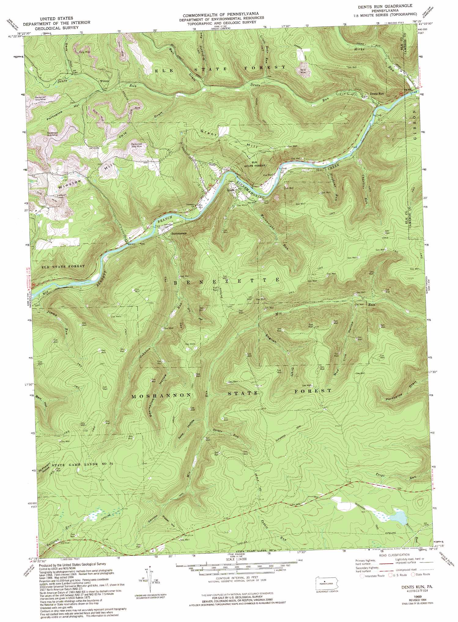
Dents Run Topo Map Pennsylvania
To zoom in, hover over the map of Dents Run
USGS Topo Quad 41078c3 - 1:24,000 scale
| Topo Map Name: | Dents Run |
| USGS Topo Quad ID: | 41078c3 |
| Print Size: | ca. 21 1/4" wide x 27" high |
| Southeast Coordinates: | 41.25° N latitude / 78.25° W longitude |
| Map Center Coordinates: | 41.3125° N latitude / 78.3125° W longitude |
| U.S. State: | PA |
| Filename: | o41078c3.jpg |
| Download Map JPG Image: | Dents Run topo map 1:24,000 scale |
| Map Type: | Topographic |
| Topo Series: | 7.5´ |
| Map Scale: | 1:24,000 |
| Source of Map Images: | United States Geological Survey (USGS) |
| Alternate Map Versions: |
Dents Run PA 1969, updated 1973 Download PDF Buy paper map Dents Run PA 1969, updated 1982 Download PDF Buy paper map Dents Run PA 1969, updated 1994 Download PDF Buy paper map Dents Run PA 2010 Download PDF Buy paper map Dents Run PA 2013 Download PDF Buy paper map Dents Run PA 2016 Download PDF Buy paper map |
1:24,000 Topo Quads surrounding Dents Run
Glen Hazel |
Wildwood Fire Tower |
Rich Valley |
Emporium |
Wharton |
Saint Marys |
Rathbun |
West Creek |
Cameron |
First Fork |
Kersey |
Weedville |
Dents Run |
Driftwood |
Sinnemahoning |
Penfield |
Huntley |
The Knobs |
Devils Elbow |
Pottersdale |
Elliott Park |
Clearfield |
Lecontes Mills |
Frenchville |
Karthaus |
> Back to 41078a1 at 1:100,000 scale
> Back to 41078a1 at 1:250,000 scale
> Back to U.S. Topo Maps home
Dents Run topo map: Gazetteer
Dents Run: Areas
Marion Brooks Natural Area elevation 638m 2093′Marion Brooks Natural Area elevation 658m 2158′
Quehanna Wild Area elevation 578m 1896′
Dents Run: Forests
Elk State Forest elevation 514m 1686′Dents Run: Populated Places
Dents Run elevation 281m 921′Grant elevation 298m 977′
Sumerson elevation 305m 1000′
Wilmer elevation 384m 1259′
Dents Run: Streams
Bells Branch Dents Run elevation 328m 1076′Charlies Run elevation 282m 925′
Deible Run elevation 483m 1584′
Dents Run elevation 273m 895′
Hicks Run elevation 268m 879′
Jimmy Run elevation 299m 980′
Johnson Run elevation 288m 944′
Little Bear Run elevation 302m 990′
McDonald Run elevation 324m 1062′
Stephens Run elevation 274m 898′
Wainwright Run elevation 280m 918′
Dents Run: Summits
Grant Hill elevation 505m 1656′Winslow Hill elevation 520m 1706′
Dents Run: Swamps
Beaver Run Shallow Water Impoundment elevation 586m 1922′Dents Run: Trails
Hodag Trail elevation 419m 1374′Quehanna Trail elevation 520m 1706′
Snooks Trail elevation 509m 1669′
Dents Run: Valleys
Bearwallow Hollow elevation 421m 1381′Bell Draft elevation 330m 1082′
Cole Draft elevation 334m 1095′
Dark Hollow elevation 394m 1292′
Dry Hollow elevation 365m 1197′
English Draft elevation 413m 1354′
Mud Lick Hollow elevation 370m 1213′
Porcupine Hollow elevation 382m 1253′
Ripper Hollow elevation 566m 1856′
Spike Hollow elevation 480m 1574′
Dents Run digital topo map on disk
Buy this Dents Run topo map showing relief, roads, GPS coordinates and other geographical features, as a high-resolution digital map file on DVD:
 map DVD")