Conneaut Lake Topo Map Pennsylvania
To zoom in, hover over the map of Conneaut Lake
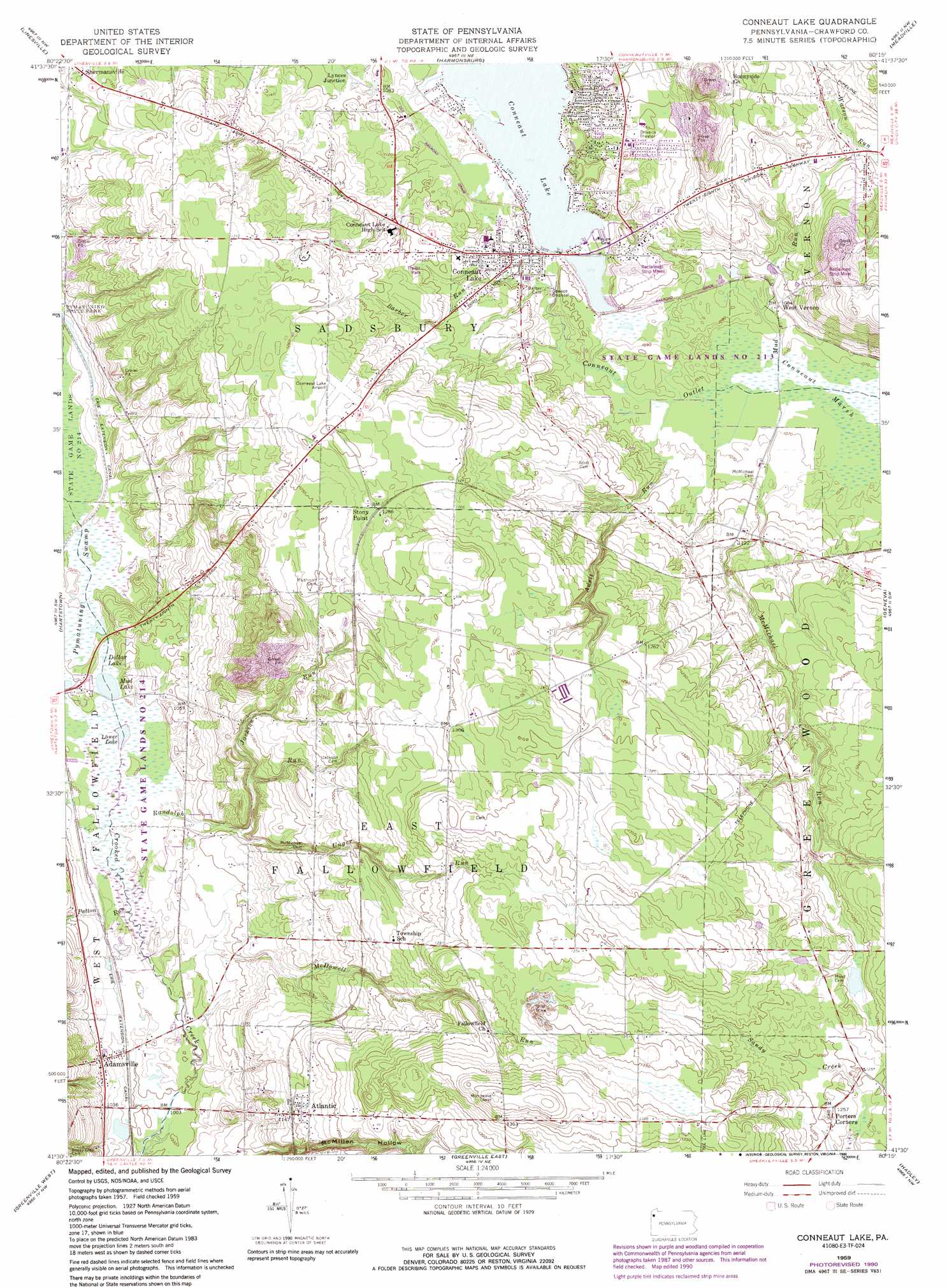
USGS Topo Quad 41080e3 - 1:24,000 scale
| Topo Map Name: | Conneaut Lake |
| USGS Topo Quad ID: | 41080e3 |
| Print Size: | ca. 21 1/4" wide x 27" high |
| Southeast Coordinates: | 41.5° N latitude / 80.25° W longitude |
| Map Center Coordinates: | 41.5625° N latitude / 80.3125° W longitude |
| U.S. State: | PA |
| Filename: | o41080e3.jpg |
| Download Map JPG Image: | Conneaut Lake topo map 1:24,000 scale |
| Map Type: | Topographic |
| Topo Series: | 7.5´ |
| Map Scale: | 1:24,000 |
| Source of Map Images: | United States Geological Survey (USGS) |
| Alternate Map Versions: |
Conneaut Lake PA 1959, updated 1960 Download PDF Buy paper map Conneaut Lake PA 1959, updated 1972 Download PDF Buy paper map Conneaut Lake PA 1959, updated 1972 Download PDF Buy paper map Conneaut Lake PA 1959, updated 1990 Download PDF Buy paper map Conneaut Lake PA 2010 Download PDF Buy paper map Conneaut Lake PA 2013 Download PDF Buy paper map Conneaut Lake PA 2016 Download PDF Buy paper map |
1:24,000 Topo Quads surrounding Conneaut Lake
Pierpont |
Beaver Center |
Conneautville |
Edinboro South |
Cambridge Springs |
Leon |
Linesville |
Harmonsburg |
Meadville |
Blooming Valley |
Andover |
Hartstown |
Conneaut Lake |
Geneva |
Cochranton |
Kinsman |
Greenville West |
Greenville East |
Hadley |
New Lebanon |
Orangeville |
Sharpsville |
Fredonia |
Jackson Center |
Sandy Lake |
> Back to 41080e1 at 1:100,000 scale
> Back to 41080a1 at 1:250,000 scale
> Back to U.S. Topo Maps home
Conneaut Lake topo map: Gazetteer
Conneaut Lake: Airports
Conneaut Lake Airport elevation 391m 1282′Conneaut Lake: Canals
Erie Extension Canal elevation 311m 1020′Conneaut Lake: Dams
Upper and Lower Dams elevation 308m 1010′Conneaut Lake: Lakes
Conneaut Lake elevation 327m 1072′Dollar Lake elevation 309m 1013′
Lower Lake elevation 310m 1017′
Mud Lake elevation 309m 1013′
Conneaut Lake: Parks
State Game Lands Number 214 elevation 309m 1013′Conneaut Lake: Populated Places
Adamsville elevation 319m 1046′Atlantic elevation 354m 1161′
Conneaut Lake elevation 330m 1082′
Lynces Junction elevation 329m 1079′
Porters Corners elevation 378m 1240′
Stony Point elevation 390m 1279′
West Vernon elevation 329m 1079′
Conneaut Lake: Post Offices
Conneaut Lake Post Office (historical) elevation 330m 1082′Conneaut Lake: Reservoirs
Pa-487 Reservoir elevation 308m 1010′Conneaut Lake: Streams
Adsit Run elevation 325m 1066′Barber Run elevation 334m 1095′
Jackson Run elevation 324m 1062′
McDowell Run elevation 308m 1010′
McMichael Run elevation 326m 1069′
Mud Run elevation 325m 1066′
Patton Run elevation 307m 1007′
Randolph Run elevation 307m 1007′
Unger Run elevation 317m 1040′
Conneaut Lake: Summits
Conneaut Lake Kame elevation 382m 1253′Conneaut Lake: Valleys
McMillen Hollow elevation 322m 1056′Conneaut Lake digital topo map on disk
Buy this Conneaut Lake topo map showing relief, roads, GPS coordinates and other geographical features, as a high-resolution digital map file on DVD:
 map DVD")