Cedarville Topo Map Indiana
To zoom in, hover over the map of Cedarville
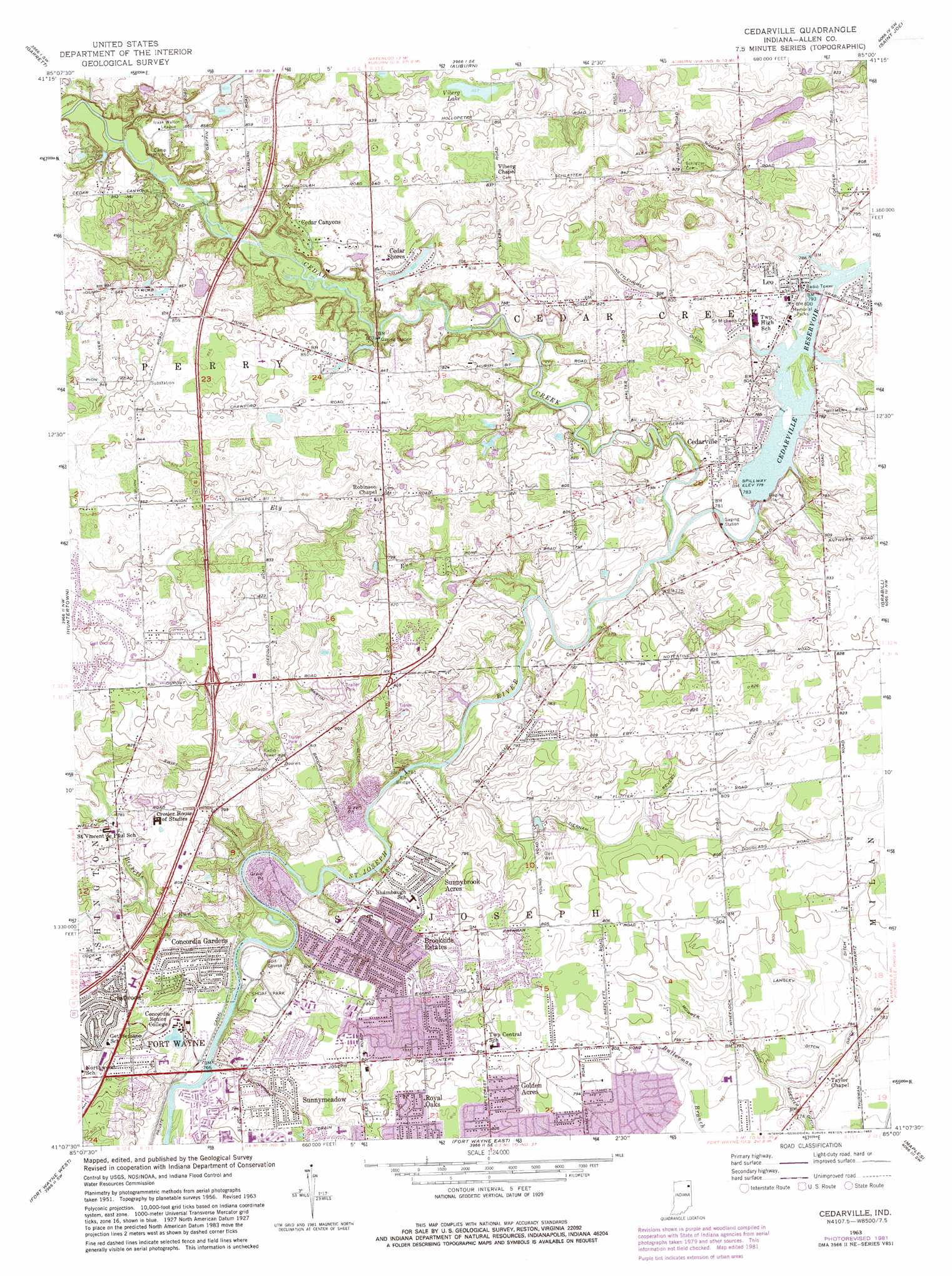
USGS Topo Quad 41085b1 - 1:24,000 scale
| Topo Map Name: | Cedarville |
| USGS Topo Quad ID: | 41085b1 |
| Print Size: | ca. 21 1/4" wide x 27" high |
| Southeast Coordinates: | 41.125° N latitude / 85° W longitude |
| Map Center Coordinates: | 41.1875° N latitude / 85.0625° W longitude |
| U.S. State: | IN |
| Filename: | o41085b1.jpg |
| Download Map JPG Image: | Cedarville topo map 1:24,000 scale |
| Map Type: | Topographic |
| Topo Series: | 7.5´ |
| Map Scale: | 1:24,000 |
| Source of Map Images: | United States Geological Survey (USGS) |
| Alternate Map Versions: |
Cedarville IN 1956, updated 1958 Download PDF Buy paper map Cedarville IN 1963, updated 1965 Download PDF Buy paper map Cedarville IN 1963, updated 1974 Download PDF Buy paper map Cedarville IN 1963, updated 1982 Download PDF Buy paper map Cedarville IN 2010 Download PDF Buy paper map Cedarville IN 2013 Download PDF Buy paper map Cedarville IN 2016 Download PDF Buy paper map |
1:24,000 Topo Quads surrounding Cedarville
Kendallville |
Corunna |
Waterloo |
Butler West |
Butler East |
Ege |
Garrett |
Auburn |
Saint Joe |
Hicksville |
Churubusco |
Huntertown |
Cedarville |
Grabill |
Woodburn North |
Arcola |
Fort Wayne West |
Fort Wayne East |
Maples |
Woodburn South |
Zanesville |
Ossian |
Poe |
Hoagland |
Dixon |
> Back to 41085a1 at 1:100,000 scale
> Back to 41084a1 at 1:250,000 scale
> Back to U.S. Topo Maps home
Cedarville topo map: Gazetteer
Cedarville: Airports
Exner Airport elevation 257m 843′Cedarville: Bridges
Ely Bridge elevation 232m 761′Cedarville: Canals
Alex Warner Ditch elevation 244m 800′Grice Ditch elevation 238m 780′
Langley Ditch elevation 238m 780′
Martin Ditch elevation 240m 787′
Mowrer Ditch elevation 237m 777′
Nettlehorst Ditch elevation 244m 800′
Revert Ditch elevation 243m 797′
Schoppman Drain elevation 237m 777′
Swift Ditch elevation 240m 787′
Tiernan Ditch elevation 231m 757′
Cedarville: Dams
Poe Lake Dam elevation 249m 816′Cedarville: Lakes
Viberg Lake elevation 254m 833′Cedarville: Parks
Camp McMillan elevation 260m 853′Shoaff Park elevation 237m 777′
Cedarville: Populated Places
Brookside Estates elevation 242m 793′Cedar Canyons elevation 258m 846′
Cedar Shores elevation 259m 849′
Cedarville elevation 240m 787′
Concordia Gardens elevation 239m 784′
Crestwood elevation 244m 800′
Golden Acres elevation 245m 803′
Leo elevation 241m 790′
Leo-Cedarville elevation 243m 797′
Royal Oaks elevation 245m 803′
Sunnybrook Acres elevation 243m 797′
Sunnymeadow elevation 237m 777′
Cedarville: Reservoirs
Cedarville Reservoir elevation 237m 777′Poe Lake elevation 249m 816′
Cedarville: Streams
Becketts Run elevation 230m 754′Cedar Creek elevation 232m 761′
Ely Run elevation 231m 757′
Cedarville digital topo map on disk
Buy this Cedarville topo map showing relief, roads, GPS coordinates and other geographical features, as a high-resolution digital map file on DVD:
Northern Illinois, Northern Indiana & Southwestern Michigan
Buy digital topo maps: Northern Illinois, Northern Indiana & Southwestern Michigan