Butler West Topo Map Indiana
To zoom in, hover over the map of Butler West
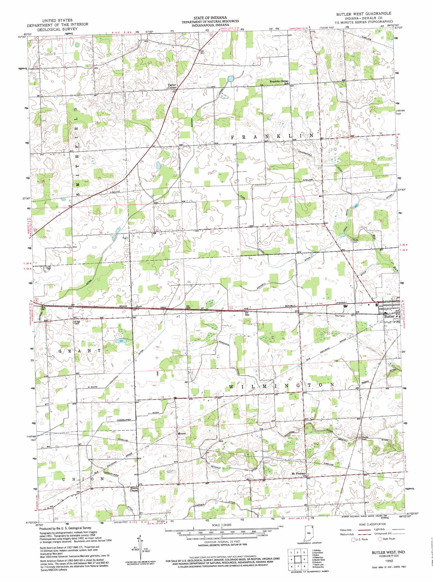
USGS Topo Quad 41084d8 - 1:24,000 scale
| Topo Map Name: | Butler West |
| USGS Topo Quad ID: | 41084d8 |
| Print Size: | ca. 21 1/4" wide x 27" high |
| Southeast Coordinates: | 41.375° N latitude / 84.875° W longitude |
| Map Center Coordinates: | 41.4375° N latitude / 84.9375° W longitude |
| U.S. State: | IN |
| Filename: | o41084d8.jpg |
| Download Map JPG Image: | Butler West topo map 1:24,000 scale |
| Map Type: | Topographic |
| Topo Series: | 7.5´ |
| Map Scale: | 1:24,000 |
| Source of Map Images: | United States Geological Survey (USGS) |
| Alternate Map Versions: |
Butler West IN 1958, updated 1959 Download PDF Buy paper map Butler West IN 1958, updated 1959 Download PDF Buy paper map Butler West IN 1992, updated 1995 Download PDF Buy paper map Butler West IN 2010 Download PDF Buy paper map Butler West IN 2013 Download PDF Buy paper map Butler West IN 2016 Download PDF Buy paper map |
1:24,000 Topo Quads surrounding Butler West
Orland |
Angola West |
Angola East |
Clear Lake |
Nettle Lake |
Stroh |
Ashley |
Hamilton |
Edon |
Blakeslee |
Corunna |
Waterloo |
Butler West |
Butler East |
Edgerton |
Garrett |
Auburn |
Saint Joe |
Hicksville |
Mark Center |
Huntertown |
Cedarville |
Grabill |
Woodburn North |
Antwerp |
> Back to 41084a1 at 1:100,000 scale
> Back to 41084a1 at 1:250,000 scale
> Back to U.S. Topo Maps home
Butler West topo map: Gazetteer
Butler West: Airports
Harrold Airport elevation 285m 935′Walker-Waterloo Airport elevation 274m 898′
Butler West: Canals
Donnell Ditch elevation 265m 869′Harwood Ditch elevation 263m 862′
Haverstock Ditch elevation 266m 872′
Hoodelmier Ditch elevation 265m 869′
King Ditch elevation 271m 889′
Mason Ditch elevation 261m 856′
Matson Ditch elevation 270m 885′
Metcalf Ditch elevation 255m 836′
Teutsch Ditch elevation 267m 875′
Varner Ditch elevation 259m 849′
W Smith Ditch elevation 268m 879′
Butler West: Populated Places
Moore elevation 268m 879′Taylor Corner elevation 281m 921′
Butler West digital topo map on disk
Buy this Butler West topo map showing relief, roads, GPS coordinates and other geographical features, as a high-resolution digital map file on DVD:
Northern Illinois, Northern Indiana & Southwestern Michigan
Buy digital topo maps: Northern Illinois, Northern Indiana & Southwestern Michigan