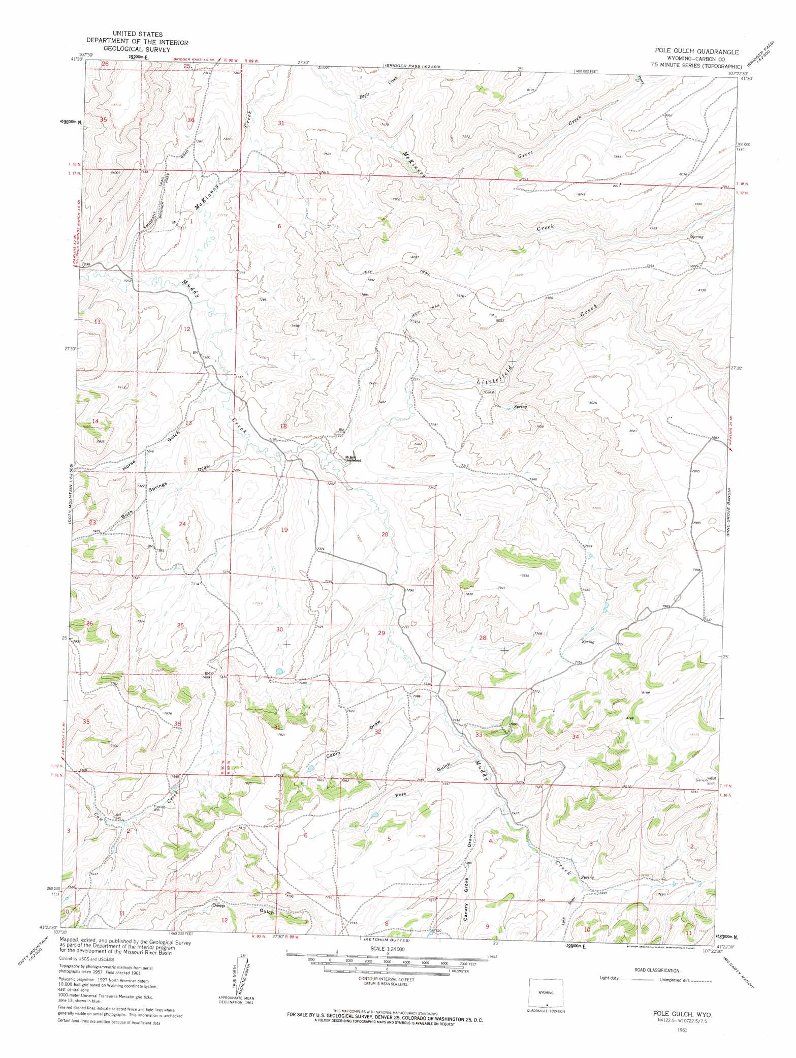
Pole Gulch Topo Map Wyoming
To zoom in, hover over the map of Pole Gulch
USGS Topo Quad 41107d4 - 1:24,000 scale
| Topo Map Name: | Pole Gulch |
| USGS Topo Quad ID: | 41107d4 |
| Print Size: | ca. 21 1/4" wide x 27" high |
| Southeast Coordinates: | 41.375° N latitude / 107.375° W longitude |
| Map Center Coordinates: | 41.4375° N latitude / 107.4375° W longitude |
| U.S. State: | WY |
| Filename: | o41107d4.jpg |
| Download Map JPG Image: | Pole Gulch topo map 1:24,000 scale |
| Map Type: | Topographic |
| Topo Series: | 7.5´ |
| Map Scale: | 1:24,000 |
| Source of Map Images: | United States Geological Survey (USGS) |
| Alternate Map Versions: |
Pole Gulch WY 1961, updated 1963 Download PDF Buy paper map Pole Gulch WY 1961, updated 1963 Download PDF Buy paper map Pole Gulch WY 2012 Download PDF Buy paper map Pole Gulch WY 2015 Download PDF Buy paper map |
1:24,000 Topo Quads surrounding Pole Gulch
Creston Junction |
Riner |
Separation Peak |
Coal Mine Ridge |
Smith Draw West |
Seaverson Reservoir |
Fillmore Ranch |
Bridge Pass |
La Marsh Creek West |
La Marsh Creek East |
Doty Mountain |
Sulphur Springs |
Pole Gulch |
Pine Grove Ranch |
Middlewood Hill |
Blue Gap |
Garden Gulch |
Ketchum Buttes |
Mccarty Ranch |
Divide Peak |
Peach Orchard Flat |
Smiley Draw |
Browns Hill |
Tullis |
Singer Peak |
> Back to 41107a1 at 1:100,000 scale
> Back to 41106a1 at 1:250,000 scale
> Back to U.S. Topo Maps home
Pole Gulch topo map: Gazetteer
Pole Gulch: Streams
Eagle Creek elevation 2218m 7276′Grove Creek elevation 2251m 7385′
Littlefield Creek elevation 2195m 7201′
McKinney Creek elevation 2159m 7083′
Stoney Creek elevation 2398m 7867′
Pole Gulch: Trails
Emigrant Trail elevation 2209m 7247′Pole Gulch: Valleys
Buck Springs Draw elevation 2189m 7181′Cabin Draw elevation 2234m 7329′
Canary Grove Draw elevation 2261m 7417′
Horse Gulch elevation 2182m 7158′
Lake Draw elevation 2284m 7493′
Pole Gulch elevation 2256m 7401′
Pole Gulch digital topo map on disk
Buy this Pole Gulch topo map showing relief, roads, GPS coordinates and other geographical features, as a high-resolution digital map file on DVD:
Eastern Wyoming & Western South Dakota
Buy digital topo maps: Eastern Wyoming & Western South Dakota