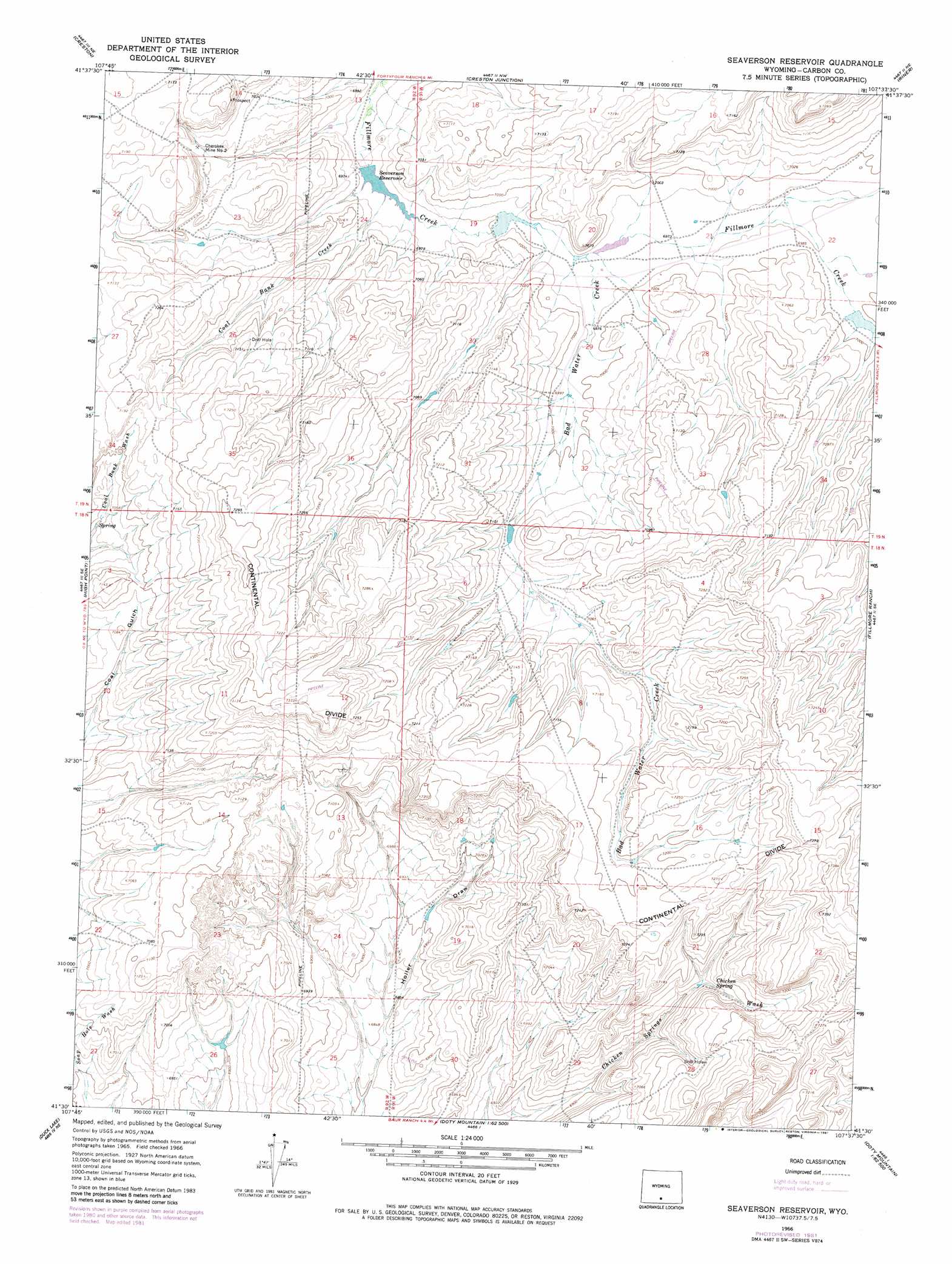
Seaverson Reservoir Topo Map Wyoming
To zoom in, hover over the map of Seaverson Reservoir
USGS Topo Quad 41107e6 - 1:24,000 scale
| Topo Map Name: | Seaverson Reservoir |
| USGS Topo Quad ID: | 41107e6 |
| Print Size: | ca. 21 1/4" wide x 27" high |
| Southeast Coordinates: | 41.5° N latitude / 107.625° W longitude |
| Map Center Coordinates: | 41.5625° N latitude / 107.6875° W longitude |
| U.S. State: | WY |
| Filename: | o41107e6.jpg |
| Download Map JPG Image: | Seaverson Reservoir topo map 1:24,000 scale |
| Map Type: | Topographic |
| Topo Series: | 7.5´ |
| Map Scale: | 1:24,000 |
| Source of Map Images: | United States Geological Survey (USGS) |
| Alternate Map Versions: |
Seaverson Reservoir WY 1966, updated 1969 Download PDF Buy paper map Seaverson Reservoir WY 1966, updated 1981 Download PDF Buy paper map Seaverson Reservoir WY 2012 Download PDF Buy paper map Seaverson Reservoir WY 2015 Download PDF Buy paper map |
1:24,000 Topo Quads surrounding Seaverson Reservoir
Monument Lake |
Ruby Knolls |
Jawbone Ranch |
Antelope Spring |
Rawlins Peak Sw |
Wamsutter |
Creston |
Creston Junction |
Riner |
Separation Peak |
Eightmile Lake |
High Point |
Seaverson Reservoir |
Fillmore Ranch |
Bridge Pass |
Mexican Flats Nw |
Duck Lake |
Doty Mountain |
Sulphur Springs |
Pole Gulch |
South Barrel Spring |
Mexican Flats |
Blue Gap |
Garden Gulch |
Ketchum Buttes |
> Back to 41107e1 at 1:100,000 scale
> Back to 41106a1 at 1:250,000 scale
> Back to U.S. Topo Maps home
Seaverson Reservoir topo map: Gazetteer
Seaverson Reservoir: Dams
Seaverson Dam elevation 2121m 6958′Seaverson Reservoir: Mines
Cherokee Mine Number 2 elevation 2146m 7040′Seaverson Reservoir: Reservoirs
Seaverson Reservoir elevation 2121m 6958′Seaverson Reservoir: Springs
Chicken Spring elevation 2149m 7050′Seaverson Reservoir: Streams
Bad Water Creek elevation 2128m 6981′Coal Bank Creek elevation 2121m 6958′
Seaverson Reservoir digital topo map on disk
Buy this Seaverson Reservoir topo map showing relief, roads, GPS coordinates and other geographical features, as a high-resolution digital map file on DVD:
Eastern Wyoming & Western South Dakota
Buy digital topo maps: Eastern Wyoming & Western South Dakota