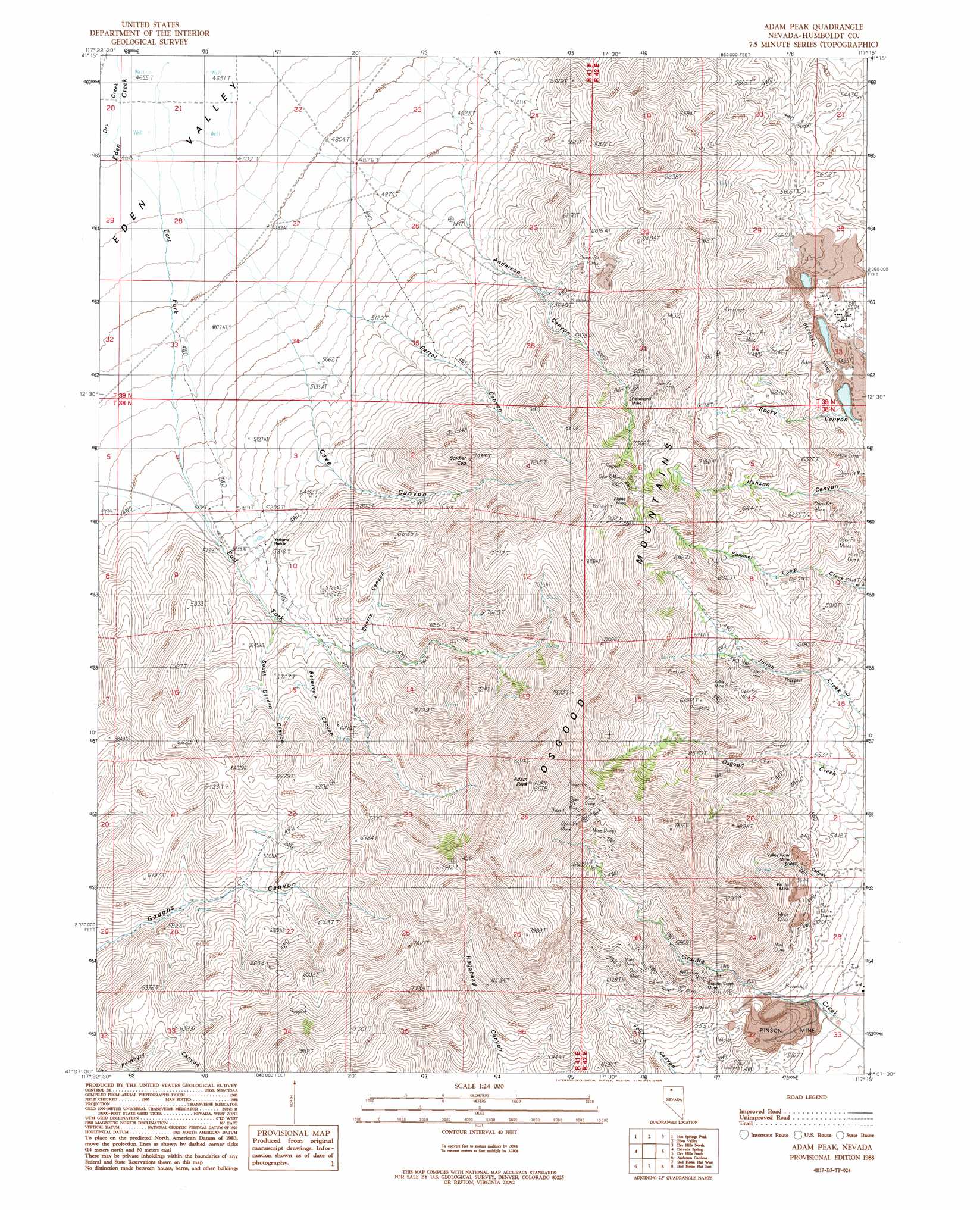
Adam Peak Topo Map Nevada
To zoom in, hover over the map of Adam Peak
USGS Topo Quad 41117b3 - 1:24,000 scale
| Topo Map Name: | Adam Peak |
| USGS Topo Quad ID: | 41117b3 |
| Print Size: | ca. 21 1/4" wide x 27" high |
| Southeast Coordinates: | 41.125° N latitude / 117.25° W longitude |
| Map Center Coordinates: | 41.1875° N latitude / 117.3125° W longitude |
| U.S. State: | NV |
| Filename: | o41117b3.jpg |
| Download Map JPG Image: | Adam Peak topo map 1:24,000 scale |
| Map Type: | Topographic |
| Topo Series: | 7.5´ |
| Map Scale: | 1:24,000 |
| Source of Map Images: | United States Geological Survey (USGS) |
| Alternate Map Versions: |
Adam Peak NV 1988, updated 1989 Download PDF Buy paper map Adam Peak NV 2011 Download PDF Buy paper map Adam Peak NV 2015 Download PDF Buy paper map |
1:24,000 Topo Quads surrounding Adam Peak
Paradise Valley |
Little Poverty |
Fairbanks Canyon |
Chimney Reservoir |
Layton Spring |
Willow Point |
Hot Springs Peak |
Eden Valley |
Dry Hills North |
Kenny Creek |
Gumboot Lake |
Delvada Spring |
Adam Peak |
Dry Hills South |
The Knolls |
Golconda Butte |
Anderson Gardens |
Red House Flat West |
Red House Flat East |
Elevenmile Well |
Pole Creek |
Golconda |
Iron Point |
Knight |
Hot Pot |
> Back to 41117a1 at 1:100,000 scale
> Back to 41116a1 at 1:250,000 scale
> Back to U.S. Topo Maps home
Adam Peak topo map: Gazetteer
Adam Peak: Airports
Pinson Mining Company Landing Strip elevation 1515m 4970′Adam Peak: Mines
Alpine Mine elevation 2293m 7522′Getchell Mine elevation 1703m 5587′
Getchell Section Five Pit elevation 2002m 6568′
Granite Creek Mine elevation 1721m 5646′
Kirby Mine elevation 1924m 6312′
Marcus Mine elevation 2339m 7673′
Mountain King Mine elevation 2181m 7155′
Pacific Mine elevation 1694m 5557′
Pinson Mine elevation 1624m 5328′
Reilly Mine elevation 1659m 5442′
Richmond Mine elevation 2014m 6607′
T N T Mine elevation 1956m 6417′
Tip Top Mine elevation 1921m 6302′
Tonopah Mine elevation 1739m 5705′
Top Row Mine elevation 1700m 5577′
Valley View Mine elevation 1647m 5403′
Adam Peak: Populated Places
Getchell elevation 1710m 5610′Adam Peak: Ranges
Dry Hills elevation 2014m 6607′Adam Peak: Springs
Soldiers Cap Spring elevation 1953m 6407′Adam Peak: Streams
Dry Creek elevation 1425m 4675′East Fork Eden Creek elevation 1418m 4652′
Soldier Cap Creek elevation 1432m 4698′
Adam Peak: Summits
Adam Peak elevation 2634m 8641′Soldier Cap elevation 2123m 6965′
Adam Peak: Valleys
Anderson Canyon elevation 1465m 4806′Bunch Canyon elevation 1547m 5075′
Cave Canyon elevation 1511m 4957′
Cherry Canyon elevation 1750m 5741′
Farrel Canyon elevation 1478m 4849′
Reservoir Canyon elevation 1688m 5538′
South Garden Canyon elevation 1653m 5423′
Adam Peak digital topo map on disk
Buy this Adam Peak topo map showing relief, roads, GPS coordinates and other geographical features, as a high-resolution digital map file on DVD: